Johnson, Ontario
Johnson is a township in the Canadian province of Ontario, located within the Algoma District. The township had a population of 751 in the Canada 2016 Census, up from 750 in the 2011 census.
Johnson | |
|---|---|
| Township of Johnson | |
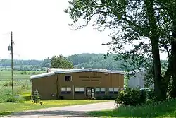 Municipal building in Desbarats | |
 Johnson | |
| Coordinates: 46°20′N 83°56′W | |
| Country | Canada |
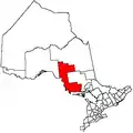
| Province | Ontario |
| District | Algoma |
| Government | |
| • Type | Township |
| • Mayor | Blaine Mersereau |
| • MP | Carol Hughes (NDP) |
| • MPP | Michael Mantha (NDP) |
| Area | |
| • Land | 120.27 km2 (46.44 sq mi) |
| Population (2016)[1] | |
| • Total | 751 |
| • Density | 6.2/km2 (16/sq mi) |
| Time zone | UTC-5 (EST) |
| • Summer (DST) | UTC-4 (EDT) |
| Postal code | P0R 1E0 |
| Area code(s) | 705 and 249 |
| Website | www.johnsontownship.ca |
Communities
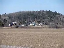
Desbarats, the main community in the township, is located on Highway 17, 54 kilometres (34 mi) east of Sault Ste. Marie.
Located in Desbarats is Central Algoma Secondary School, a high school of 250+ students which serves a catchment area extending from Echo Bay to Thessalon. In 2013 a grade 7 and 8 program was put into place in CASS.
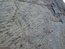
West of Desbarats on Highway 17 is Ripple Rock, a unique rock cut that was uncovered with the blasting of the rock cuts through northern Ontario for the creation of the Trans-Canada Highway. The ripples in the rock were created two billion years ago by waves in a shallow body of water. It was buried and through pressure it became sandstone.
Puddingstone Road in Johnson Township was named for a type of puddingstone locally known as Jasper conglomerate and often found in the area as well as at nearby St. Joseph Island. Puddingstone is a mixture of different sized grains and pebbles held together by finer sand. The type found in this area is St. Joseph Island Puddingstone, which contains red and brown pieces of jasper.
Since the early 2000s, about 20 Mennonite families from Southern Ontario moved to the Desbarats area. Along with other local farmers, they sell their produce at the Desbarats Farmers' Market on Friday evenings and Saturday mornings.
Demographics
| Canada census – Johnson, Ontario community profile | |||
|---|---|---|---|
| 2016 | 2011 | 2006 | |
| Population: | 751 (0.1% from 2011) | 750 (7.0% from 2006) | 701 (6.5% from 2001) |
| Land area: | 120.27 km2 (46.44 sq mi) | 120.38 km2 (46.48 sq mi) | 119.67 km2 (46.20 sq mi) |
| Population density: | 6.2/km2 (16/sq mi) | 6.2/km2 (16/sq mi) | 5.9/km2 (15/sq mi) |
| Median age: | 44.6 (M: 46.0, F: 43.6) | 44.5 (M: 45.2, F: 43.5) | |
| Total private dwellings: | 521 | 408 | 449 |
| Median household income: | $48,771 | ||
| References: 2016[2] 2011[3] 2006[4] earlier[5] | |||
Population trend:[6]
- Population in 2016: 751
- Population in 2011: 750
- Population in 2006: 701
- Population in 2001: 658
- Population in 1996: 729
- Population in 1991: 685
Transportation
Ontario Northland provides intercity motor coach service to the main community of Desbarats as a stop along its Sault Ste. Marie–Sudbury–North Bay–Ottawa route, with one bus a day each headed eastbound and westbound from Sunday to Friday, with no service on Saturdays.
See also
References
- "Johnson census profile". 2016 Census of Population. Statistics Canada. Retrieved 2019-06-04.
- "2016 Community Profiles". 2016 Canadian Census. Statistics Canada. February 21, 2017. Retrieved 2016-06-04.
- "2011 Community Profiles". 2011 Canadian Census. Statistics Canada. July 5, 2013. Retrieved 2012-02-17.
- "2006 Community Profiles". 2006 Canadian Census. Statistics Canada. March 30, 2011. Retrieved 2012-02-17.
- "2001 Community Profiles". 2001 Canadian Census. Statistics Canada. February 17, 2012.
- Statistics Canada:2011 1996, 2001, 2006 census
External links
| Wikimedia Commons has media related to Johnson, Ontario. |
Places adjacent to Johnson, Ontario | ||||||||||
|---|---|---|---|---|---|---|---|---|---|---|
| ||||||||||