White River, Ontario
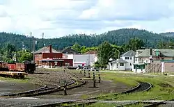
White River is a township located in Ontario, Canada, on the intersection of Highway 17 and Highway 631. It was originally set up as a rail town on the Canadian Pacific Railway in 1885. In 1961, it was finally made accessible by car via Highway 17 of the Trans-Canada Highway.
White River | |
|---|---|
| Township of White River | |
 | |
 White River | |
| Coordinates: 48°35′N 85°17′W | |
| Country | Canada |
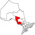
| Province | Ontario |
| District | Algoma |
| Established | 1885 |
| Government | |
| • Type | Township |
| • Mayor | Angelo Bazzoni |
| • Federal riding | Algoma—Manitoulin—Kapuskasing |
| • Prov. riding | Algoma—Manitoulin |
| Area | |
| • Land | 96.78 km2 (37.37 sq mi) |
| Population (2016)[1] | |
| • Total | 645 |
| • Density | 6.7/km2 (17/sq mi) |
| Time zone | UTC-5 (EST) |
| • Summer (DST) | UTC-4 (EDT) |
| Postal Code | P0M |
| Area code(s) | 807 |
| Highways | |
| Website | www |
The forest industry was the largest employer until 2007, when the Domtar mill shut down. In 2013, the Domtar assets were purchased by the Township of White River and the Pic Mobert First Nation along with private partners. The mill was then reopened, with significant investment in new equipment, as White River Forest Products LP.[2]
The township is perhaps best known for being the home of Winnie the Pooh. In August 1914, a trapped black bear cub was sold to Captain Harry Colebourn in White River, and Colebourn named it Winnipeg, or Winnie, after his hometown of Winnipeg, Manitoba. Over the years, the animal became the basis for the popular literary character. The town celebrates "Winnie's Hometown Festival" every third week in August.
Climate

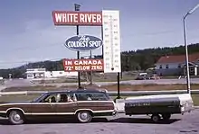
White River advertises itself as "The Coldest Spot in Canada" with recorded temperatures as low as −58 °C (−72 °F). However, this is a myth, as the coldest temperature in Canada was recorded in Snag, Yukon, at −62.8 °C (−81.0 °F) on 3 February 1947.[3] Even in Ontario, the coldest recorded temperature was in Iroquois Falls on 23 January 1935 [−58.3 °C (−72.9 °F)], which is also the lowest temperature ever recorded in Eastern Canada.[3] White River's reputation for being the "coldest spot" is probably based on the fact that for many years, its reported temperature was deemed "the coldest in the nation today" from the handful of stations reporting daily temperature extremes in newspapers and on radio, with most stations' data being available only on a monthly basis to Environment Canada at the time.
Its official weather station (which closed in 1976) was located in a frost hollow, but most residential areas have good air drainage and do not see temperatures far below −40 °C (−40 °F). Gardeners can keep their flowers alive into October and grow non-boreal species such as silver maple.
Popular culture
White River is referenced by the Canadian singer/songwriter Christine Fellows in her song "Migrations". It's also the title of a great Canadian breakup song by Tyler Ellis, entitled "White River" no less.
Transportation

White River station is the western terminus of Via Rail's thrice-weekly Sudbury – White River train, which operates east to Greater Sudbury. Greyhound Canada stopped serving White River on 31 October 2018, when it ended all service west of Sudbury. Ontario Northland buses continue to serve White River.[4]
Demographics
| Canada census – White River, Ontario community profile | |||
|---|---|---|---|
| 2016 | 2011 | 2006 | |
| Population: | 645 (+6.3% from 2011) | 607 (-27.8% from 2006) | 841 (-15.3% from 2001) |
| Land area: | 96.78 km2 (37.37 sq mi) | 96.94 km2 (37.43 sq mi) | 96.94 km2 (37.43 sq mi) |
| Population density: | 6.3/km2 (16/sq mi) | 6.3/km2 (16/sq mi) | 8.7/km2 (23/sq mi) |
| Median age: | 48.0 (M: 48.8, F: 47.3) | 42.2 (M: 42.6, F: 41.9) | |
| Total private dwellings: | 411 | 435 | 443 |
| Median household income: | $74,752 | $57,297 | |
| References: 2016[5] 2011[6] 2006[7] earlier[8] | |||
- Population in 2016: 645 (+6.3% from 2011)
- Population in 2011: 607
- Population in 2006: 841
- Population in 2001: 993
- Population in 1996: 1,022
- Population in 1991: 948
Mother tongue:[11]
- English as first language: 78%
- French as first language: 16%
- English and French as first language: 1%
- Other as first language: 5%
In 2006, the township was 61% White, 26% Metis, and 13% First Nations.
References
- "Census Profile, 2016 Census: White River, Township". Statistics Canada. Retrieved 9 June 2019.
- "White River Forest Products Ltd. Fact Sheet" (PDF). Pic Mobert First Nation. Retrieved 13 November 2018.
- David Phillips. "Cold Places in Canada". Histor!ca The Canadian Encyclopedia. Retrieved 20 June 2008.
- Walters, Jeff (26 September 2018). "Going without Greyhound: Travellers to end up stranded with loss of connections". CBC. Retrieved 1 February 2019.
- "2016 Community Profiles". 2016 Canadian Census. Statistics Canada. 21 February 2017. Retrieved 9 June 2019.
- "2011 Community Profiles". 2011 Canadian Census. Statistics Canada. 5 July 2013. Retrieved 17 February 2012.
- "2006 Community Profiles". 2006 Canadian Census. Statistics Canada. 30 March 2011. Retrieved 17 February 2012.
- "2001 Community Profiles". 2001 Canadian Census. Statistics Canada. 17 February 2012.
- Statistics Canada: 1996, 2001, 2006 census
- "White River census profile". 2011 Census of Population. Statistics Canada. Retrieved 17 February 2012.
- "White River, Ontario - 2006", Community Profiles, Statistics Canada, retrieved 31 January 2016
External links
| Wikimedia Commons has media related to White River, Ontario. |
Places adjacent to White River, Ontario | |
|---|---|