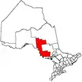
The North Shore, Ontario
The North Shore is a township in the Canadian province of Ontario, located in the Algoma District. The township had a population of 497 in the Canada 2016 Census. It is along the north shore of the North Channel of Lake Huron (hence its name), with its main communities all along Highway 17.
The North Shore | |
|---|---|
| Township of The North Shore | |
 North Shore municipal offices. | |
 The North Shore | |
| Coordinates: 46°14′N 82°38′W | |
| Country | Canada |
| Province | Ontario |
| District | Algoma |
| Incorporated | 1978 |
| Government | |
| • Type | Township |
| • Mayor | Tony Moor |
| • Governing Body | North Shore Township Council |
| • MP | Carol Hughes (NDP) |
| • MPP | Michael Mantha (NDP) |
| Area | |
| • Land | 239.08 km2 (92.31 sq mi) |
| Population (2016)[1] | |
| • Total | 497 |
| • Density | 2.1/km2 (5/sq mi) |
| Time zone | UTC−5 (EST) |
| • Summer (DST) | UTC−4 (EDT) |
| Postal code FSA | P0R |
| Area code(s) | 705 |
| Website | www.townshipofthe northshore.ca |
Communities
Algoma Mills
Algoma Mills is located between the North Channel and Lauzon Lake, near the township's western boundary with Blind River. The Algoma Mills Water Aerodrome serves the community.
Moiles Mills
Moiles Mills is a ghost town. It was established as a lumber town in April 1889 and burned down in 1918. The former townsite is now the site of John Island Camp, a children's summer camp operated by the YMCA.
Spragge
Originally known as Cook's Mills, in 1882 the Cook Brothers Lumber Company established a sawmill at this location on the north shore of Lake Huron. The mill operated until 1906 when it was sold to Waldie Brothers Lumber Company. With the mill no longer in Cook's ownership, Spragge (the original name of the township in which it is located), was adopted as the name of the community. Waldie Brothers in turn sold the mill to McFadden and Malloy in 1913.
Over time a small village with a school, hotel, barbershop, general store was created, and by 1926 the community had a population of about 300 people. Sawmill activity was terminated in Spragge in the early 1930s following a disastrous fire, which eliminated the mill, lumber inventory, docks and most of the town. The town subsequently revived with the discovery of uranium and copper deposits in the area, leading to a thriving mining industry.
Demographics
| Canada census – The North Shore, Ontario community profile | |||
|---|---|---|---|
| 2016 | 2011 | 2006 | |
| Population: | 497 (-2.4% from 2011) | 509 (-7.3% from 2006) | 549 (0.9% from 2001) |
| Land area: | 239.08 km2 (92.31 sq mi) | 238.94 km2 (92.26 sq mi) | 230.79 km2 (89.11 sq mi) |
| Population density: | 2.1/km2 (5.4/sq mi) | 2.1/km2 (5.4/sq mi) | 2.4/km2 (6.2/sq mi) |
| Median age: | 59.9 (M: 60.8, F: 58.7) | 56.2 (M: 56.8, F: 55.9) | 53.5 (M: 55.2, F: 52.3) |
| Total private dwellings: | 367 | 370 | 342 |
| Median household income: | $45,809 | ||
| References: 2016[1] 2011[2] 2006[3] earlier[4] | |||
Population trend:[5]
- Population in 2016: 497
- Population in 2011: 509
- Population in 2006: 549
- Population in 2001: 544
- Population in 1996: 678
- Population in 1991: 729
Images
 Algoma Mills and Lauzon Lake
 Turn of the century view of the main street in Moiles Mills
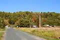 Serpent River
 Spragge
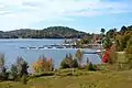 Marina in Spragge
References
- "2016 Community Profiles". 2016 Canadian Census. Statistics Canada. February 21, 2017. Retrieved 2016-06-04.
- "2011 Community Profiles". 2011 Canadian Census. Statistics Canada. July 5, 2013. Retrieved 2012-02-17.
- "2006 Community Profiles". 2006 Canadian Census. Statistics Canada. March 30, 2011. Retrieved 2011-03-07.
- "2001 Community Profiles". 2001 Canadian Census. Statistics Canada. February 17, 2012.
- Statistics Canada: 1996, 2001, 2006, 2011 census
External links
| Wikimedia Commons has media related to The North Shore, Ontario. |
Places adjacent to The North Shore, Ontario | |
|---|---|