Whitefish Island
Whitefish Island is an island in the St. Marys River, just south of Sault Ste. Marie, in Ontario, Canada.
Whitefish Island | |
|---|---|
| Whitefish Island Indian Reserve | |
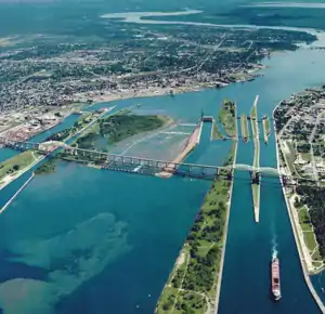 Aerial view of the St. Marys River; Whitefish Island is just to the left of the rapids. | |
 Whitefish Island | |
| Coordinates: 46°31′N 84°21′W | |
| Country | |
| Province | |
| District | Algoma |
| First Nation | Batchewana Ojibways |
| Area | |
| • Land | 0.17 km2 (0.07 sq mi) |
| Population (2011) | |
| • Total | 0 |
| • Density | 0/km2 (0/sq mi) |
| Time zone | UTC-5 (EST) |
| • Summer (DST) | UTC-4 (EDT) |
| Website | www.batchewana.ca |
| Official name | Whitefish Island National Historic Site of Canada |
| Designated | 1981 |
History
It was an ancestral fishing station to the Anishenabek of the Great Lakes region for over 2,000 years. It was reserved for the use of Chief 'Joe Sayer' Nebenaigoching and his band in the Robinson Huron Treaty, 1850 with the British Crown.
In 1895 it became part of the west side of the Sault Ste. Marie Canal.
After it was taken in a series of expropriations from 1902 to 1913 for railway purposes, it became a park in the Parks Canada national inventory. The island was designated a National Historic Site of Canada in 1981.[1]
A land claim was filed in 1982 by the Batchewana Indian Band, of the Batchewana First Nation of Ojibways, for the 22-acre (89,000 m2) island. After years of unsuccessful negotiations, hereditary Chief Edward James Sayers Nebenaigoching occupied the island from 1989 until the claim was settled in 1992. 3.5 million dollars in damages were paid to the tribe, and the island was returned to Indian reserve status in 1997.
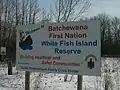 Welcome to White Fish Island
 Ancient fishing weir
_2.JPG.webp) Birch bark longhouse
Birch bark longhouse Longhouse in winter
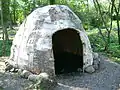 Birch bark lodge
 Boardwalk with 7 flood control gates open (equivalent).
 Sault Ste. Marie waterfront, as seen from Whitefish Island
 St. Marys Rapids
 Beaver dams along Whitefish Channel
_13.JPG.webp) February daphne flowers (native to Eurasia, unknown how they arrived)
February daphne flowers (native to Eurasia, unknown how they arrived).JPG.webp) Narrow-leaf blue-eyed grass flowers near the St. Marys Rapids
Narrow-leaf blue-eyed grass flowers near the St. Marys Rapids_1.JPG.webp)
_3.JPG.webp)
 Trout-lily flower in early spring
Trout-lily flower in early spring_1.JPG.webp) Wild leek in early spring
Wild leek in early spring_1.JPG.webp) Wild raisin in fruit
Wild raisin in fruit_2.JPG.webp) Steelhead trout caught in the St. Marys Rapids (introduced species)
Steelhead trout caught in the St. Marys Rapids (introduced species)
References
- Whitefish Island. Canadian Register of Historic Places. Retrieved July 29, 2011.
External links
| Wikimedia Commons has media related to Whitefish Island. |
Places adjacent to Whitefish Island | |
|---|---|
| Provinces | |
|---|---|
| Territories | |
| Other countries | |
| |