Wawa, Ontario
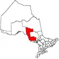
Wawa is a township in the Canadian province of Ontario, located within the Algoma District and associated with Wawa Lake. Formerly known as the township of Michipicoten, after a nearby river of that name, the township was officially renamed in 2007 for its largest and best-known community of Wawa.[3]
Wawa | |
|---|---|
| Municipality of Wawa Township of Michipicoten (pre-2007) | |
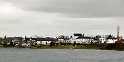 Wawa as seen across Wawa Lake | |
 Wawa | |
| Coordinates: 47°59′35″N 84°46′25″W | |
| Country | Canada |
| Province | Ontario |
| District | Algoma |
| Established | 1899 |
| Government | |
| • Mayor | Ron Rody |
| • Federal riding | Algoma—Manitoulin—Kapuskasing |
| • Prov. riding | Algoma—Manitoulin |
| Area | |
| • Land | 416.21 km2 (160.70 sq mi) |
| Elevation | 287 m (942 ft) |
| Population (2016)[1] | |
| • Total | 2,905 |
| • Density | 7.0/km2 (18/sq mi) |
| Time zone | UTC-5 (Eastern Standard Time (EST)) |
| • Summer (DST) | UTC-4 (Eastern Daylight Time (EDT)) |
| Postal Code | P0S 1K0 |
| Area code(s) | 705 |
| Website | www.wawa.cc |
This area was first developed for fur trading. In the late 19th century, both gold and iron ore were found and mined, leading to the region's rise as the steel industry developed in Sault Ste. Marie, Ontario. From 1900-1918 the Helen Mine had the highest production of iron ore of any mine in Canada.
The township includes the smaller communities of Michipicoten and Michipicoten River, which are small port settlements on the shore of Lake Superior. These names are derived from the Ojibwe term for the river.
History
Fur trade days
Fort Michipicoten was constructed at the mouth of the Michipicoten River. It was at the junction of the main fur trade route from Montreal westward and the route to James Bay via the Missinaibi River. The town developed five miles upriver from here.
.jpg.webp)
French explorers reached the area by at least 1681, and militia built the post in either 1725 or 1727.[4] By 1729, it was an outpost of Fort Kaministiquia in Vérendrye's Postes du Nord. The site was on the south bank of the river, opposite the mouth of the Magpie River. When the British conquered Canada in 1763, this post was abandoned.
Four years later, it was re-opened on the same site by fur traders Alexander Henry the elder and Jean Baptiste Cadotte. The route from James Bay was explored by Edward Jarvis (1775) and Philip Turnor (1781). In 1783, it was taken over by the North West Company, based in Montreal. In 1797, the Hudson's Bay Company built a rival post on the north bank.
With the union of the two companies in 1821, the Lake Superior trade was diverted from Montreal to Hudson Bay via Michipicoten. This lasted until 1863, when the arrival of steamboats and railways made it unnecessary. From 1827, the fort was the headquarters of the Superior Division, and several annual meetings were held here. It was a centre for fishing, boat-building and small-scale manufacture and repair. It also served as a base for missionaries and surveyors. It was closed in 1904 and gradually taken apart. By 1980 the site held little more than a grassy clearing, some foundation stones, and the remains of the dock.[5][6]
Modern
Wawa's history is rich in mining, forestry, and the fur trade. Mining attempts began as early as the late 1660s.
William Teddy discovered gold on Wawa Lake in 1897. The population of Wawa village quickly grew with 1,700 claims staked in 1898. However, most gold production stopped by 1906. Beginning in 1914 with the completion of the Algoma Central Railway, gold production commenced again from 22 prospects.[7]
In 1898, the town site at what is now called "the Mission" was registered as "Michipicoten City." In 1899, Wawa was surveyed and plotted as a town and registered as Wawa City. In the latter half of the 1950s, the town's name was temporarily changed to Jamestown in honour of Sir James Hamet Dunn, but it was later returned to Wawa at the request of the community's residents.
Gold production had slowed by 1906, but as mining technology improved, additional amounts began to be extracted from the area. Gold mining in the Wawa area prospered and receded several times in the 20th century, and it continues today. Notable producers include the Grace Mine (1902-1944), which produced 15,191 ounces, the Minto Mine (1929-1942), which produced 37,678 ounces, the Parkhill Mine (1902-1944), which produced 54,301 ounces, and the Renabie Mine (1920-1991), which produced 1.1 million ounces.[7]
Iron ore extraction has also been an important industry in the area. The search for gold during the Michipicoten boom led to the unexpected discovery in 1897 of iron ore. Francis Hector Clergue, an American entrepreneur, immediately recognized the iron ore for its potential; he established a steel company at Sault Ste. Marie. Wawa was served by the Algoma Central Railway to ship ore for processing.
The first supply of ore extracted from the Helen Mine was shipped to Midland, Ontario, in July 1900; this was the "first boat shipment of Canadian iron ore to a Canadian port." The mine produced high-grade iron ore until 1903, when operations shut down due to financial difficulties encountered by Clergue and his company. By 1904, the mine had returned to full production capabilities and was mining one thousand tons of hematite ore a day. From 1900 to 1918, the Helen Mine had the largest production of any iron mine in Canada.
In 1909, a second hematite ore deposit was uncovered near the Magpie River, twelve miles north of the Helen Mine. The Algoma Steel Corporation, organized between 1904 and 1909 in Sault Ste. Marie, bought up the claims and operated both the Magpie and Helen mines for the next decade. The Helen Mine continued ore production until 1918, when the company felt the reserve of hematite ore was finally depleted. The same fate followed the Magpie Mine in 1921. The Census of Canada records that the population of the Michipicoten region in 1921 experienced a drop from 1,001 in 1911 to 101 just ten years later.
It was not until 1937, with the threat of war in Europe and the emergence of a profitable market for Canadian iron ore, that the Helen Mine was reopened. A sintering plant was constructed on the northern bank of the Magpie River, two miles west of the mine. It was used to treat the siderite ore before it was shipped to the blast furnaces at Algoma Steel in Sault Ste. Marie. The plant became the centre for a small community called Sinterville, composed of workers and their families.
The Helen Mine remained an open pit operation until 1950, from which point on all production came from underground mining. In 1960, the new George W. MacLeod Mine went into production adjacent to the Helen Mine. The ore was transported on an aerial tramline that consisted of over 280 steel three-ton buckets traveling underground and then emerging three-quarters of a mile west of the 2,066-foot vertical MacLeod Shaft. The tramline continued the remaining two miles to the sinter plant on overhead cables. This system was replaced in 1979 by the latest in underground mining technology, the highest-lift single-drive conveyor in the world.
During the summer of 1971, Wawa hosted an archaeological field camp known as the Wawa Drop-In Project or the Big Dig,[8] for young hitchhikers traveling along Highway 17. The project was directed by Professor K.C.A. Dawson[9] and supported by the federal government as part of its youth employment program. The results of this fieldwork at several important sites were never published. The records are currently held by the Canadian Museum of Civilization in Ottawa.[10]
Throughout the 1990s, Wawa and the Algoma Ore Division continued to be challenged by international market problems that plagued both the gold and iron mining industries. In December 1997, Algoma Steel announced that it could no longer support the high cost of extracting low-grade iron at Algoma Ore Division. Although Wawa's mountain of iron ore had more to give, operations were shut down in June 1998, one hundred years after iron was first discovered in this remote corner of northern Algoma.
Wawa suffered a population decline after the closures of Helen Mine and the sinter plant. Its main industries have been forestry and tourism. In recent years, diamond prospecting and proposals to create a trap rock mine on the shore of Lake Superior have been developed; however, no mining activities of any kind have yet been established.
In October 2007 Weyerhauser, which operated an oriented strandboard mill 30 kilometres east of the town, announced an indefinite shutdown of its mill. The final production shift ran at the end of December 2007. Given low demand for wood products, the likelihood of the mill reopening was marginal at best. Since the shutdown, Wawa's economy has suffered a near complete collapse, as the closure resulted in over 135 lost jobs, and more residents left the area. This has had a spinoff effect on other businesses and on the town's population. It peaked at close to 5,600 in the 1990s but has since dropped to under 3,000, according to the 2011 Canadian census.
The collapse of the forestry industry in the first decade of the 2000s also adversely affected the neighbouring communities of Dubreuilville and White River. Wawa, the area's largest settlement, has faced difficulties in attracting new industry to the community and region.
Demographics
| Canada census – Wawa, Ontario community profile | |||
|---|---|---|---|
| 2016 | 2011 | 2006 | |
| Population: | 2,905 (-2.4% from 2011) | 2,975 (-7.1% from 2006) | 3,204 (-12.6% from 2001) |
| Land area: | 416.21 km2 (160.70 sq mi) | 417.78 km2 (161.31 sq mi) | 417.78 km2 (161.31 sq mi) |
| Population density: | 7.0/km2 (18/sq mi) | 7.1/km2 (18/sq mi) | 7.7/km2 (20/sq mi) |
| Median age: | 46.6 (M: 45.9, F: 47.7) | 40.6 (M: 40.1, F: 41.1) | |
| Total private dwellings: | 1,451 | 1,517 | 1,453 |
| Median household income: | $66,752 | ||
| Notes: "Michipicoten Community Profile" prior to 2009. – References: 2016[11] 2011[12] 2006[13] earlier[14] | |||
- Population in 2016: 2,905
- Population in 2011: 2,977
- Population in 2006: 3,204
- Population in 2001: 3,668
- Population in 1996: 4,145
- Population in 1991: 4,154
Education
Wawa is home to English and French language schools. The Algoma District School Board is responsible for offering English language instruction and operates Sir James Dunn Public School, offering kindergarten to Grade 8 classes, while Michipicoten High School offers Grades 9 to 12. The Huron-Superior Catholic District School Board provides French immersion language instruction for junior kindergarten to Grade 7 at St. Joseph French Immersion School. In the 2014-2015 school year St. Joseph School will expand its French immersion program to include Grade 8.
Exclusive French-language instruction is offered by two school boards. According to the 2011 Census, 19% of Wawa's population claimed French as their mother tongue. The Conseil scolaire du Grand Nord offers public school instruction at Ecole publique l'Escalade for students in kindergarten to Grade 8. The Conseil scolaire catholique du Nouvel-Ontario offers Catholic instruction at Ecole élémentaire et secondaire catholique St-Joseph.
Tourism and attractions
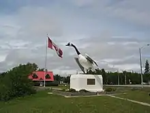
The community is known for its 8.5-metre (28-foot) metal statue of a Canada goose, which was built in 1960, and dedicated to the community in 1961. Wawa takes its name from the Ojibwe word for "wild goose", wewe. Wawa was defined as wild goose in The Song of Hiawatha. On July 5, 2010, Canada Post made a commemorative stamp of the Wawa Goose as part of its Roadside Attractions collection.[17] On July 1, 2017 a new Wawa Goose was unveiled to replace the second aging goose.[18]
The town is also known for snowmobiling and sport fishing. The Voyageur Hiking Trail passes through the town. One notable shopping location is Young's General Store, home of the locally famous Pickle Barrel.
Politics
The municipal council is composed of one mayor and four councillors. The current mayor is Ron Rody. Councillors Tamara Liddle, Bill Chiasson, James Neufeld and Yvan Besner were elected on October 27, 2014 for a four-year term. After James Neufeld resigned on April 27, 2015, Matthew Morrison was appointed to fill the vacant seat on August 10, 2015.[19][20] In 2016, Councillor Tamara Liddle and her husband, Gerry Liddle were investigated and it was revealed that both Gerry Liddle and Councillor Tamara Liddle harassed CAO Chris Wray in an effort to obtain a personal benefit to avoid paying municipal taxes/avoid enforcement of their municipal tax arrears. Both were sanctioned by town council.[21] After the 2018 municipal elections, Ron Rody was acclaimed as mayor and the following councillors were elected: Bill Chiasson, Mitch Hatfield, Robert Reece, and Pat Tait.[22]
Transportation
Highway 17, the main route of the Trans-Canada Highway, passes through the township, although the primary townsite is located on Highway 101, two kilometers east of the junction with Highway 17. Sault Ste. Marie is located 227 kilometers to the south. Lake Superior Provincial Park is located just south of the town.
In October 2012, the town was forced to declare a state of emergency after severe flooding washed out several roads within the municipality, including sections of both Highway 17 and Highway 101.[23]
Wawa is located 24 kilometres west of Canadian National Railway's Hawk Junction station on the rail line from Sault Ste. Marie to Hearst. The line, formerly known as the Algoma Central Railway, provides tourist operations, as well as passenger and freight service to communities in northern Ontario.
A dial-in/demand response transit system has been available since February 2006. The service is provided by a single bus that can accommodate 12 passengers plus up to two wheelchairs.[24]
Climate
Wawa has a humid continental climate (Köppen climate classification Dfb) that is significantly moderated by Lake Superior. Winters are cold and snowy with a January high of −7.7 °C (18.1 °F) and a low of −20.2 °C (−4.4 °F) and temperatures below −20 °C (−4.0 °F) occur 45 days per year.[2] Snowfall totals are heavy, averaging over 319 centimetres (126 in) due to lake effect snow from Lake Superior as cold air from the northwest passes over the warmer lake.[25] Summers are cool and mild due to cool, dry air masses from the northwest and the cooling of warm air from the south as it passes Lake Superior.[25][26] As a result, temperatures above 30 °C (86.0 °F) are rare.[2] August is the warmest month with a high of 20.8 °C (69.4 °F) and a low of 9.8 °C (49.6 °F), showing a slight seasonal lag. The average annual precipitation is 970 millimetres (38 in), which is relatively evenly distributed throughout the year though the months of July to October see a peak in precipitation.[2]
| Climate data for Wawa Airport (1981−2010) | |||||||||||||
|---|---|---|---|---|---|---|---|---|---|---|---|---|---|
| Month | Jan | Feb | Mar | Apr | May | Jun | Jul | Aug | Sep | Oct | Nov | Dec | Year |
| Record high humidex | 6.7 | 12.3 | 20.1 | 30.6 | 37.1 | 39.0 | 37.1 | 38.9 | 34.9 | 28.3 | 19.7 | 18.5 | 39.0 |
| Record high °C (°F) | 6.8 (44.2) |
11.5 (52.7) |
20.0 (68.0) |
30.3 (86.5) |
31.4 (88.5) |
30.7 (87.3) |
33.1 (91.6) |
34.1 (93.4) |
28.9 (84.0) |
28.0 (82.4) |
19.4 (66.9) |
15.5 (59.9) |
34.1 (93.4) |
| Average high °C (°F) | −7.7 (18.1) |
−5.4 (22.3) |
−0.2 (31.6) |
7.5 (45.5) |
14.6 (58.3) |
19.0 (66.2) |
20.9 (69.6) |
20.8 (69.4) |
16.6 (61.9) |
9.5 (49.1) |
2.2 (36.0) |
−4.5 (23.9) |
7.8 (46.0) |
| Daily mean °C (°F) | −14.0 (6.8) |
−11.9 (10.6) |
−6.5 (20.3) |
1.6 (34.9) |
8.1 (46.6) |
12.6 (54.7) |
15.1 (59.2) |
15.3 (59.5) |
11.4 (52.5) |
5.0 (41.0) |
−1.8 (28.8) |
−9.5 (14.9) |
2.1 (35.8) |
| Average low °C (°F) | −20.2 (−4.4) |
−18.3 (−0.9) |
−12.8 (9.0) |
−4.2 (24.4) |
1.5 (34.7) |
6.1 (43.0) |
9.2 (48.6) |
9.8 (49.6) |
6.1 (43.0) |
0.4 (32.7) |
−5.7 (21.7) |
−14.5 (5.9) |
−3.6 (25.5) |
| Record low °C (°F) | −40.9 (−41.6) |
−50.0 (−58.0) |
−37.1 (−34.8) |
−25.2 (−13.4) |
−9.4 (15.1) |
−3.4 (25.9) |
0.0 (32.0) |
0.7 (33.3) |
−5.2 (22.6) |
−13.0 (8.6) |
−26.0 (−14.8) |
−39.0 (−38.2) |
−50.0 (−58.0) |
| Record low wind chill | −51.1 | −44.6 | −43.6 | −30.1 | −12.4 | −2.8 | 0.0 | 0.0 | −6.9 | −13.1 | −31.9 | −46.1 | −51.1 |
| Average precipitation mm (inches) | 55.7 (2.19) |
46.9 (1.85) |
54.1 (2.13) |
66.9 (2.63) |
77.5 (3.05) |
82.2 (3.24) |
96.1 (3.78) |
92.5 (3.64) |
122.0 (4.80) |
117.5 (4.63) |
85.7 (3.37) |
72.5 (2.85) |
969.7 (38.18) |
| Average rainfall mm (inches) | 2.3 (0.09) |
5.3 (0.21) |
18.8 (0.74) |
47.0 (1.85) |
74.6 (2.94) |
82.2 (3.24) |
96.1 (3.78) |
92.5 (3.64) |
121.8 (4.80) |
107.0 (4.21) |
48.3 (1.90) |
12.0 (0.47) |
707.8 (27.87) |
| Average snowfall cm (inches) | 72.1 (28.4) |
55.8 (22.0) |
40.1 (15.8) |
18.4 (7.2) |
2.8 (1.1) |
0.0 (0.0) |
0.0 (0.0) |
0.0 (0.0) |
0.15 (0.06) |
9.7 (3.8) |
40.5 (15.9) |
79.8 (31.4) |
319.4 (125.7) |
| Average precipitation days (≥ 0.2 mm) | 17.0 | 14.1 | 11.9 | 10.5 | 12.4 | 12.8 | 13.2 | 13.3 | 15.3 | 15.6 | 16.1 | 17.6 | 169.8 |
| Average rainy days (≥ 0.2 mm) | 1.4 | 1.2 | 3.6 | 7.0 | 12.0 | 12.8 | 13.2 | 13.3 | 15.2 | 13.8 | 7.7 | 2.9 | 104.2 |
| Average snowy days (≥ 0.2 cm) | 16.7 | 14.0 | 9.6 | 5.1 | 0.83 | 0.0 | 0.0 | 0.0 | 0.23 | 3.3 | 11.2 | 16.7 | 77.7 |
| Source: Environment Canada[2] | |||||||||||||
People
Wawa is home to former NHL hockey players Chris Simon and Denny Lambert as well as comedian Pete Zedlacher.[27]
Representation in other media
- Most of the Canadian movie Snow Cake (2006) was filmed in Wawa.
The Canadian Film Brotherhood was filmed at Michipicoten First Nation and included cast members and crew from the First Nation and Wawa.
See also
References
- "Census Profile, 2016 Census: Wawa, Municipality". Statistics Canada. Retrieved June 9, 2019.
- "Wawa Airport". Canadian Climate Normals 1981–2010. Environment Canada. Retrieved December 17, 2013.
- "Annual changes to census subdivision codes, names and types, between 2006 and 2011, by province and territory, and by year". Standard Geographical Classification (SGC) 2011. Statistics Canada. Retrieved 2012-02-22.
- Morton, page 168: 1727, Losey,page 44:1725
- Arthur S Morton, A History of the Canadian West, no date
- Elizabeth Browne Losey, Let Them Be Remembered:The Story of the Fur Trade Forts, 1999
- Barnes, Michael (1995). Gold in Ontario. Erin: The Boston Mills Press. pp. 27–31. ISBN 155046146X.
- Special, 1971, June 29, "Small Time Mecca for Transient Youth", The Globe and Mail, p31
- "Prof. Kenneth (K. C. A.) Dawson, CD, MA". anthropology.lakeheadu.ca. Lakehead University. 2010-01-21. Retrieved 2011-08-25.
- "Catalogue Db query". catalogue.civilization.ca. Canadian Museum of Civilization.
- "2016 Community Profiles". 2016 Canadian Census. Statistics Canada. February 21, 2017. Retrieved 2019-06-09.
- "2011 Community Profiles". 2011 Canadian Census. Statistics Canada. July 5, 2013. Retrieved 2012-02-16.
- "2006 Community Profiles". 2006 Canadian Census. Statistics Canada. March 30, 2011. Retrieved 2011-04-15.
- "2001 Community Profiles". 2001 Canadian Census. Statistics Canada. February 17, 2012.
- Statistics Canada: 1996, 2001, 2006 census.
- "Wawa census profile". 2011 Census of Population. Statistics Canada. Retrieved 2012-02-16.
- Canada Post Stamp Details, July to September 2010, p 8, Volume XIX, No. 3
- "Wawa Goose is Unveiled!". Wawa News. Retrieved December 11, 2018.
- "Council to Appoint Matthew Morrison as New Councillor – Was Process Tainted?". Wawa News. 11 August 2015. Retrieved 12 July 2016.
- "Matthew Morrison Sworn in as New Councillor". Wawa News. 13 August 2015. Retrieved 12 July 2016.
- "Municipal Council Takes Action against Councillor Tamara & Gerry Liddle". Wawa News. August 10, 2016. Retrieved December 11, 2018.
- "Northern Ontario flooding may cause millions in damage". CTV News, October 27, 2012.
- "Transit Services". Municipality of Wawa. Retrieved 11 December 2018.
- "NATURAL PROCESSES IN THE GREAT LAKES". Us Environmental Protection Agency. 25 June 2012. Retrieved 30 September 2012.
- "Physical Geography of Ontario" (PDF). Retrieved 30 September 2012.
- Wawa Boy Hits It Big. The Algoma News, October 4, 2010.
External links
| Wikimedia Commons has media related to Wawa, Ontario. |
Places adjacent to Wawa, Ontario | |
|---|---|