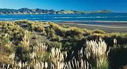
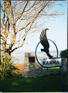
Kawhia Harbour
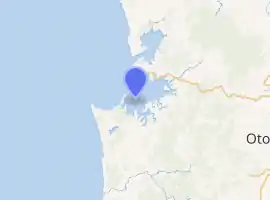
Kawhia Harbour (Maori: "Kāwhia") is one of three large natural inlets in the Tasman Sea coast of the Waikato region of New Zealand's North Island. It is located to the south of Raglan Harbour, Ruapuke and Aotea Harbour, 40 kilometres southwest of Hamilton. Kawhia is part of the Otorohanga District Council[1] and is in the King Country. It has a high-tide area of 68 km2 (26 sq mi) and a low-tide area of 18 km2 (6.9 sq mi).[2]
Kawhia | |
|---|---|
 Kawhia Beach | |
| |
| Coordinates: 38°6′S 174°48′E | |
| Country | |
| Region | Waikato region |
| Territorial authority | Ōtorohanga District |
| Ward | Kāwhia-Tihiroa |
| Electorate | Taranaki-King Country |
| Government | |
| • MP | Barbara Kuriger (National) |
| • Mayor | Max Baxter |
| Population (2018 census) | |
| • Urban | 384 |
| Time zone | UTC+12 (NZST) |
| • Summer (DST) | UTC+13 (NZDT) |
| Postcode | 2451 |
| Area code(s) | 07 |
The settlement of Kawhia is located on the northern coast of the inlet, and was an important port in early colonial New Zealand.[3] The area of Kawhia comprises 16 to 20 hectares (40 to 50 acres) and is the town block that was owned by the New Zealand Government. The government bought it from the Europeans in 1880 "not from the original Māori owners, but from a European who claimed ownership in payment of money owed by another European".[3]
In January 2018, the health board issued a statement that there was no additional risk from tuberculosis in Kawhia after reports of three possible cases.[4][5]
Te Motu Island is located inside the harbour.
History and culture
.jpg.webp)
Early history
Kawhia is known in Māori lore as the final resting-place of the ancestral waka (canoe) Tainui. Soon after arrival, captain Hoturoa made it first priority to establish a whare wananga (sacred school of learning) which was named Ahurei.[6] Ahurei is situated at the summit of the sacred hill behind Kawhia’s seaside marae – Maketu Marae. The harbour area was the birthplace of prominent Māori warrior chief Te Rauparaha of the Ngāti Toa tribe, who lived in the area until the 1820s, when he, and his tribe along with Ngāti Rārua and Ngāti Koata migrated southwards.
Tainui was buried at the base of Ahurei by Hoturoa himself, and other members of the iwi. Hoturoa marked out the waka with two limestone pillars which he blessed. Firstly, there is "Hani (Hani-a-te-waewae-i-kimi-atu) which is on the higher ground and marked the prow of the canoe".[7] Marking the stern of the canoe, Hoturoa placed the symbol of Puna, the spirit-goddess of that creation story. "In full it is named Puna-whakatupu-tangata, and represents female fertility, the spring or source of humanity".[6] It is said that a pure woman who touches this stone will be given the gift of a child, and become pregnant. There have been cases of women using Puna when they have had difficulty conceiving a child.
Marae
Maketu Marae is located next to Kawhia Harbour. The main meeting house of the marae, Auau ki te Rangi, is named after Hoturoa’s father who was a high chief (ariki) and was built and opened in 1962.[8]
The eldest and most prestigious meeting house that was first built on Maketu Marae is Te Ruruhi (the Old Lady) which was used as the dining hall until 1986. It was replaced by a two-storey dining hall, Te Tini O Tainui, to cater for the numerous numbers that visit for occasions such as annual poukai, tangi and hui.[9] The marae is affiliated with the Maniapoto hapū of Apakura and Hikairo, and the Waikato Tainui hapū of Ngāti Mahuta and Ngāti Te Weehi.[10]
Six other marae are also based at or near Kawhia Harbour:
- Mōkai Kainga Marae and Ko Te Mōkai meeting house is a meeting place for the Maniapoto hapū of Apakura and Hikairo, and the Waikato Tainui hapū of Apakura.
- Mokoroa Marae and Ngā Roimata meeting house is a meeting place for the Maniapoto hapū of Ngati Kiriwai.
- Ōkapu or Oakapu Marae and Te Kotahitanga o Ngāti Te Weehi meeting house is a meeting place for the Waikato Tainui hapū of Ngāti Mahuta and Ngāti Te Weehi.
- Te Māhoe Marae is a meeting ground for the Maniapoto hapū of Peehi, Te Kanawa, Te Urupare and Uekaha.
- Waipapa Marae and Ngā Tai Whakarongorua and Takuhiahia meeting houses are a meeting place for the Maniapoto hapū of Hikairo, and the Waikato Tainui hapū of Ngāti Hikairo and Ngāti Puhiawe.[8][10]
- Rākaunui Marae and Moana Kahakore meeting house is a meeting place for the Maniapoto hapū of Ngāti Ngutu, Ngāti Te Kiriwai, Ngāti Paretekawa and the Waikato Tainui hapū Ngāti Apakura.
In October 2020, the Government committed $196,684 from the Provincial Growth Fund to upgrade Ōkapu Marae, creating 16 jobs.[11]
Demographics
| Year | Pop. | ±% p.a. |
|---|---|---|
| 2006 | 897 | — |
| 2013 | 828 | −1.14% |
| 2018 | 966 | +3.13% |
| Source: [12] | ||
The statistical area of Pirongia Forest, which at 491 square kilometres is much larger than this town, had a population of 966 at the 2018 New Zealand census, an increase of 138 people (16.7%) since the 2013 census, and an increase of 69 people (7.7%) since the 2006 census. There were 393 households. There were 498 males and 468 females, giving a sex ratio of 1.06 males per female. The median age was 50.5 years (compared with 37.4 years nationally), with 189 people (19.6%) aged under 15 years, 117 (12.1%) aged 15 to 29, 417 (43.2%) aged 30 to 64, and 243 (25.2%) aged 65 or older.
Ethnicities were 64.3% European/Pākehā, 46.9% Māori, 3.1% Pacific peoples, 1.6% Asian, and 1.2% other ethnicities (totals add to more than 100% since people could identify with multiple ethnicities).
The proportion of people born overseas was 6.8%, compared with 27.1% nationally.
Although some people objected to giving their religion, 54.0% had no religion, 31.4% were Christian, and 5.3% had other religions.
Of those at least 15 years old, 81 (10.4%) people had a bachelor or higher degree, and 246 (31.7%) people had no formal qualifications. The median income was $19,700, compared with $31,800 nationally. The employment status of those at least 15 was that 270 (34.7%) people were employed full-time, 141 (18.1%) were part-time, and 39 (5.0%) were unemployed.[12]
Kawhia town had a population of 384 in the 2018 census, an increase of 48 from 2013. There were 198 males and 189 females.[13]
Before 2018, Kawhia was in its own statistical area[14]
| Year | Population | Households | Median age | Median income | National median |
|---|---|---|---|---|---|
| 2001 | 507 | 198 | 44.1 | $12,100 | $18,500 |
| 2006 | 390 | 171 | 49.2 | $15,100 | $24,100 |
| 2013 | 339 | 153 | 53.8 | $19,200 | $27,900 |
In 2013 there were 231 unoccupied dwellings. 57.7% of the population had Māori origins (far above the 14.9% national average), 56.7% European, 3.8% Pacific and 1% Asian. 5.9% were born overseas, well below the 25.2% average for the whole country.[15]
As of 2017, New Zealand's median centre of population is located around one kilometre off the coast of Kawhia.[16]
Te Puia Hot Springs
2 hours either side of low tide (for tide times see tide-forecast.com)[17] about 100m of the Tasman Sea beach, 4 km from Kawhia (see 1:50,000 map[18]), oozes hot water, which can be formed into shallow bathing pools with a spade.[19]
A council sample taken on 30 March 2006 listed these in the water.[20]
| Site | pH | Li | Na | K | Ca | Mg | Rb | Cl | SO4 | B | SiO2 | NH4 | HCO3 | S Total | F | Fe | 18OVSMOW | d2HVSMOW | Br |
|---|---|---|---|---|---|---|---|---|---|---|---|---|---|---|---|---|---|---|---|
| Te Puia | 7.9 | 9.21.71 | 3870 | 121 | 2150 | 107 | 0.094 | 9540 | 724 | 7.5 | 34.3 | 2.17 | 25 | 0.712 | 0.62 | 0.1 | -2.66 | -21.7 | 29.6 |
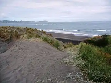 Te Puia Springs are on the beach to the right from this track across the dunes.
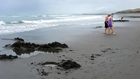 about 100 metres of beach oozes hot water, which is uncovered for about 4 hours at spring low tides, but not at neap tides.
Notable people
- John Kent, European trader, 1820s–1830s
- Cort and Annie Jane Schnackenberg, 1860s missionaries[21]
- Carole Shepheard (born 1945), artist
- Samuel Poriana Wall (born 1987), anaesthetist
- Stephen Wall (brother of Samuel Wall), general practitioner
Education
Kawhia School is a Year 1–8 co-educational state primary school.[22][23] It is a decile 1 school with a roll of 43 as of March 2020.[24][25]
References
- "2006 Census data".
- "Mapping residence times in west coast estuaries of the Waikato region". Waikato Regional Council. Retrieved 2017-12-14.
- "Kawhia Harbour History". Retrieved 18 April 2016.
- "No risk of Tuberculosis in Kawhia community | Waikato Newsroom". waikatodhbnewsroom.co.nz. Retrieved 2018-03-15.
- "Five confirmed cases of tuberculosis from Kawhia". Stuff. Retrieved 2018-01-21.
- "Kawhia Maori History". www.kawhia.maori.nz.
- Kawhia Harbour, para 15-16
- "Māori Maps". maorimaps.com. Te Potiki National Trust.
- "Waitomo Tourism Facts". waitomo.org.nz. Waitomo Tourism.
- "Te Kāhui Māngai directory". tkm.govt.nz. Te Puni Kōkiri.
- "Marae Announcements" (Excel). growregions.govt.nz. Provincial Growth Fund. 9 October 2020.
- "Statistical area 1 dataset for 2018 Census". Statistics New Zealand. March 2020. Pirongia Forest (185200). 2018 Census place summary: Pirongia Forest
- "Age and sex by ethnic group (grouped total response), for census usually resident population counts, 2006, 2013, and 2018 Censuses (urban rural areas)". Statistics New Zealand. Retrieved 20 November 2020.
- "2013 Census map – QuickStats about a place". archive.stats.govt.nz. Retrieved 2018-11-05.
- "2013 Census QuickStats about a place". archive.stats.govt.nz. Retrieved 2019-02-21.
- "Three in four New Zealanders live in the North Island | Stats NZ". www.stats.govt.nz. Retrieved 2021-01-12.
- "Tide Times and Tide Chart for Kawhia". www.tide-forecast.com.
- "Te Puia Springs, Waikato". NZ Topo Map. Retrieved 2020-01-13.
- http://www.nzhotpools.co.nz/hot-pools/kawhia-springs-te-puia-springs
- "Interpretation of Geochemical Data (REGEMP II) and Recommendations for Further Monitoring" (PDF). Environment Waikato. Archived from the original (PDF) on 30 June 2016.
- Hutching, Megan. "Annie Jane Schnackenberg". Dictionary of New Zealand Biography. Ministry for Culture and Heritage. Retrieved 16 March 2012.
- "Official School Website". kawhia.school.nz.
- Education Counts: Kawhia School
- "New Zealand Schools Directory". New Zealand Ministry of Education. Retrieved 26 April 2020.
- "Education Review Office Report". ero.govt.nz. Education Review Office.
