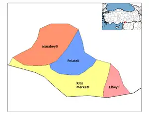
Kilis
Kilis is a city in south-central Turkey, near the border with Syria, and the administrative centre of Kilis Province.
Kilis | |
|---|---|
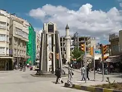 Kilis city center | |
 Kilis | |
| Coordinates: 36°43′N 37°07′E | |
| Country | Turkey |
| Province | Kilis |
| Government | |
| • Mayor | Mehmet Abdi Bulut (AKP) |
| • Kaymakam | Kadir Duman |
| Area | |
| • District | 575.18 km2 (222.08 sq mi) |
| Elevation | 660 m (2,170 ft) |
| Population (2015)[2] | |
| • Urban | 93,266 |
| • District | 106,293 |
| • District density | 180/km2 (480/sq mi) |
| Post code | 79000 |
| Website | www.kilis.bel.tr |
History
.jpg.webp)
.jpg.webp)
Although there are not any definite information related to its foundation, today's Kilis City mainly developed and became urbanized during the Ottoman Period. However, traces of important cities found in the near surroundings of Kilis and the historical documents prove that important centres were always present here in every period. In the tablets belonging to the Assyrian period, the name 'Ki-li-zi' is written in cuneiform and a city named as "Ciliza Sive Urnagiganti" during the Roman Empire period is mentioned.
In addition to centers such as Kirus antique city, Oylum Höyük, Ravanda Castle, Ilezi and Tarzime Han, many other residential areas starting from the Neolithic period have also been discovered in the surrounding of Kilis as a result of archaeological surface explorations. Hittite, Greek, Persian, Roman, Byzantine, Crusader, Mamluk and Ottoman periods were experienced in the region respectively.
As a result of the researchers, it has been determined that the 2 oldest structures (Ulu Mosque, 1388 and Katrancı Mosque, 1460) in the city center of Kilis belong to the Mamluk Period. Besides these two mosques approximately 135 monumental structures have being constructed since 1516 during the Ottoman Period.
The population of Kilis was 20.000 and it was a city in which production, commerce and cultural functions were developed at the end of the 19th century and it was also a center in which agricultural products (such as grapes, cereals etc.) cultivated in nearly 500 villages around it was processed and industrial products were produced and marketed.
As in the whole Ottoman geography, members of the three major religions are living here together and culture and art are highly developed. 37 mosques, 14 small mosques, 4 Dervish Lodges, 8 madrasahs, 4 churches, 1 synagogue, 31 fountains, 5 Turkish baths, 40 coffee houses, 5 pharmacies and 5 drinking houses that were present in the city at the end of the 19th century give information about the social and cultural structure here. Poetry, music and handicrafts and especially architecture was developed.
Kilis was part of the Aleppo Vilayet of the Ottoman Empire until the First World War, after which it passed to the Republic of Turkey. There was also an Armenian and Jewish community.[3] The sizable Armenian population was persecuted and eventually massacred during the Armenian Genocide.
Being a border town, Kilis has long had a reputation for smuggling and drug trafficking. Although this has apparently been reduced, even today cigarettes, spirits and cheap electrical items can be bought for cash at low prices. During the Syrian Civil War, the city became a target of continuous rocket attacks by ISIL. in April 2016, the town was struck by rockets fired by ISIS killing 21 people and injuring others.[4][5]
During the Ayyubid era, the Kurdish dynasty of Mand, or Mantashah, commenced.[6] Mand, who allegedly traced his ancestry back to Abbas, had initially been given control of Qusayr, thereafter also of Joum and Kilis. His descendants would continue to rule Kilis, though at times interrupted, until Ottoman times. Their last representative was Hussain Janpoulad, who was killed in 1610. Thereafter, remaining members of the Janpoulad family fled to Lebanon, intermarried with the Druze, and became the Jumblatt family.[7]
Population
The population of the town was 20,000 in 1927, 45,000 in 1970, 60,000 in 1980 and 85,000 in 1990. It then fell in the 1990s to 70,000 by 2000. The population was 82,109 in 2010.
Geography
Kilis is surrounded by three important cities named Gaziantep, Antakya and Aleppo, in the region in which the Anatolia Plateau ends and the Syria plain begins. As a result of its proximity to the North Mediterranean, it is in a transition region between the Mediterranean climate and the continental climate.It is in the Northwestern part of the Mesopotamia region name as the "Fertile Crescent", which has been a settling area since the very beginning of history.
The Öncüpınar Syrian border crossing is 5 km (3 mi) to the south and the large city of Gaziantep is 60 km (37 mi) to the north. Indeed, until 1996 Kilis was a district of Gaziantep Province, being made into a province by Tansu Çiller following an open vote-winning gambit in the 1995 general election.
Architecture
The city in which traditional stone architecture is dominant, has an organic structure. Narrow streets, stone walls and houses with courtyards inside create the structure of the city together with the monumental buildings. The houses of Kilis are shaped depending on the effects of the climate and cultural approaches and are not easily detected from outside as they are surrounded with high walls. You can see the houses as places located around large courtyards when you enter through the door that opens to the street or dead-end street.
Cuisine
The local kebab known as Kilis Tava is renowned, and also the breads, baklava, künefe and stuffed vegetables.
Education
Kilis 7 Aralık University is located in Kilis and has around 8,000 undergraduate and graduate students.
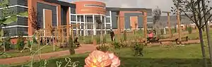 Kilis 7 Aralık University |
Places of interest
Sights in the town include a number of Ottoman era mosques and stone houses with courtyards and elaborate carved wooden fittings.
Mosques
- Canbolat or Tekke, built in the 16th century.[8]
- Muallak, built in the 16th century.[8]
- Hacı Derviş, built in 1551.[8]
- Şeyhler or Şeyh Süleyman, built in 1655.[8]
- Hindioğlu, built in 1664.[8]
- Akcurun, built in the 16th or 17th century.[8]
- Şeyh, built in 1569.[8]
- Şeyh Hilal, the minaret was built in 1641.[8]
- Katrancı or Alacalı, the present structure was rebuilt in 1962.[8]
- Murtaza, built in 1659 repaired in 1948.[8]
- Cüneyne, built in 1569.[8]
Mausoleums (Türbe)
- The Mausoleum of Sheikh Mansur
- The Mausoleum of Sheikh Muhammed Bedevi (Rıttali)
- The Mausoleum of Sheikh Muhammed Ensari
Dervish Lodges (Tekke)
- Shurahbil bin Hasanah Dervish Lodge and Mausoleum
Turkish Baths (Hamam)
- Old (Eski) Baths
- Paşa Baths
- Tuğlu (Daltaban Pasha) Baths
Climate
Kilis has a hot summer Mediterranean climate (Köppen climate classification Csa), with very hot, dry and long summers and cool and rainy winters, with occasional snowfall.
| Climate data for Kilis | |||||||||||||
|---|---|---|---|---|---|---|---|---|---|---|---|---|---|
| Month | Jan | Feb | Mar | Apr | May | Jun | Jul | Aug | Sep | Oct | Nov | Dec | Year |
| Record high °C (°F) | 20.9 (69.6) |
22.5 (72.5) |
28.8 (83.8) |
35.4 (95.7) |
40.2 (104.4) |
41.0 (105.8) |
44.2 (111.6) |
45.0 (113.0) |
41.4 (106.5) |
36.4 (97.5) |
29.6 (85.3) |
25.7 (78.3) |
45.0 (113.0) |
| Average high °C (°F) | 9.7 (49.5) |
11.4 (52.5) |
15.9 (60.6) |
21.2 (70.2) |
27.3 (81.1) |
32.6 (90.7) |
36.0 (96.8) |
36.0 (96.8) |
32.6 (90.7) |
26.3 (79.3) |
17.8 (64.0) |
11.4 (52.5) |
23.2 (73.7) |
| Average low °C (°F) | 2.2 (36.0) |
3.1 (37.6) |
6.0 (42.8) |
10.0 (50.0) |
14.4 (57.9) |
18.4 (65.1) |
21.2 (70.2) |
21.2 (70.2) |
18.6 (65.5) |
14.3 (57.7) |
8.2 (46.8) |
3.8 (38.8) |
11.8 (53.2) |
| Record low °C (°F) | −11.0 (12.2) |
−8.4 (16.9) |
−6.8 (19.8) |
−1.3 (29.7) |
5.4 (41.7) |
10.0 (50.0) |
14.6 (58.3) |
13.2 (55.8) |
10.2 (50.4) |
1.5 (34.7) |
−3.5 (25.7) |
−8.0 (17.6) |
−11.0 (12.2) |
| Average precipitation mm (inches) | 84.8 (3.34) |
73.7 (2.90) |
69.2 (2.72) |
49.9 (1.96) |
25.5 (1.00) |
7.4 (0.29) |
1.2 (0.05) |
2.8 (0.11) |
5.9 (0.23) |
33.8 (1.33) |
58.4 (2.30) |
88.1 (3.47) |
500.7 (19.7) |
| Average rainy days | 12 | 11 | 11 | 9 | 6 | 2 | 0 | 0 | 2 | 5 | 8 | 12 | 78 |
| Average relative humidity (%) | 71 | 69 | 63 | 60 | 52 | 40 | 34 | 35 | 43 | 54 | 64 | 70 | 55 |
| Mean monthly sunshine hours | 130.2 | 140.0 | 195.3 | 231.0 | 288.3 | 339.0 | 359.6 | 344.1 | 300.0 | 235.6 | 168.0 | 120.9 | 2,852 |
| Source 1: Devlet Meteoroloji İşleri Genel Müdürlüğü | |||||||||||||
| Source 2: Weather2 | |||||||||||||
References
- "Area of regions (including lakes), km²". Regional Statistics Database. Turkish Statistical Institute. 2002. Retrieved 2013-03-05.
- "Population of province/district centers and towns/villages by districts - 2012". Address Based Population Registration System (ABPRS) Database. Turkish Statistical Institute. Retrieved 2013-02-27.
- p. 40.
- ABC News Australia: "Four dead as rockets hit teachers' dormitory in Turkish town of Kilis near Syria border" 18 Apr 2016
- Reuters: "Anger, fear sweeps Turkish border town under attack from Islamic State" BY HUMEYRA PAMUK May 16, 2016
- Şerefxanê Bedlîsî. Şerefname: Dîroka Kurdistanê. Translated by Z. Avci. Viranşehir: Azad, 2014.
- Ágoston G., and Bruce A. Masters, Encyclopedia of the Ottoman Empire (New York, 2008).
- T.A. Sinclair (31 December 1990). Eastern Turkey: An Architectural & Archaeological Survey, Volume IV. Pindar Press. pp. 114–119. ISBN 978-1-904597-79-7.
External links
| Wikimedia Commons has media related to Kilis. |