Koukdjuak River
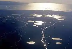
The Koukdjuak River begins at the outlet of Nettilling Lake and empties into the Arctic Ocean. It is the namesake of the Great Plain of the Koukdjuak located in the Foxe Basin on western Baffin Island, Nunavut (formerly Northwest Territories), northern Canada.
| Koukdjuak River | |
|---|---|
 | |
| Location | |
| Country | Canada |
| Territory | Nunavut |
| Physical characteristics | |
| Source | Nettilling Lake |
| • location | Southern Baffin Island |
| • coordinates | 66°34′48″N 71°21′23″W |
| • elevation | 92 ft (28 m)[1] |
| Mouth | Foxe Basin |
• coordinates | 66°44′30″N 73°03′21″W |
• elevation | 0 ft (0 m)[2] |
The first non-Inuit who specifically explored the river was the Canadian Arctic explorer/ornithologist, J. Dewey Soper. The northern boundary of the Dewey Soper Migratory Bird Sanctuary is the middle thread of the Koukdjuak River. The river is also notable as a Barren-ground caribou migration crossing and for Arctic charr fishing.[3]
See also
References
- Source elevation derived from Google Earth.
- Mouth elevation derived from Google Earth.
- "Migratory Bird Sanctuary Regulations". canlii.org. Retrieved 2008-01-21.
Further reading
- Kraft, Paul G. Caribou Tagging on the Koukdjuak River, Baffin Island, N.W.T. A Summary and Analysis of Tag Returns. Yellowknife: N.W.T. Wildlife Service, 1984. ISBN 0-7708-7140-2
- Kristofferson, A. H., R. D. Sopuck, and D. K. McGowan. Commercial Fishing Potential for Searun Arctic Charr, Koukdjuak River and Nettilling Lake, Northwest Territories. Canadian manuscript report of fisheries and aquatic sciences, no. 2120. Winnipeg: Fisheries and Oceans Canada, 1991.
| Core topics | ||
|---|---|---|
| Kitikmeot Region | ||
| Kivalliq Region | ||
| Qikiqtaaluk Region | ||
| National Parks | ||
| Territorial Parks |
| |
| ||
This article is issued from Wikipedia. The text is licensed under Creative Commons - Attribution - Sharealike. Additional terms may apply for the media files.