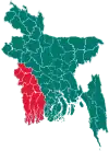
Koyra Upazila
Koyra (Bengali: কয়রা) is an upazila of the Khulna District of Bangladesh.[1] It's the 2nd largest Upazila in Bangladesh.
Koyra
কয়রা | |
|---|---|
 Koyra Location in Bangladesh | |
| Coordinates: 22°20.5′N 89°18′E | |
| Country | |
| Division | Khulna Division |
| District | Khulna District |
| Thana | 19 November 1979 |
| Upazila | 7 November 1983 |
| Government | |
| • MP (Khulna-6) | Akhteruzzaman Babu |
| • Upazila Chairman | SM Shafiqul Islam |
| Area | |
| • Total | 1,775.41 km2 (685.49 sq mi) |
| Population (1991) | |
| • Total | 165,473 |
| • Density | 93/km2 (240/sq mi) |
| Time zone | UTC+6 (BST) |
| Postal code | 9290 |
| Website | koyra |
_-_panoramio.jpg.webp)
History
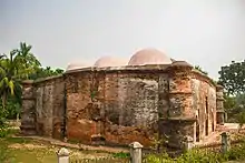
Koyra's history most likely dates as far back as the office of Khan Jahan Ali in the 15th century at least. This is evident from the ancient mosques found in Koyra such as Masjidkur.
The Channir Chak L.C. Collegiate School was established in 1935. In 1962, the Koyra Madinabad Secondary School was established.
During the Bangladesh Liberation War of 1971, a sub-sector of Sector 9 was founded in Koyra's Amati Union known as Bachharbari-Manoranjan Camp, and so most of the Mukti Bahini's and Mujib Bahini's operations were launched from here. The Bengali freedom fighters built five camps in Koyra; World Poet Camp led by Abd al-Latif, Najmul Camp led by KM Mujibur Rahman, Nazrul Camp led by Abd al-Hakim, Narayan Camp led by Keramat Ali, Shaykh Abd al-Jalil and Shamsur Rahman in Jhileghata and the Suhrawardy Camp led by Rezaul Karim in Bamiya, Bagali Union. In Jaygirmahal, Dr Rafiqul Islam ran a secret medical centre to provide treatment to wounded freedom fighters. A mass grave was found in Launch Ghat, Marighata.
On 19 November 1979, Korya was established as a thana.[2] It was upgraded to an upazila (sub-district) on 7 November 1983.[1]
The Upazila suffered heavy damage following the Cyclone Sidr in 2007 and Cyclone Aila two years after that.
Geography
Koyra is located at 22.3417°N 89.3000°E. It has 28,061 households and a total area 1775.41 km2.
Demographics
According to the 1991 Bangladesh census, Koyra had a population of 165,473. Among them 49.68% were male and 50.32%were female. The population aged 18 or over was 80,830. Koyra had an average literacy rate of 32.4% (7+ years), compared to the national average of 32.4%.[3]
The Upazila is home to Bengali Muslims, Bengali Hindus in addition to some other ethnic groups such as the Mahato and the Munda people who reside in the Koyra and Bedkashi unions.[2]
Administration
Koyra Upazila is divided into seven union parishads: Amadi, Bagali, Dakshin Bedkashi, Koyra, Moharajpur, Moheswaripur, and Uttar Bedkashi. The union parishads are subdivided into 71 mauzas and 133 villages.[4]
List of chairmen
| Name |
|---|
| Shams ad-Din Ahmad |
| AKM Tamiz ad-Din |
| GM Muhsin Reza |
| Nasima Alam |
| SM Shafiqul Islam |
Facilities
The upazila has three orphanages: Haji Rahim Orphanage, Qadi Kabir ad-Din Orphanage and Haji Qamar ad-Din Orphanage.
Notable people
- Ruman Shana, archer
- Shah Md. Ruhul Quddus, politician
References
- Md Ashraful Islam Goldar (2012). "Koyra Upazila". In Islam, Sirajul; Miah, Sajahan; Khanam, Mahfuza; Ahmed, Sabbir (eds.). Banglapedia: the National Encyclopedia of Bangladesh (Online ed.). Dhaka, Bangladesh: Banglapedia Trust, Asiatic Society of Bangladesh. ISBN 984-32-0576-6. OCLC 52727562. Retrieved 23 January 2021.
- এক নজরে কয়রা [Koyra at a glance]. Koyra Upojela (in Bengali).
- "Population Census Wing, BBS". Archived from the original on 2005-03-27. Retrieved November 10, 2006.
- "District Statistics 2011: Khulna" (PDF). Bangladesh Bureau of Statistics. Archived from the original (PDF) on 13 November 2014. Retrieved 14 July 2014.
Capital: Khulna | ||
| Upazilas/Thanas | ||
| Constituencies | ||
| Attractions and sites | ||
| Education | ||