L'Île-Cadieux
L'Île-Cadieux is a village and municipality in the Montérégie region of Quebec, Canada, part of the Vaudreuil-Soulanges Regional County Municipality. It is located on and contiguous with Cadieux Island, which projects into Lake of Two Mountains just north off Vaudreuil-sur-le-Lac. The population as of the Canada 2011 Census was 105.
L'Île-Cadieux | |
|---|---|
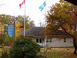 Town hall | |
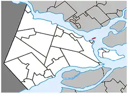 Location within Vaudreuil-Soulanges RCM | |
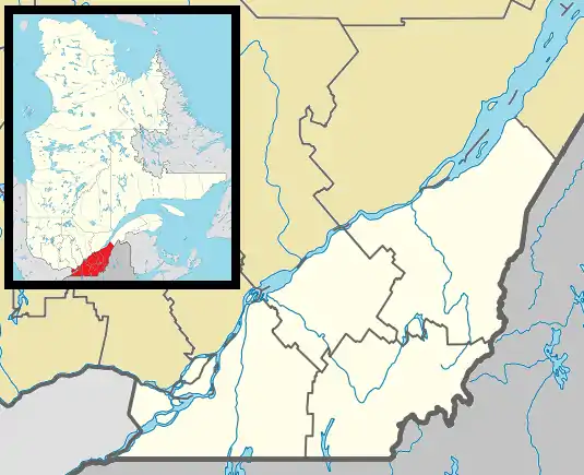 L'Île-Cadieux Location in southern Quebec | |
| Coordinates: 45°26′N 74°01′W[1] | |
| Country | |
| Province | |
| Region | Montérégie |
| RCM | Vaudreuil-Soulanges |
| Constituted | March 21, 1922 |
| Government | |
| • Mayor | Daniel Martel |
| • Federal riding | Vaudreuil-Soulanges |
| • Prov. riding | Vaudreuil |
| Area | |
| • Total | 8.90 km2 (3.44 sq mi) |
| • Land | 0.57 km2 (0.22 sq mi) |
| Population (2011)[4] | |
| • Total | 105 |
| • Density | 185.2/km2 (480/sq mi) |
| • Pop 2006-2011 | |
| • Dwellings | 59 |
| Time zone | UTC−5 (EST) |
| • Summer (DST) | UTC−4 (EDT) |
| Postal code(s) | J7V 8P3 |
| Area code(s) | 450 and 579 |
| Highways | No major routes |
| Website | www |
History
The island was formerly known as Vaudreuil Island but was named "Île à Cadieu" in an unpublished document of the second half of the nineteenth century. This name could be a reference to one of two Cadieux, Pierre and Hyacinthe, who owned land in the first concession along the Cove of Vaudreuil at that time.[5]
In 1922, the municipality was formed by separating from the Parish Municipality of Saint-Michel-de-Vaudreuil.[5]
Demographics
Population
| Canada census – L'Île-Cadieux community profile | |||
|---|---|---|---|
| 2011 | 2006 | ||
| Population: | 105 (-18.0% from 2006) | 128 (+0.8% from 2001) | |
| Land area: | 0.57 km2 (0.22 sq mi) | 0.57 km2 (0.22 sq mi) | |
| Population density: | 185.2/km2 (480/sq mi) | 225.7/km2 (585/sq mi) | |
| Median age: | 57.1 (M: 60.0, F: 54.2) | 54.2 (M: 56.3, F: 52.8) | |
| Total private dwellings: | 59 | 62 | |
| Median household income: | $.N/A | $.N/A | |
| Notes: Income data for this area has been suppressed for data quality or confidentiality reasons. – References: 2011[6] 2006[7] earlier[8] | |||
|
|
|
Language
| Canada Census Mother Tongue - L'Île-Cadieux, Quebec[9] | ||||||||||||||||||
|---|---|---|---|---|---|---|---|---|---|---|---|---|---|---|---|---|---|---|
| Census | Total | French |
English |
French & English |
Other | |||||||||||||
| Year | Responses | Count | Trend | Pop % | Count | Trend | Pop % | Count | Trend | Pop % | Count | Trend | Pop % | |||||
2011 |
105 |
60 | 57.14% | 25 | 23.81% | 0 | 0.00% | 20 | 19.05% | |||||||||
2006 |
125 |
50 | 40.00% | 45 | 36.00% | 0 | 0.00% | 30 | 24.00% | |||||||||
2001 |
125 |
95 | 76.00% | 15 | 12.00% | 0 | 0.00% | 15 | 12.00% | |||||||||
1996 |
120 |
65 | n/a | 54.17% | 20 | n/a | 16.67% | 0 | n/a | 0.00% | 35 | n/a | 29.17% | |||||
Schools
Commission Scolaire des Trois-Lacs operates Francophone schools.[10] It is zoned to École Saint-Michel and École Sainte-Madeleine in Vaudreuil-Dorion.[11]
Lester B. Pearson School Board operates Anglophone schools. It is zoned to Mount Pleasant Elementary School in Hudson.[12]
See also
References
- Reference number 177367 of the Commission de toponymie du Québec (in French)
- "Ministère des Affaires municipales, des Régions et de l'Occupation du territoire: L'Île-Cadieux". Archived from the original on 2015-12-08. Retrieved 2012-03-11.
- "Parliament of Canada Federal Riding History: VAUDREUIL--SOULANGES (Quebec)". Archived from the original on 2009-06-18. Retrieved 2009-03-25.
- 2011 Statistics Canada Census Profile: L'Île-Cadieux, Quebec
- "L'Île-Cadieux (Ville)" (in French). Commission de toponymie du Québec. Retrieved 2009-02-05.
- "2011 Community Profiles". 2011 Canadian Census. Statistics Canada. July 5, 2013. Retrieved 2013-05-19.
- "2006 Community Profiles". 2006 Canadian Census. Statistics Canada. March 30, 2011. Retrieved 2013-05-19.
- "2001 Community Profiles". 2001 Canadian Census. Statistics Canada. February 17, 2012.
- Statistics Canada: 1996, 2001, 2006, 2011, 2016 census
- "Les écoles et les centres". Commission Scolaire des Trois-Lacs. Retrieved 18 January 2013.
- "Liste des bassins desservis par les écoles en 2017-2018." Commission Scolaire des Trois-Lacs. Retrieved on September 30, 2017.
- "School Board Map." Lester B. Pearson School Board. Retrieved on September 28, 2017.
| Wikimedia Commons has media related to L'Île-Cadieux. |
Adjacent Municipal Subdivisions | |
|---|---|
| Cities & towns | |
|---|---|
| Municipalities | |
| Villages | |
| |