Landak Regency
Landak Regency is a regency of West Kalimantan province, Indonesia. It covers 9909.10 km2 and had a population of 329,649 at the 2010 Census;[2] the latest official estimate (as at mid 2019) is 377,305. The principal town lies at Ngabang. Landak is also one of the four regencies in West Kalimantan which is predominantly Catholic, the others being Sanggau, Sekadau, and Sintang.
Landak Regency
Kabupaten Landak | |
|---|---|
 Rombo Dait Waterfall | |
 Coat of arms | |
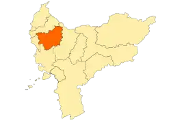 Location within West Kalimantan | |
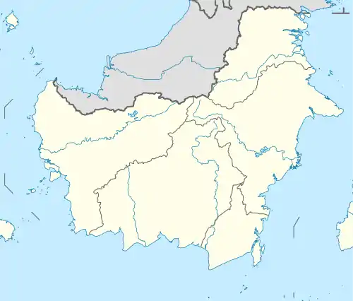 Landak Regency Location in Kalimantan and Indonesia  Landak Regency Landak Regency (Indonesia) | |
| Coordinates: 0.4237°N 109.7592°E | |
| Country | Indonesia |
| Province | West Kalimantan |
| Capital | Ngabang |
| Government | |
| • Regent | Karolin Margret Natasa |
| • Vice Regent | Herculanus Heriyadi |
| Area | |
| • Total | 9,909.10 km2 (3,825.92 sq mi) |
| Population (2019)[1] | |
| • Total | 377,305 |
| • Density | 38/km2 (99/sq mi) |
| Time zone | UTC+7 (IWST) |
| Area code | (+62) 563 |
| Website | landakkab |
Administrative Districts
Landak Regency consists of thirteen districts (kecamatan), tabulated below with their areas and their populations at the 2010 Census,[3] together with the latest official estimates (for mid 2019).[4] The table also includes the number of administrative villages (rural desa and urban keluraham) in each district and its post code.
| Name | Area in km2 | Pop'n Census 2010 | Pop'n Estimate mid 2019 | No. of vill. | Post code |
|---|---|---|---|---|---|
| Sebangki | 885.60 | 16,653 | 18,434 | 5 | 79358 |
| Ngabang | 1,148.10 | 60,583 | 84,395 | 6 | 79354 |
| Jelimpo | 848.80 | 23,338 | 25,595 | 13 | 79357 |
| Sengah Temila | 1,963.00 | 53,493 | 57,443 | 14 | 79456 |
| Mandor | 455.10 | 28,387 | 33,342 | 17 | 79355 |
| Menjalin | 322.90 | 18,598 | 20,304 | 8 | 79362 |
| Mempawah Hulu (Upper Mempawah) | 496.34 | 32,782 | 35,160 | 17 | 79363 |
| Sompak | 219.76 | 13,581 | 14,965 | 7 | 79361 |
| Menyuke | 594.16 | 25,716 | 26,067 | 16 | 79360 |
| Banyuke Hulu (Upper Banyuke) | 273.80 | 11,864 | 13,343 | 7 | 79364 |
| Meranti | 372.34 | 9,080 | 9,634 | 6 | 79366 |
| Kuala Behe | 968.00 | 13,650 | 14,486 | 11 | 79367 |
| Air Besar | 1,361.20 | 21,924 | 24,137 | 16 | 79365 |
| Totals | 9,909.10 | 329,649 | 377,305 | 156 |
Climate
Ngabang, the seat of the regency has a tropical rainforest climate (Af) with heavy rainfall year-round.
| Climate data for Ngabang | |||||||||||||
|---|---|---|---|---|---|---|---|---|---|---|---|---|---|
| Month | Jan | Feb | Mar | Apr | May | Jun | Jul | Aug | Sep | Oct | Nov | Dec | Year |
| Average high °C (°F) | 30.2 (86.4) |
30.7 (87.3) |
31.2 (88.2) |
31.7 (89.1) |
32.0 (89.6) |
31.7 (89.1) |
31.7 (89.1) |
31.7 (89.1) |
31.5 (88.7) |
31.4 (88.5) |
30.9 (87.6) |
30.6 (87.1) |
31.3 (88.3) |
| Daily mean °C (°F) | 26.3 (79.3) |
26.7 (80.1) |
26.9 (80.4) |
27.3 (81.1) |
27.5 (81.5) |
27.2 (81.0) |
27.1 (80.8) |
27.1 (80.8) |
27.0 (80.6) |
27.0 (80.6) |
26.7 (80.1) |
26.6 (79.9) |
27.0 (80.5) |
| Average low °C (°F) | 22.4 (72.3) |
22.7 (72.9) |
22.7 (72.9) |
22.9 (73.2) |
23.0 (73.4) |
22.7 (72.9) |
22.5 (72.5) |
22.5 (72.5) |
22.6 (72.7) |
22.7 (72.9) |
22.6 (72.7) |
22.6 (72.7) |
22.7 (72.8) |
| Average rainfall mm (inches) | 279 (11.0) |
237 (9.3) |
233 (9.2) |
288 (11.3) |
239 (9.4) |
193 (7.6) |
173 (6.8) |
196 (7.7) |
246 (9.7) |
304 (12.0) |
313 (12.3) |
314 (12.4) |
3,015 (118.7) |
| Source: Climate-Data.org[5] | |||||||||||||
References
- Badan Pusat Statistik, Jkarta, 2020.
- Biro Pusat Statistik, Jakarta, 2011.
- Biro Pusat Statistik, Jakarta, 2011.
- Badan Pusat Statistik, Jakarta, 2020.
- "Climate: Ngabang". Climate-Data.org. Retrieved 24 November 2020.
Regencies and cities of West Kalimantan | ||
|---|---|---|
Capital: Pontianak | ||
| Regencies | ||
| Cities | ||
