Kapuas Hulu Regency
Kapuas Hulu Regency (Upper Kapuas River) is a regency (kabupaten) of the West Kalimantan province of Indonesia. The region is home to a diverse number of indigenous groups, including the Iban and the Silat. Towns along the Kapuas River include Sintang, Nanga Lebang, Nanga Ketungau, Nanga Silat, Semitau, Nanga Bunut, and Putussibau, the regency's administrative centre. It covers an area of 29,842 km2, and had a population of 222,160 at the 2010 Census;[2] the latest official estimate (for mid 2017) is 254,712.[3]
Kapuas Hulu Regency
Kabupaten Kapuas Hulu | |
|---|---|
 Coat of arms | |
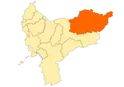 Location within West Kalimantan | |
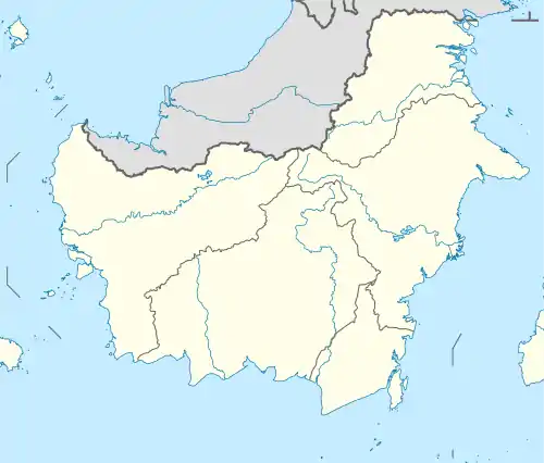 Kapuas Hulu Regency Location in Kalimantan and Indonesia  Kapuas Hulu Regency Kapuas Hulu Regency (Indonesia) | |
| Coordinates: 0.8167°N 112.7667°E | |
| Country | Indonesia |
| Province | West Kalimantan |
| Capital | Putussibau |
| Government | |
| • Regent | A.M. Nasir |
| • Vice Regent | Antonius L. Ain Pamero |
| Area | |
| • Total | 29,842 km2 (11,522 sq mi) |
| Population (2017)[1] | |
| • Total | 254,712 |
| • Density | 8.5/km2 (22/sq mi) |
| Time zone | UTC+7 (IWST) |
| Area code | (+62) 567 |
| Website | kapuashulukab |
Administrative districts
The Kapuas Hulu Regency consists of twenty-three districts (kecamatan), tabulated below with their areas and their 2010 Census populations,[4] together with the latest (mid 2017) official estimates of population. [5] populations. The table includes the number of administrative villages (rural desa and urban kelurahan) in each district, and its post code. Two further districts (Hulu Kapuas and Danau Sentarum) which existed in 2010 were subsequently merged with other districts (see Notes below table).
| Name | Area in km2 | Pop'n Census 2010 | Pop'n Estimate mid 2017 | No. of vill. | Post code |
|---|---|---|---|---|---|
| Silat Hilir (Lower Silat) | 1,177.10 | 16,987 | 20,303 | 13 | 78773 |
| Silat Hulu (Upper Silat) | 1,061.80 | 10,735 | 11,803 | 14 | 78774 |
| Hulu Gurung | 432.90 | 12,339 | 13,198 | 15 | 78764 |
| Bunut Hulu (Upper Bunut) | 1,118.14 | 12,889 | 15,372 | 15 | 78772 |
| Mentebah | 781.26 | 8,905 | 10,515 | 8 | 78757 |
| Bika | 395.16 | 4,228 | 4,230 | 8 | 78753 |
| Kalis | 1,857.84 | 11,764 | 15,079 | 17 | 78756 |
| Putussibau Selatan(a) (South Putussibau) | 5,352.30 | 12,838 | 22,926 | 16 | 78714 |
| Embaloh Hilir (Lower Embaloh) | 786.30 | 5,369 | 5,371 | 9 | 78754 |
| Bunut Hilir (Lower Bunut) | 844.10 | 8,434 | 8,436 | 11 | 78761 -78762 |
| Boyan Tanjung | 824.00 | 10,283 | 13,593 | 16 | 78758 |
| Pengkadan (Batu Datu) | 531.20 | 7,959 | 8,296 | 11 | 78759 |
| Jongkong | 422.50 | 9,907 | 10,696 | 14 | 78763 |
| Selimbau(b) | 1,153.88 | 10,118 | 14,694 | 17 | 78765 |
| Suhaid | 465.91 | 8,112 | 8,642 | 11 | 78775 |
| Seberuang | 573.80 | 10,314 | 10,978 | 15 | 78772 |
| Semitau | 562.70 | 7,992 | 9,441 | 12 | 78771 |
| Empanang | 547.14 | 2,858 | 3,006 | 6 | 78768 |
| Puring Kencana | 258.66 | 2,214 | 2,216 | 6 | 78769 |
| Badau | 700.00 | 5,203 | 5,501 | 9 | 78767 |
| Badang Lupar | 1,332.90 | 4,552 | 4,575 | 10 | 78766 |
| Embaloh Hulu (Upper Embaloh) | 3,457.60 | 4,675 | 4,680 | 10 | 78755 |
| Putussibau Utara (North Putussibau) | 5,204.80 | 23,737 | 31,161 | 19 | 78716 |
| Totals | 298,841.99 | 222,160 | 254,712 | 282 |
Notes: (a) at the 2010 Census, the Putussibau Selatan District only included the town of Putussibau, and covered 98.6 km2; the much larger district of Hulu Kapuas (with only 5,880 inhabitants in 2010), lying to the east of the town, was subsequently merged with the town to form a greatly enlarged Putussibau Selatan District.
(b) at the 2010 Census, the Selimbau District only included the southern half of the present district; the District of Danau Sentarum (with 3,868 inhabitants in 2010), lying to the north, was subsequently merged with it.
References
- Badan Pusat Statistik, Jakarta, 2020.
- Biro Pusat Statistik, Jakarta, 2011.
- Badan Pusat Statistik, Jakarta, 2020.
- Biro Pusat Statistik, Jakarta, 2011.
- Badan Pusat Statistik, Jakarta, 2020.
Regencies and cities of West Kalimantan | ||
|---|---|---|
Capital: Pontianak | ||
| Regencies | ||
| Cities | ||