Bengkayang Regency
Bengkayang Regency (Chinese: 孟嘉影) is a regency ("kabupaten") in West Kalimantan Province of Indonesia, (on the island of Borneo). It was originally a part of Sambas Regency, but following the expansion of the population in that area, Sambas Regency was divided into Sambas Regency and Bengkayang Regency in 1999, and Singkawang City was subsequently cut out of Bengkayang Regency in 2001. The regency now covers an area of 5,396.30 km2, and had a population of 215,277 at the 2010 Census[2] and 238,137 at the 2015 Census; the latest official estimate (for mid 2019) is 255,261.[3]
Bengkayang Regency
Kabupaten Bengkayang | |
|---|---|
 Coat of arms | |
| Motto(s): Adil Ka' Talino (Fair to Others) | |
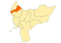 Location within West Kalimantan | |
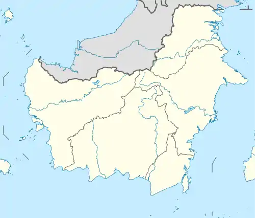 Bengkayang Regency Location in Kalimantan and Indonesia  Bengkayang Regency Bengkayang Regency (Indonesia) | |
| Coordinates: 1.0691°N 109.6639°E | |
| Country | Indonesia |
| Province | West Kalimantan |
| Capital | Bengkayang |
| Government | |
| • Regent | Suryadman Gidot |
| • Vice Regent | Agustinus Naon |
| Area | |
| • Total | 5,396.30 km2 (2,083.52 sq mi) |
| Population (2019)[1] | |
| • Total | 255,261 |
| • Density | 47/km2 (120/sq mi) |
| Time zone | UTC+7 (IWST) |
| Area code | (+62) 562 |
| Website | bengkayangkab |
Bengkayang is in northern West Kalimantan, sharing a border with Sarawak in Malaysia. With arable land and favourable relief, the agricultural sector is the main economic source.[4] Bengkayang is also rich in natural resources.
Bengkayang is still lagging in term of economic development, but there is a hope that providing local autonomy will catalyze development. A water processing plant has been developed, so the population can enjoy access to clean water.
Administrative districts
The regency is divided into seventeen districts (kecamatan), tabulated below with their areas and their populations at the 2010 Census,[5] together with the latest official estimates (for mid 2017).[6] The table also includes the number of administrative villages (rural desa and urban keluraham) in each district and its post code.
| Name | Area in km2 | Pop'n Census 2010 | Pop'n Estimate mid 2017 | No. of vill. | Post code |
|---|---|---|---|---|---|
| Sungai Raya (Raya River) | 75.85 | 18,333 | 18,983 | 5 | 79272 |
| Capkala | 46.35 | 7,579 | 8,564 | 6 | 79271 |
| Sungai Raya Kepulauan (Raya River Islands)(a) | 394.00 | 20,922 | 22,540 | 5 | 79273 |
| Samalantan | 420.50 | 18,240 | 22,177 | 7 | 79280 |
| Monterado | 290.00 | 24,453 | 26,915 | 11 | 79181 |
| Lembah Bawang (Onion Valley) | 188.00 | 5,191 | 6,308 | 8 | 79281 |
| Bengkayang | 167.04 | 23,764 | 32,141 | 6 | 79212 & 79213 |
| Teriak | 231.51 | 12,464 | 14,277 | 18 | 79214 |
| Sungai Betung (Betung River) | 205.95 | 8,919 | 9,990 | 4 | 79211 |
| Ledo | 481.75 | 11,076 | 10,494 | 12 | 79283 |
| Suti Semarang | 280.84 | 4,579 | 5,028 | 8 | 79288 |
| Lumar | 275.21 | 5,764 | 6,430 | 5 | 79282 |
| Sanggau Ledo | 392.50 | 11,198 | 12,470 | 5 | 79284 |
| Tujuh Belas | 221.00 | 11,216 | 12,271 | 4 | 79250 |
| Seluas | 506.50 | 17,051 | 21,881 | 6 | 79285 |
| Jagoi Babang | 655.00 | 8,277 | 10,275 | 6 | 79286 |
| Siding | 563.30 | 6,251 | 6,340 | 8 | 79287 |
| Totals | 5,396.30 | 215,277 | 247,084 | 124 |
Note: (a) includes coastal part of mainland Kalimantan as well as 12 offshore islands.
Climate
Bengkayang has a tropical rainforest climate (Af) with heavy rainfall year-round.
| Climate data for Bengkayang | |||||||||||||
|---|---|---|---|---|---|---|---|---|---|---|---|---|---|
| Month | Jan | Feb | Mar | Apr | May | Jun | Jul | Aug | Sep | Oct | Nov | Dec | Year |
| Average high °C (°F) | 29.4 (84.9) |
29.7 (85.5) |
30.4 (86.7) |
30.8 (87.4) |
31.3 (88.3) |
31.0 (87.8) |
30.8 (87.4) |
30.8 (87.4) |
30.7 (87.3) |
30.7 (87.3) |
30.3 (86.5) |
29.9 (85.8) |
30.5 (86.9) |
| Daily mean °C (°F) | 25.7 (78.3) |
25.9 (78.6) |
26.2 (79.2) |
26.5 (79.7) |
26.8 (80.2) |
26.6 (79.9) |
26.3 (79.3) |
26.4 (79.5) |
26.4 (79.5) |
26.5 (79.7) |
26.3 (79.3) |
26.0 (78.8) |
26.3 (79.3) |
| Average low °C (°F) | 22.0 (71.6) |
22.2 (72.0) |
22.1 (71.8) |
22.3 (72.1) |
22.4 (72.3) |
22.2 (72.0) |
21.9 (71.4) |
22.0 (71.6) |
22.2 (72.0) |
22.4 (72.3) |
22.3 (72.1) |
22.2 (72.0) |
22.2 (71.9) |
| Average rainfall mm (inches) | 307 (12.1) |
237 (9.3) |
243 (9.6) |
268 (10.6) |
240 (9.4) |
172 (6.8) |
142 (5.6) |
190 (7.5) |
211 (8.3) |
307 (12.1) |
331 (13.0) |
325 (12.8) |
2,973 (117.1) |
| Source: Climate-Data.org[7] | |||||||||||||
References
- Badan Pusat Statistik, Jakarta, 2020.
- "Archived copy". Archived from the original on 2011-08-19. Retrieved 2011-06-11.CS1 maint: archived copy as title (link)
- Badan Pusat Statistik, Jakarta, 2020.
- "Archived copy". Archived from the original on 2011-08-19. Retrieved 2011-06-08.CS1 maint: archived copy as title (link)
- Biro Pusat Statistik, Jakarta, 2011.
- Badan Pusat Statistik, Jakarta, 2020.
- "Climate: Bengkayang". Climate-Data.org. Retrieved 24 November 2020.
Regencies and cities of West Kalimantan | ||
|---|---|---|
Capital: Pontianak | ||
| Regencies | ||
| Cities | ||