Marylebone
Marylebone (/ˈmærɪləbən/ or /ˈmærələbən/, /ˈmærɪbən/, /ˈmɑːrlɪbən/)[1] is a district in the West End of London, in the City of Westminster. Oxford Street, Europe's busiest shopping street, forms its southern boundary.

An ancient parish and latterly a metropolitan borough, it merged with the boroughs of Westminster and Paddington to form the new City of Westminster in 1965.
Marylebone station lies two miles north-west of Charing Cross.
History
Marylebone was originally an Ancient Parish which took its name from its church, dedicated to St Mary, and represented by St Marylebone Parish Church (rebuilt on a new site in 1817); the original church was built on the bank of a small stream or "bourne", called the Tybourne or Tyburn.[2] This stream rose further north in what became Swiss Cottage in Hampstead, eventually running along what became Marylebone Lane, which preserves its curve within the grid pattern. The original name of the parish was simply Marybourne, the stream of St Mary; the French "le" appeared in the 17th century, under the influence of names like Mary-le-Bow.[3] The suggestion that the name derives from Marie la Bonne, or "Mary the Good", is not substantiated.[4]
Manors and parish
The parish was formed to serve the manors (landholdings) of Lileston (in the west - which gives its name to modern Lisson Grove) and Tyburn in the east, both of which were mentioned in the Domesday Book of 1086.[5] Domesday recorded eight households in each manor,[6][7] implying a combined population of less than a hundred.
The parish is likely to have been in place since at least the twelfth century and to have had consistent boundaries since that time.[8]
At Domesday the Manor of Lilestone was valued at 60 shillings and owned by a woman called Ediva, while Tyburn a possession of the Nunnery of Barking Abbey and valued at 52 shillings. Early in the 13th century Tyburn was held by Robert de Vere, 3rd Earl of Oxford. At the end of the 15th century Thomas Hobson bought up the greater part of the manor; in 1544 his son Thomas exchanged it with Henry VIII,[9] who enclosed the northern part of the manor as a deer park, the distant origin of Regent's Park. Lilestone Manor also passed into the hands of the Crown at this time.[10]
Tyburn manor remained with the Crown until the southern part was sold in 1611 by James I, who retained the deer park, to Edward Forest,[11] who had held it as a fixed rental under Elizabeth I. Forest's manor of Marylebone then passed by marriage to the Austen family. The deer park, Marylebone Park Fields, was let out in small holdings for hay and dairy produce.[12]
Urbanisation
In 1710, John Holles, Duke of Newcastle, purchased the manor for £17,500,[13] and his daughter and heir, Lady Henrietta Cavendish Holles, by her marriage to Edward Harley, Earl of Oxford, passed it into the family of the Earl of Oxford, one of whose titles was Lord Harley of Wigmore. She and the earl, realising the need for fashionable housing north of the Oxford Road (now Oxford St), commissioned the surveyor and builder John Prince to draw a master plan that set Cavendish Square in a rational grid system of streets.
The Harley heiress Lady Margaret Cavendish Harley married William, 2nd Duke of Portland, and took the property, including Marylebone High Street, into the Bentinck family. Such place names in the neighbourhood as Cavendish Square and Portland Place reflect the Dukes of Portland landholdings and Georgian-era developments there. In 1879 the fifth Duke died without issue and the estate passed through the female line to his sister, Lucy Joan Bentinck, widow of the 6th Baron Howard de Walden.
Most of the Manor of Lileston was acquired by Sir William Portman in 1554, and much of this was developed by his descendants as the Portman Estate in the late 1700's. Both estates have aristocratic antecedents and are still run by members of the aforementioned families. The Howard de Walden Estate owns, leases and manages the majority of the 92 acres (37 ha) of real estate in Marylebone which comprises the area from Marylebone High Street in the west to Robert Adam's Portland Place in the east and from Wigmore Street in the south to Marylebone Road in the north.[14]
Social history
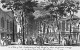
In the 18th century the area was known for the raffish entertainments in Marylebone Gardens, the scene of bear-baiting and prize fights by members of both sexes, and for the duelling grounds in Marylebone Fields.[15] The Crown repurchased the northern part of the estate in 1813.
Latter administrative history
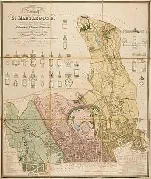
The Metropolitan Borough of St Marylebone was a metropolitan borough of the County of London between 1899 and 1965, after which, with the Metropolitan Borough of Paddington and the Metropolitan Borough of Westminster it was merged into the City of Westminster. The Metropolitan Borough inherited the boundaries of the Ancient Parish which had been fixed since at least the 12th century.
20th century
Marylebone was the scene of the Balcombe Street siege in 1975, when Provisional Irish Republican Army terrorists held two people hostage for almost a week.
Streets
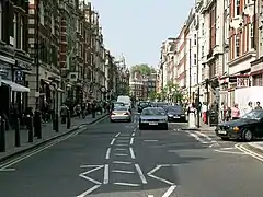
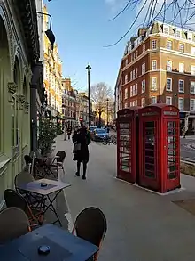
.jpg.webp)
Marylebone is characterised by major streets on a grid pattern such as Gloucester Place, Baker Street, Marylebone High Street, Wimpole Street, Harley Street and Portland Place, with smaller mews between the major streets.
Mansfield Street is a short continuation of Chandos Street built by the Adam brothers in 1770, on a plot of ground which had been underwater. Most of its houses are fine buildings with exquisite interiors, which if put on the market now would have an expected price in excess of £10 million. It has attracted people who understand attractive buildings – at Number 13 lived religious architect John Loughborough Pearson who died in 1897, and designer of Castle Drogo and New Delhi Sir Edwin Lutyens, who died in 1944.[16] Immediately across the road at 61 New Cavendish Street lived Natural History Museum creator Alfred Waterhouse.[17]
Queen Anne Street is an elegant cross-street which unites the northern end of Chandos Street with Welbeck Street. The painter JMW Turner moved to 47 Queen Anne Street in 1812 from 64 Harley Street, now divided into numbers 22 and 23, and owned the house until his death in 1851. It was known as "Turner's Den", becoming damp, dilapidated,[18] dusty, dirty, with dozens of Turner's works of art now in the National Gallery scattered throughout the house, walls covered in tack holes and a drawing room inhabited by cats with no tails.
During the same period a few hundred yards to the east, Chandos House in Chandos Street was used as the Austro-Hungarian Embassy and residence of the fabulously extravagant Ambassador Prince Paul Anton III Esterhazy,[19] seeing entertainment on a most lavish scale. The building is one of the finest surviving Adam houses in London, and now lets rooms.
Marylebone is also home to the historical Nottingham Place. It is characterized by its ornate red buildings, leading up to Marylebone Road. Most recently, in 2017–18, Number 28 was home to notable Indian artists, musicians, diplomats and all-round Renaissance men. Their tenure was prematurely cut short.
Wimpole Street runs from Henrietta Place north to Devonshire Street, becoming Upper Wimpole en route – the latter where Arthur Conan Doyle opened his ophthalmic practice at number 2 in 1891. A six-floor Grade II 18th-century house at 57 Wimpole Street is where Paul McCartney resided from 1964 to 1966, staying on the top floor of girlfriend Jane Asher's family home in a room overlooking Browning Mews in the back, and with John Lennon writing "I Want to Hold Your Hand" on a piano in the basement. At her father's house at number 50 lived for some time between 1840 and 1845, Elizabeth Barrett, then known as the author of a volume of poems, and who afterwards escaped and was better known as Elizabeth Barrett Browning. Today, at the bottom end of Wimpole at Wigmore can be found a sandwich shop named "Barrett's".
Bentinck Street leaves Welbeck Street and touches the middle of winding Marylebone Lane. Charles Dickens lived at number 18 with his indebted father (on whom the character Wilkins Micawber was based) while working as a court reporter in the 1830s, and Edward Gibbon wrote much of The Decline and Fall of the Roman Empire while living at number 7 from the early 1770s. James Smithson wrote the will that led to the foundation of the Smithsonian Institution while living at number 9 in 1826, while number 10 was briefly graced by Chopin in 1848, who found his apartment too expensive and moved to Mayfair. More recently, Cambridge spies Anthony Blunt and Guy Burgess lived at 5 Bentinck Street during the Second World War.[20] In 1960s two-some John Dunbar and TV repairman "Magic Alex" lived on the street, where the former introduced the latter to John Lennon in 1967. Princess Alexandra, 2nd Duchess of Fife, who was a qualified nurse, founded a nursing home in Bentinck Street, and served as its matron.[21]
Manchester Square, west of Bentinck Street, has a central private garden with handsome plane trees, laid out in 1776. The mansion on the north side of the square, now the home of the Wallace Collection that features world-class French eighteenth-century painting, porcelains and furniture, once housed the Spanish ambassador, whose chapel was in Spanish Place. From the north-west corner is Manchester Street, final home of Georgian-era prophet Joanna Southcott, who died there in 1814, having attracted a jeering mob with report of a miraculous birth and prediction the Day of Judgement would arrive in the year 2004.
Marylebone has some "Beatles" heritage, with a John Lennon flat at 34 Montagu Square, and the original Apple Corps headquarters at 95 Wigmore Street.
Bulstrode Street, small and charming, is named after a Portman family estate in Buckinghamshire, itself named after a local family there made-good in Tudor days. Tucked away, with a few terraced houses, Bulstrode Street has been the home of minor health care professionals for hundreds of years. The RADA student and aspiring actress Vivien Leigh, aged twenty in 1933, gave birth at the Rahere Nursing Home, then at number 8, to her first child.
The north end of Welbeck Street joins New Cavendish Street, the name of which changed from Upper Marylebone Street after World War I. Number 13 in New Cavendish Street, at its junction with Welbeck Street and on the corner of Marylebone Street, was the birthplace in 1882 of the orchestral conductor Leopold Stokowski, the son of a Polish cabinet maker. He sang as a boy in the choir of St Marylebone Church.
At the northern end of Marylebone High Street towards the Marylebone Road there is an area with a colourful history, which includes the former Marylebone Gardens, whose entertainments including bare-knuckle fighting, a cemetery, a workhouse, and the areas frequented by Charles Wesley, all shut down by the close of the 18th century, where today there are mansion blocks and upper-end retail.
At No. 1 Dorset Street resided mid-Victorian scientist Charles Babbage, inventor of the analytical engine. Babbage complained that two adjacent hackney-coach stands in Paddington Street ruined the neighbourhood, leading to the establishment of coffee and beer shops, and furthermore, the character of the new population could be inferred from the taste they exhibited for the noisiest and most discordant music.[22] An acclaimed international venue for chamber music, the Wigmore Hall, opened at 36 Wigmore Street in 1901. It hosts over 500 concerts each year.[23]
The Marylebone Low Emission Neighbourhood was established in 2016 to improve the air quality of the area.[24][25] Westminster City Council in partnership with local residents, businesses and stakeholders completed a green grid of 800 new trees on Marylebone's streets in 2019.[26][27][28]
Representation
The area was represented by the St Marylebone UK Parliament constituency between 1918 and 1983.
The area is currently divided between the Cities of London and Westminster and Westminster North parliamentary constituencies. These are represented by Nickie Aiken and Karen Buck respectively.
Geography
The Parish and Borough was bounded by two Roman Roads, Oxford Street to the south and Watling Street (Edgeware Road) to the west, and positioned on both side of the former River Tyburn which flowed from north to south. To the north (Boundary Road in St John's Wood) and east (running through Regent's Park and along Cleveland Street), the area's boundaries have been inherited as part of the north and eastern boundary of the modern City of Westminster.
This area includes localities such as St John's Wood, Lisson Grove and East Marylebone.[29] East Marylebone has since the 1940's been viewed as a part of Fitzrovia.
Places of interest include Marylebone Village, most of Regent's Park, Marylebone Station, the original site of the Marylebone Cricket Club at Dorset Square.
Neighbouring areas of London | |
|---|---|
Areas and features of Marylebone include:
- All Souls Church, Langham Place (designed by John Nash)
- Baker Street (including the fictitious 221B Baker Street)
- Broadcasting House (BBC headquarters)
- Bryanston Square
- Dorset Square
- Duke Street, Marylebone
- Harley Street
- Hinde Street Methodist Chapel
- Holy Trinity Church, Marylebone (designed by Sir John Soane)
- Hyde Park
- Langham Hotel, London (built in the 1860s)
- London Business School, founded in 1964
- Madame Tussaud's
- Manchester Square (Georgian square)
- Marble Arch
- Marylebone High Street
- Montagu Square (Regency square)
- Regent's Park (which houses London Zoo)
- Royal Academy of Music
- Royal Institute of British Architects
- Selfridges Department Store
- St. James's, Spanish Place
- St Peter, Vere Street (designed in 1722 by James Gibbs)
- University of Westminster
- Wallace Collection
- West London Mission at 19 Thayer Street
- Wigmore Hall
- Wigmore Street
- Wyndham Place
Landmarks
Former landmarks
- Egton House, studio of BBC Radio 1, demolished
- Queen's Hall, classical music concert venue destroyed by fire in World War II
- Marylebone Gardens a former pleasure ground and venue for concerts, closed in 1778
- St. George's Hall, a theatre built in 1867, demolished 1966.
- Yorkshire Stingo, a public house on Marylebone Road.
- St Marylebone Grammar School on the corner of Lisson Grove and Marylebone Road, now offices.
- Theatre Royal, Marylebone, a former music hall opened in 1832 at 71 Church Street, demolished in 1959.[30]
Transport
Tube stations
Railway stations
Education
- Halcyon London International School (International school on Seymour Place)
- St Marylebone School (comprehensive specialist school in Performing Arts, Maths & Computing for girls founded in 1791)
- Sylvia Young Theatre School (fee paying performing arts school)
- St Vincent's RC Primary School (Catholic Voluntary Aided Mixed School)
- Francis Holland School (independent day school for girls)
- Portland Place School (independent secondary school)
- The Royal Academy of Music on Marylebone Road
- The University of Westminster on Marylebone Road and upper Regent Street
- Regent's College, whose campus is within the grounds of Regent's Park, which houses:European Business School London; British American College London; Regent's Business School; School of Psychotherapy and Counselling; Webster Graduate School; Internexus, a provider of English language courses.
- L'Ecole Internationale Franco-Anglaise (international school providing English-French bilingual education)
- Queen’s College Preparatory School (independent day school for girls)
- Southbank International School on Portland Place
References
- Pointon, Graham, ed. (1990). BBC Pronouncing Dictionary of British Names (2nd ed.). Oxford: The University Press. ISBN 0-19-282745-6.
- "Maryburne rill", in Harrison's Description of England 1586, noted by Henry Benjamin Wheatley and Peter Cunningham, London Past and Present: its history, associations, and traditions, Volume 2, p. 509.
- Mills, David (2010). A Dictionary of London Place-Names (2nd ed.). Oxford: The University Press. ISBN 978-0-199-56678-5.
- Zachrisson, Robert Eugen (1917). "Marylebone–Tyburn–Holborn". Modern Language Review. 12 (2).
- London Encyclopaedia, Weinreb and Hibbert, 1983
- Domesday entry for Lisson https://opendomesday.org/place/TQ2782/lisson/
- Domesday entry for Tyburn https://opendomesday.org/place/TQ2780/marylebone/
- Churches in the Landscape, Richard Morris, JM Dent and Sons 1989. Chapter 4 describes how the parish system was completed (bar a few exceptions) in the 12th century and new Canon Law made changes to boundaries very difficult and rare.
- Wheatley and Cunningham, p. 509.
- London Encyclopaedia - entry for Mbone states that both Mnaors came into the hands of the Crown at the time of the dissolution of the monasteries.
- 'The Regent's Park', Old and New London 5 (1878:262–286) Archived 17 September 2013 at the Wayback Machine. Retrieved 3 July 2010.
- B. Weinreb and C. Hibbert, eds (1995), The London Encyclopedia, Macmillan ISBN 0-333-57688-8
- Wheatley and Cunningham; they note the annual rents brought in £900.
- The Howard de Walden Estate Archived 22 March 2009 at the Wayback Machine
- Wheatley and Cunningham, p. 511.
- "LUTYENS, Sir Edwin Landseer (1869-1944) & PEARSON, John Loughborough (1817-1897) English Heritage". www.english-heritage.org.uk. Archived from the original on 10 April 2016. Retrieved 27 March 2016.
- "WATERHOUSE, Alfred (1830-1905) English Heritage". www.english-heritage.org.uk. Archived from the original on 10 April 2016. Retrieved 27 March 2016.
- Gayford, Martin. "JMW Turner: the man behind the masterpieces". The Daily Telegraph. Archived from the original on 21 October 2017. Retrieved 5 April 2018.
- "Austrian Foreign Ministry -> Embassy -> London -> History of the Austrian Embassy". www.bmeia.gv.at. Archived from the original on 15 December 2012. Retrieved 27 March 2016.
- Lownie, Andrew (2015). Stalin's Englishman: The Lives of Guy Burgess. London: Hodder and Stoughton. pp. 114–115.
- Princess Arthur of Connaught dated 29 November 2010 at royalmusingsblogspotcom
- Babbage's pamphlet Street Nuisances (1864) http://www.hrc.wmin.ac.uk/theory-babbagesdancer2.html Archived 24 December 2014 at the Wayback Machine Retrieved 4 August 2017
- Tester, Maestro Jonathon. "2017/18 Season Preview | News | About Us". Wigmore Hall. Retrieved 7 June 2019.
- WCC. "Poor air quality is a major concern for people who visit, live and work in the area". Marylebone Low Emission Neighbourhood. Retrieved 7 June 2019.
- Hill, Dave (15 February 2017). "'Filthy glamour': could polluted Marylebone Road help fix London's air?". The Guardian. ISSN 0261-3077. Retrieved 7 June 2019.
- "The W1W Tree Planting Initiative for Marylebone". The W1W Tree Planting Initiative for Marylebone. Retrieved 7 June 2019.
- w1wtrees (15 December 2009). "W1W Tree Planting in Marylebone — Media Files". The W1W Tree Planting Initiative for Marylebone. Retrieved 7 June 2019.
- Bloom, Ben. "Veteran BBC reporter plants 500th tree of Marylebone ecology project". Hampstead Highgate Express. Retrieved 7 June 2019.
- "History of St Marylebone, in Westminster and Middlesex – Map and description". visionofbritain.org.uk. Archived from the original on 17 September 2013. Retrieved 15 October 2013.
- "Westminster Green Plaques Scheme – review of criteria and funding" (PDF). City of Westminster. 12 January 2012. Archived from the original (PDF) on 3 July 2015. Retrieved 7 July 2015.
Theatre Royal Marylebone 71 Church Street, NW8; 1832–1959
External links
| Wikimedia Commons has media related to Marylebone. |
| Wikisource has the text of the 1905 New International Encyclopedia article "Marylebone". |
 London/Mayfair-Marylebone travel guide from Wikivoyage
- Marylebone Village
- Hampstead and Marylebone by G. E. Mitton at Project Gutenberg
- Chisholm, Hugh, ed. (1911). . Encyclopædia Britannica. 24 (11th ed.). Cambridge University Press. p. 30.
- The Marylebone Association. The amenities society for Marylebone representing its residents, businesses and people who live and/or work in Marylebone. The Association's area is bounded by Oxford Street (South), Edgware Road (West), Marylebone Road (North) and Great Portland Street (East).
- The St Marylebone Society An amenities society that represents residents North of the Marylebone Road
- The Marylebone Forum is the designated neighbourhood planning forum for the area of Marylebone.
| Authority control |
|---|