Wembley
Wembley (/ˈwɛmbli/) is the principal town of the borough of Brent in north west London, England, about 8 miles (13 km) west-northwest of Charing Cross. Wembley was formed a separate civil parish from 1894 and was incorporated as a municipal borough of Middlesex in 1937. In 1965, the area merged with the Municipal Borough of Willesden, which was separated by the River Brent, to create the London Borough of Brent, and has since formed part of Greater London.
| Wembley | |
|---|---|
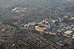 An aerial view of Wembley, showing part of High Road, the industrial estate, SSE Arena and Wembley Stadium | |
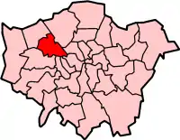
 Wembley Location within Greater London | |
| Population | 0 (2011 Census[1] |
| OS grid reference | TQ175855 |
| London borough | |
| Ceremonial county | Greater London |
| Region | |
| Country | England |
| Sovereign state | United Kingdom |
| Post town | Wembley |
| Postcode district | HA0, HA9 |
| Dialling code | 020 |
| Police | Metropolitan |
| Fire | London |
| Ambulance | London |
| UK Parliament | |
| London Assembly | |
The centre of Wembley was originally at the small village of "Wembly Green" accompanied by the Barley Mow public house in the 18th century. This survives today as The Green Man inn located on the steep Wembley Hill Road. The railways of the London and Birmingham Railway reached Wembley in the mid-19th century, the station originally called Sudbury and located to the south-west from the village - today it is known as Wembley Central in the heart of town - by the 1920s this part now known as High Road had become an important shopping centre and increasingly a suburb of London.[2][3]
The estate of Wembley Park was used as pleasure grounds as the Metropolitan Railway reached this part in 1894. Eventually the area was chosen to host the British Empire Exhibition in 1924, resulting in the development of landmarks including the Empire Stadium, later known as Wembley Stadium, which in later years became an iconic football stadium.[4] Suburban development of the surrounding areas following the Exhibition has ensured that Wembley remains an integral part of Metroland in the popular imagination. After years of debate, the old stadium was demolished and replaced by a modernised stadium with a distinctive arch which opened in 2007;[4] it is home to the England national football team and is the largest stadium by capacity in the UK.
The town of Wembley also includes the localities of Alperton, North Wembley, Tokyngton, Wembley Park, Sudbury, and Preston. The total population of the seven wards that make it up was 102,856 as of 2011.[5]
History
| ◄ Split from Harrow on the Hill | |
| 1901 | 4,519 |
|---|---|
| 1911 | 10,696 |
| 1921 | 16,187 |
| 1931 | 48,561 |
| ◄ Kingsbury parish absorbed | |
| 1941 | war # |
| 1951 | 131,384 |
| 1961 | 124,892 |
| # no census was held due to war | |
| source: UK census | |
Toponomy
Wembley is derived from the Old English proper name "Wemba" and the Old English "lea" for meadow or clearing. The name was first mentioned in the charter of 825 of Selvin. A further instance may be seen in the Plea Rolls of the Common Pleas, as Wambeleye.[6]
The old manor
The village of Wembley grew up on the hill by the clearing with the Harrow Road south of it. Much of the surrounding area remained wooded. In 1547 there were but six houses in Wembley. Though small, it was one of the wealthiest parts of Harrow. At the dissolution of the monasteries in 1543, the manor of Wembley fell to Richard Andrews and Leonard Chamberlain, who sold it to Richard Page, Esq., of Harrow on the Hill, the same year. There was a mill on Wembley Hill by 1673.
The Page family continued as lords of the manor of Wembley for several centuries and eventually commissioned Humphry Repton (1752–1818) the landscape gardener to design what is now Wembley Park.[7][8] Wembley Park thus derived its name from Repton's habit of referring to the areas he designed as "parks".
Railways and development
In 1837, the London and Birmingham Railway (now part of the West Coast Main Line) was opened from London Euston through Wembley to Hemel Hempstead, and completed to Birmingham Curzon Street the following year. The changing names of the local station demonstrated the increasing importance of the 'Wembley' name. 'Sudbury' station opened in 1845, renamed as 'Sudbury and Wembley' in 1882, renamed as 'Wembley for Sudbury' in 1910, renamed as 'Wembley Central' in 1948, at the time of the Olympic Games.
To modernise the service, a new Watford DC Line was built alongside the main lines and Bakerloo line trains, and electric trains to Broad Street started in 1917. Electric trains to London Euston began running in 1922. Since 1917, there have been six platforms at what is now Wembley Central station. In 1880, the Metropolitan Railway opened its line from Baker Street through the eastern side of Wembley, but only built a station, Wembley Park, in 1894. There are now three physically separate services, the London to Aylesbury Line, the Metropolitan line, and the Jubilee line. Only the latter two services have platforms at Wembley Park station.
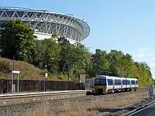
In November 1905, the Great Central Railway (now, in this section, part of the Chiltern Main Line) opened a new route for fast expresses that by-passed the congested Metropolitan Railway tracks. It ran between Neasden Junction, south of Wembley, and Northolt Junction, west of London, where a new joint main line with the Great Western Railway began. Local passenger services from London Marylebone were added from March 1906, when new stations were opened, including 'Wembley Hill', next to what later became the site of Wembley Stadium – the national stadium of English sport – which opened for the FA Cup Final of April 1923, remaining open for 77 years until it closed for reconstruction in October 2000.[9] After a long planning and redevelopment process dogged by a series of funding problems and construction delays, the new stadium finally opened its doors in March 2007.[10] Wembley Hill station was renamed 'Wembley Complex' in May 1978, before getting its present name of 'Wembley Stadium' in May 1987.[11]
Wembley was also served by tram (route 62) and later trolleybus (route 662) which ran through the Harrow Road from Sudbury to Paddington until the abandonment of the networks.[12] The route is now mostly served by bus route 18 which is also one of the busiest bus routes in all of London today.[13]
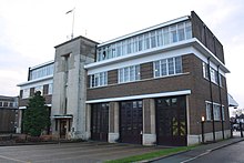
The fire brigade headquarters of Middlesex County Council were located on Harrow Road and is now a fire station of the London Fire Brigade.
Wembley, in common with much of northwest London, had an extensive manufacturing industry, but much of it closed in the 1980s. Factories in the area included Glacier Metals (bearings), Wolf Power Tools, Sunbeam Electrical Appliances, Griffin & George (laboratory equipment) and GEC (whose research laboratories, opened in 1923, were one of the first of their type in the United Kingdom[14]).
Empire Exhibition and the Stadium
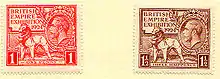
The area around the current Wembley Stadium was the location of the British Empire Exhibition[15][16][17] of 1924–1925.[18][19][20][21] Until the 2000s, remnants of the many reinforced concrete buildings, including the original Wembley Stadium, remained, but nearly all have now been removed, to make way for redevelopment.
Most of the rest of Wembley's housing consists of inter-war semi-detached houses and terraces and of modern apartment blocks, with a significant minority of detached housing.
Expansion in the town centre continued. In 1929 the Majestic Theatre was opened, later becoming Odeon Wembley cinema. It closed in 1961 and was demolished, replaced by a C&A store (today a Wilko store).[22] Another cinema in the town was an ABC cinema originally opened as The Regal in 1937, located on Ealing Road, which operated until 1976. After this it operated for some years as an independent cinema showcasing Bollywood films. The building was demolished in 1987.[23]
Post-war
During the 1960s, rebuilding of Wembley Central station, a block of flats, an open-plan shopping plaza, and a car park were constructed on a concrete raft over the railway. The retail centre of Wembley (the High Road and north end of Ealing Road) has suffered from chronic traffic congestion and from the opening of neighbouring purpose-built shopping centres, first Brent Cross Shopping Centre in the 1970s and later the Harrow and Ealing Broadway shopping centres.
Following continuing decline, Wembley had become unattractive and increasingly derelict by the century end. However the large Indian community in the town maintained a growing jewellery market with their shops on Ealing Road.[3]
There also used to be a British Army recruitment centre off the High Road in Wembley. This centre came under attack by an IRA bomb in 1990 resulting in the death of a soldier and injuries to four people (see 1990 Wembley bombing).[24]
Recent regenerations
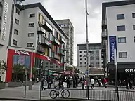
The town's regeneration is one of the major development projects in London in the early 21st century, as specified in the London Plan published by the Mayor of London Ken Livingstone in 2004. The shopping plaza at High Road, which was an attractive shopping district in the 1950s, suffered slow decline by the 1980s and was therefore poorly maintained.[3] The Marks & Spencer department store on High Road closed in 2005 after 71 years trading.[25]
In a bid to reverse Wembley's fortunes, in the mid-2000s plans were created and approved to completely regenerate the place, carried out by construction company St. Modwen. The first phase, including construction of eighty-five homes, reconstruction of the plaza as a new public square and opening of new retail units including a TK Maxx, was completed in 2009.[26][27] The rest was completed in phases until 2015 after nine years' time, with additional retail and housing units.[28] The local Argos store also moved to a new unit in the redeveloped Central Square.
Purpose-built Brent Civic Centre near the stadium was completed in 2013, with all Brent administration moving to this complex. As a result, other offices were closed. The Chesterfield House block on Park Lane that was used as council offices, built in the 1960s replacing a Methodist church that moved further down the road, was demolished in 2017 and replaced by 21 and 26 storey blocks of apartments.[29][30] Brent House, an office complex on High Road, was sold by the council sold Brent House to a developer called Henley Homes who demolished the building and also replaced it with residential apartments.[31] Mahatma Gandhi House on Wembley Hill Road, another council office block, was also sold off.[32] The listed Brent Town Hall was also disposed and became a French school, Lycée International de Londres Winston Churchill.
The regeneration project is focused on the "Wembley Park" site which includes Wembley Stadium and Wembley Arena, about a mile northeast from Wembley town centre. The Original Wembley Stadium closed in October 2000 and was demolished in 2003.[33] The new Wembley stadium was designed by a consortium including engineering consultant Mott MacDonald and built by the Australian firm Multiplex. It cost £798 million and opened in 2007.[34] Grade II-listed Wembley Arena, now the SSE Arena, has been sensitively refurbished in keeping with its Art Deco style.[35] In 2004, Brent Council approved a mixed use plan by Buro Happold for the development of 55 acres (223,000 m2) adjacent to the stadium, which was presented by Quintain Limited.
Governance
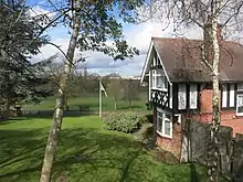
%252C_Wembley_-_geograph.org.uk_-_865102.jpg.webp)
Wembley falls within the UK Parliament constituency of Brent North, currently represented by Barry Gardiner MP (Labour). It falls within the London Assembly constituency of Brent and Harrow.
Wembley formed part of the large ancient parish of Harrow on the Hill in the Gore hundred of Middlesex. In 1894 Wembley was split from Harrow, creating a new parish and urban district. It included Alperton, Preston, North Wembley, South Kenton, Tokyngton, Sudbury, Wembley Park and Northwick Park. The urban district included the neighbouring parish of Kingsbury until 1901 and again from 1934.
In 1937 it was incorporated as the Municipal Borough of Wembley. Wembley Town Hall on Forty Lane, built in 1938, became Brent Town Hall when the municipal boroughs of Wembley and Willesden were amalgamated in 1965 to form the London Borough of Brent and transferred to Greater London.
Willesden merger and split proposal
Brent proved to be one of the more unpopular of the mergers occurring during the creation of the modern London boroughs. Reasons for this included the limited road links between the two main areas of Wembley and Willesden (with the A4088 and A404 Harrow Road, the only major road links across the Brent valley boundary), the lack of a focal point or ‘heart’ for the borough and the contrasting characteristics; with Willesden more inner-city in nature, and Wembley more suburban. Widening schemes for the North Circular Road, which passed along the Brent valley, close to the boundary between the two, increased this sense of separation. The clash quickly turned political amid the plans to build Chalkhill Estate, as Wembley was Conservative while Willesden was Labour; the virtual balance of power between the two parties in Brent contributed to the borough becoming a byword for extremism.[3]
The unpopularity persisted and in 1989 more than ten thousand people signed a petition calling for Wembley to regain its independence or else join with the London Borough of Harrow with which it had historic administrative links, had better transport integration and had shared common suburban interests. The 1994, the Boundary Commission considered this, and other requests, considering a wide range of options[36] including restoring independence to the districts, or joining them to different neighbouring boroughs – an option the Commission preferred.
Wembley and Harrow were felt to be a natural match, and the London Borough of Harrow supported these proposals and called for a boundary rationalisation with Barnet so that the A5 Road (Watling Street) formed the enlarged borough's entire eastern boundary. Willesden was harder to satisfactorily match with a neighbour, with Ealing considered the most natural choice, the main problem being the lack of a focal point, with the industrial areas of Park Royal, Old Oak Common and North Acton forming a relatively ill-connected barrier between the two. The Commission concluded that there was insufficient justification for the disruption caused by the changes, and that such changes should only be considered during a comprehensive review of London's boundaries.
Geography
Until the nineteenth century, Wembley was rural and the sector retains a number of green spaces. These include Barham Park (10.5 hectares), King Edward VII Park, established in 1914 behind the High Road (10.5 hectares), and Sudbury Green. Less managed spaces include Fryent Country Park, Barn Hill (19.87 hectares), and Vale Farm sports ground (30 hectares). Brent River Park / Tokyngton Recreation Ground (20.26 hectares) has recently been restored, returning the river to a more natural course.
Nearby Sudbury Golf Course backs onto the Grand Union Canal, with its towpath running into central London. Sudbury Squash and Tennis Club has outdoor tennis courts, an indoor squash court, and a clubhouse. Wembley is a short distance away from the Welsh Harp reservoir and open space, created in the early 19th century by damming the River Brent to provide water for the Grand Union Canal.
Wembley is made up of six wards: Wembley Central, Alperton, Tokyngton, Barnhill, Preston and Sudbury. The town takes up the south-western quarter of the borough of Brent, being west of Harlesden and Willesden and south of Kenton.[37] It is also east of Greenford and Northolt in the neighbouring London Borough of Ealing. The area is identified in the Mayor of London's London Plan as one of thirty-five major centres in Greater London.[38] Wembley is part of both HA0 and HA9 post codes, and has its own post town.
Neighbouring areas of Wembley | |
|---|---|
Demographics

Wembley is known for its high degree of ethnic and religious diversity, and the population includes a large number of people of Asian, Afro-Caribbean and Eastern European origin.[39][40] According to the 1991 census, 49.2% of the Wembley Cental ward identified themselves as Asian (39% Indian). The ward along with neighbouring Tokyngton (eastern Wembley) and Alperton were in the top 10 most diverse in London. In the 2001 census, 78.6% of the ward identified themselves as being of black or minority ethnic (BME) groups.[41][42] The White British population of Wembley Central (792 people, 5.3% of the population) in the 2011 census makes it the sixth least White British ward in London (seventh in the country).[43] Other ethnicities include 7.0% Other White, 66.2% Asian (46.2% Indian), and 13.9% Black.[43] In 2011, 86% of Wembley Central ward was of BAME background, which is the highest in Brent and 5th highest in Greater London. In Wembley the lowest BAME ward was Northwick Park, 68.8%.[44]
The 2011 census also showed that, in the Wembley Central ward, the unemployment rate stood at 5.3%. Of the 4,380 households, 2,065 of the properties were tenure owned, 1,469 was privately rented and 684 was socially rented from the council. The largest religion was Hinduism (45%) followed by Christianity (25%). The median age was 32. By far the most spoken foreign language was Gujarati.[45] Wembley Central only covers Wembley town centre and the whole district is represented by five other wards.
There are varying levels of social deprivation in the area. Places such as the central area and Chalkhill have had relatively high deprivation, with the latter having been troubled for a long time. In more recent years, regeneration has helped helped these areas fare better albeit with a higher general cost of living. Some parts of the town meanwhile are among the least deprived in the borough, especially Barn Hill estate and North Wembley's Sudbury Court Estate.[46][47]
Economy
The main shopping area was generally centred on Wembley High Road, Central Square, and Ealing Road. Unlike typical British high streets Wembley does not have a town centre network or pedestrianised high streets, with almost all commercial high street businesses located along a 1000-yard stretch of road (High Road). In 1971 the High Road was seen as being the 11th best place to shop in London. However, it had fallen to 24th place by 1987.[48] Ealing Road remains important as a centre of South Asian jewellery and gold shops,[49] attracting people from as far afield as Leicester, but otherwise the focus of shopping has shifted north and east to the more recent development of London Designer Outlet[50] in Wembley Park, which is part of the Stadium's complex and also includes a fully pedestrianised street near the Stadium. The regenerations were done by Brent Council in an attempt to turn Wembley into a more attractive shopping destination.[51]
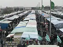
The Wembley Sunday Market was a popular market held weekly from the 1970s until 2014 and run by Wendy Fair Markets. The market was ousted by the landowners, Quintain, in favour of the London Designer Outlet development. The market was then set up at the former Unisys tower near Stonebridge Park station before it was closed within a year by the council citing traffic disruption.[52][53]
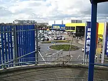
IKEA Wembley is located in the Brent Park retail area near North Circular Road, Neasden. It opened in 1988 and was the Swedish retailer's second store in the UK after the initial store in Warrington.[54]
The Air France-KLM European Sales and Service Centre, which is a sales channel for 15 European countries, is located in Brent Civic Centre in Wembley Park.[55]
Sport and leisure
Wembley has two local non-League football clubs, Wembley F.C. and South Kilburn F.C., that both play at Vale Farm stadium in nearby Sudbury. Nearby is Vale Farm Sports Centre.
There once were two golf clubs in Wembley. Wembley Golf Club, founded in 1896, was situated north of the Metropolitan Railway line in what is now the Fryent Country Park. The club closed in the late 1920s.[56] Wembley Park Golf Club was founded in 1912 in Sir Edward Watkin's Wembley Park pleasure gardens, improving on the 9-hole course that had opened, along with Watkin's Wembley Park, in 1896. The course itself became the site of the British Empire Exhibition.[57]
Landmarks
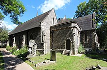
Apart from the listed 19th century St John the Evangelist church in High Road, another church of notability was the St. Andrew's Presbyterian Church in Ealing Road, built in 1904, designed by Thomas Collcutt and Stanley Hemp. Construction was of brick and the design was influenced by the Arts and Crafts Movement. It was listed as a Grade II building in 1993.[58] The church was converted into the Central Mosque Wembley in the late 1990s. To the south on Ealing Road is the large Shree Sanatan Hindu Mandir, a major mandir opened in 2010.
Roman Catholic hurch of St Joseph, a post-war church, became Grade II listed in 2016.[59]
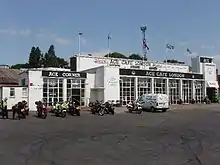
The Ace Cafe is perhaps the best known and historic transport cafe, opened in 1938 and re-opening in 1997 after decades of closure. This venue has been used to hold car and bike events by motoring enthusiasts both within and internationally.[60]
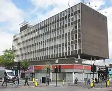
Wembley Point, formerly Station House, is a 21-storey building next to Stonebridge Park station. It was Brent's first skyscraper, built in 1965, and is visible from a radius of several miles. The building has had various uses, including partly as a gym and commercial offices, although it looks derelict to locals just as the adjacent abandoned Unisys building on the east side of the North Circular Road.[61]
Brent's only English Heritage blue plaque is on Forty Lane in Wembley, commemorating the comedian and entertainer Arthur Lucan.[62][63]
The prime landmark is Wembley Stadium, rebuilt 2003–2007 at a cost of £827 million,[64] which is approached via the White Horse Bridge designed by the London Eye architects. Nearby is the SSE Arena, a Grade II-listed concert venue built in 1934 as the Empire Pool, a multi-use facility built for the 2nd Empire Games. The former Wembley (later Brent) Town Hall is a Grade II-listed building located on Barn Hill facing Wembley Stadium; it has now been refurbished as a French school, the Lycée International de Londres Winston Churchill.[65] The London Borough of Brent's council chamber and administration have moved to the new Brent Civic Centre in Engineers Way, Wembley Park.
Transport
Tube/train
Stations in the town are:
- Wembley Stadium (Chiltern Railways)
- Wembley Central (Bakerloo line, Southern, West Midlands Trains and Watford DC Line)
- North Wembley (Bakerloo line and Watford DC Line)
- Wembley Park (Jubilee line and Metropolitan line)
- Sudbury Town (Piccadilly line)
- Preston Road (Metropolitan line)
- Alperton (Piccadilly line)
- Stonebridge Park (Bakerloo Line)
Buses
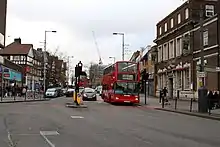
Wembley has numerous Transport for London bus routes that run through its centre on High Road, namely routes 18, 79, 83, 92, 182, 204, 223, 224, 297, 483, H17, and night route N18.
Road
Wembley lies very close to the A406 North Circular Road. The A404 Harrow Road passes through its centre. The town centre is served by three pay-and-display car parks.
SSE Arena access
Wembley Arena is served by Wembley Park station on the London Underground via Olympic Way, Wembley Stadium on the Chiltern Railways line from London Marylebone to Birmingham Snow Hill, and Wembley Central (walking via the White Horse Bridge). Bus route 92 stops directly outside.
The onsite parking facilities are close by, with a multistorey car park called Red Parking and a surface level car park on the eastern flank of the Stadium called Green Parking.[66] Disabled parking is available at a reduced rate but on a first-come first-served basis.[67]
Notable people
- Politician Luciana Berger (born 1981), The Independent Group MP, grew up in Wembley.
- Drummer Charlie Watts, founding member of The Rolling Stones, was born in Wembley.
- Engineer and Formula One aerodynamicist, John Barnard, who is credited with introducing the first semi-automatic gearbox, the first carbon fibre composite chassis and the "coke bottle" shape of the rear bodywork, was born in Wembley in 1946.
- Actor Riz Ahmed, star of satirist Chris Morris's black comedy Four Lions (2010), was born in Wembley.
- Scientist John D Barrow FRS, Professor of Mathematical Sciences at Cambridge University, cosmologist, Templeton prize winner and author of many popular science books and the award-winning play Infinities was born in Wembley in 1952 and attended Barham Primary School.
- Composer Peter Fribbins was born, and grew up, in Wembley.
- British ambassador to Israel Matthew Gould grew up in Wembley.
- Astrologer Russell Grant lived in Wembley.
- Scholar Vivian H. H. Green (1915–2005), the model for author John le Carré's spymaster character George Smiley, was born in Wembley.
- Matthew Harrison was born in Wembley in 1979.
- Actor and comedian Lenny Henry lived in Wembley.
- Actor and musician Gary Holton (1952–1985), Wayne in Auf Wiedersehen, Pet and frontman of Heavy Metal Kids, lived in Wembley at the time of his death.
- Footballers Raheem Sterling, Jerel Ifil, and Jerome Thomas lived in Wembley.
- Musician John Lingwood, drummer in Manfred Mann's Earth Band, was born in Wembley.
- The actor Arthur Lucan (Arthur Towle), famous for his performances as 'Old Mother Riley', lived at 11 Forty Lane, Wembley, as did his wife and co-star, Catherine 'Kitty' McShane.
- Actor Robert McBain (1932–2004), who appeared in Fawlty Towers and A Fish Called Wanda, was born in Wembley.
- Rock legend Keith Moon (1946–1978), drummer for The Who, lived in Wembley.
- Singer Maxine Nightingale, best known for her soul hit records in the 1970s, was born in Wembley.
- Figure-skater Valda Osborn was born in Wembley.
- Nurse, journalist, broadcaster and novelist Claire Rayner lived in Wembley.
- Dancer, author, musician and bandleader Victor Silvester was the second son of J. W. P. Silvester, vicar of St. John the Evangelist Anglican church, Wembley.
- Composer John Tavener was born in Wembley.
- Musician Harvey Shield grew up in Wembley.
- Mick Whelan, head of the ASLEF trade union, lives in Wembley.
- Sir Henry Cooper, British Heavyweight Champion, after his famous fight with Cassius Clay in Wembley's Empire Pool on 18/6/63 retired to Wembley and opened a greengrocer's shop at the top of Ealing Road in Wembley. He relocated to South Kenton in Wembley to live until his wife passed away.
Gallery
_-_geograph.org.uk_-_216336.jpg.webp) High Road, looking west towards the junction with Park Lane
High Road, looking west towards the junction with Park Lane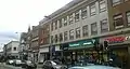 Site of the former Marks and Spencer on High Road, now divided between four units
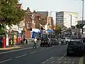 Western section of High Road, looking east
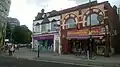 Shops near the High Road/Wembley Hill Road junction
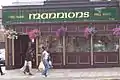 Mannions Free House, Irish pub, on High Road
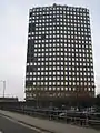 Wembley Point skyscraper, next to the North Circular Road
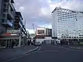 York House and London Designer Outlet
.jpg.webp) Bland's, a small department store on High Road that traded from 1911 to 2017
Bland's, a small department store on High Road that traded from 1911 to 2017
References
| Wikimedia Commons has media related to Wembley. |
- Wembley is made up of 7 wards in the London Borough of Brent: Alperton, Barnhill, Northwick Park, Preston, Sudbury, Tokyngton, and Wembley Central. "Archived copy". Archived from the original on 22 February 2014. Retrieved 9 June 2014.CS1 maint: archived copy as title (link)
- https://www.brent.gov.uk/media/387577/Wembley%20Park%20up%20to%201922.pdf
- https://www.brent.gov.uk/services-for-residents/culture-leisure-and-parks/brent-museum-and-archives/find-out-about-your-local-area/history-of-wembley-and-tokyngton/
- https://failedarchitecture.com/how-the-british-buried-their-imperial-history-along-with-wembley-football-stadium/
- "Archived copy". Archived from the original on 22 February 2014. Retrieved 9 June 2014.CS1 maint: archived copy as title (link)
- aalt.law.uh.edu; http://aalt.law.uh.edu/E3/CP40no357/aCP40no357mm1toEnd/IMG_7441.htm; third entry, line 3, "apud Wambeleye"; in 1349
- "Harrow on the Hill – British History Online".
- "Harrow, including Pinner : Manors – British History Online".
- TheFA. "404 - Page not found - wembleystadium.com". Archived from the original on 17 October 2010. Retrieved 9 October 2010. Cite uses generic title (help)
- "Doors finally open at new Wembley". BBC News. 17 March 2007.
- Mitchell, Vic; Smith, Keith (February 2005). "Figure 51". Marylebone to Rickmansworth. Midland Main Lines. Midhurst: Middleton Press. ISBN 1-904474-49-7.
- http://www.trolleybus.net/crich3.htm
- https://www.mylondon.news/news/zone-1-news/11-busiest-london-bus-routes-17210691
- Clayton, Robert; Algar, Joan (1989). The GEC Research Laboratories 1919–1984. Peter Peregrinus. ISBN 0-86341-146-0.
- Photograph of exhibition site
- Map of exhibition site
- Sunday Tribune of India (newspaper) Article on exhibition (2004)
- British Pathe (agency) Film of British Empire Exhibition, reel one
- British Pathe (agency) Film of British Empire Exhibition, reel two
- British Pathe (agency) Film of British Empire Exhibition, reel three
- British Pathe (agency) Film of British Empire Exhibition, reel four
- http://cinematreasures.org/theaters/13739
- http://cinematreasures.org/theaters/23644
- "The Observer from London, on June 3, 1990 · 3".
- https://www.kilburntimes.co.uk/news/marks-spencer-returns-to-wembley-and-creates-55-jobs-3709598
- Brent Resource and Information Network (BRAIN). "Public square reopens in Wembley Central". Brent Council. Retrieved 25 October 2009.
- "New Public Square Launched at Wembley Central". 9 October 2009.
- "Wembley Central invites you to fun-filled day to mark shop openings". 27 March 2015.
- https://www.plmc.org.uk/about-us-1/history-of-park-lane/
- https://nla.london/projects/chesterfield-house
- https://www.kilburntimes.co.uk/news/parents-shock-as-building-in-wembley-crashes-down-next-to-3768842
- https://www.kilburntimes.co.uk/news/new-homes-bid-for-former-council-building-in-wembley-sold-3737554
- "Wembley: Towers to arches". New Civil Engineer. 22 December 2010. Retrieved 3 July 2016.
- Stadium, Wembley. "90 Years of Wembley Stadium | Wembley Stadium". www.wembleystadium.com. Archived from the original on 11 June 2016. Retrieved 3 July 2016.
- "Wembley Arena | John Sisk and Son". www.johnsiskandson.com. Archived from the original on 16 August 2016. Retrieved 3 July 2016.
- Boundary Commission Report of 1994 http://s3-eu-west-2.amazonaws.com/lgbce/__data/assets/pdf_file/0008/11897/651.-london-borough-of-brent-and-its-boundaries-with-barnet,-camden,-ealing,-hammersmith-and-fulham,-harrow,-knc-and-westminster.pdf
- "Wembley". Wembley.
- Mayor of London (February 2008). "London Plan (Consolidated with Alterations since 2004)" (PDF). Greater London Authority.
- http://news.bbc.co.uk/1/hi/uk/4223322.stm
- https://www.dnaindia.com/analysis/comment-big-india-in-little-england-1156123
- "Archived copy" (PDF). Archived from the original (PDF) on 21 December 2016. Retrieved 21 May 2016.CS1 maint: archived copy as title (link)
- "Archived copy" (PDF). Archived from the original (PDF) on 11 June 2016. Retrieved 21 May 2016.CS1 maint: archived copy as title (link)
- "Wembley Central – UK Census Data 2011". UK Census Data. Retrieved 20 December 2015.
- "Ward Profiles and Atlas – London Datastore".
- "Wembley Central - UK Census Data 2011".
- https://thinkhouse.org.uk/site/assets/files/1481/smith0319.pdf
- https://www.kilburntimes.co.uk/news/brent-deprived-areas-ranked-by-postcode-3828862
- Barres-Baker, M.C. "Places in Brent Wembley and Tokyngton" (PDF). Retrieved 3 July 2016.
- "Rallying to the gold standard". 4 June 2002. Retrieved 3 July 2016.
- "Enjoy more things to do in Wembley Park / London Designer Outlet". www.londondesigneroutlet.com. Retrieved 3 July 2016.
- https://www.brent.gov.uk/media/16404341/d64-wembley-area-action-plan.pdf
- https://www.kilburntimes.co.uk/news/beloved-wembley-sunday-market-closed-for-the-foreseeable-future-3720642
- https://www.mylondon.news/news/local-news/new-market-wembley-opens-every-7897896
- https://www.lep.co.uk/business/ikea-phenomenon-ikeas-long-history-north-west-290659
- "Air France – Refund request – Official website". AirFrance. Archived from the original on 6 July 2016. Retrieved 3 July 2016.
- "Wembley Golf Club", "Golf’s Missing Links".
- Llewellyn, John. "Wembley Park Golf Club, Greater London". www.golfsmissinglinks.co.uk. Retrieved 3 July 2016.
- "St Andrew's Presbyterian Church – Wembley". britishlistedbuildings.co.uk. 2011. Retrieved 13 November 2011.
- https://historicengland.org.uk/listing/the-list/list-entry/1431030
- https://www.heritagecarinsurance.co.uk/newsroom/news-and-articles/ace-cafe-facing-closure/
- https://www.mylondon.news/news/west-london-news/abandoned-wembley-skyscraper-thats-transformed-18297565
- "LUCAN, Arthur (1887–1954)". English Heritage. Retrieved 23 August 2014.
- Grant, Philip. "Arthur Lucan – the man who was "Old Mother Riley"" (PDF). Retrieved 3 July 2016.
- Campbell, Denis (15 October 2006). "Eight-year Wembley stadium saga is over at last". The Guardian. London.
- "Lycée International De Londres – Home". www.lyceeinternational.london. Retrieved 3 July 2016.
- team, Code8. "Road and parking – WEMBLEY PARK". Retrieved 3 July 2016.
- team, Code8. "Accessibility – WEMBLEY PARK". Retrieved 3 July 2016.
| Authority control |
|---|