West Ham
West Ham is a district in East London, located 6.1 mi (9.8 km) east of Charing Cross in the west of the modern London Borough of Newham. The West Ham electoral ward covers part of the central area of that borough.
| West Ham | |
|---|---|
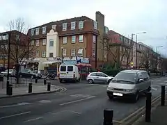 Manor Road, junction with Memorial Avenue. | |
 West Ham Location within Greater London | |
| Population | 15,551 (2011 Census, Ward)[1] |
| OS grid reference | TQ405837 |
| • Charing Cross | 6.1 mi (9.8 km) WSW |
| London borough | |
| Ceremonial county | Greater London |
| Region | |
| Country | England |
| Sovereign state | United Kingdom |
| Post town | LONDON |
| Postcode district | E3, E13, E15 |
| Dialling code | 020 |
| Police | Metropolitan |
| Fire | London |
| Ambulance | London |
| UK Parliament | |
| London Assembly | |
The area, which lies immediately to the north of the River Thames and east of the River Lea, was originally a manor in the county of Essex, then an ancient parish and ultimately a county borough. West Ham was an administrative unit, with largely consistent boundaries, from the 12th century to the formation of Newham in 1965.
History
Ham(me): Pre-partition origins & toponymy
West Ham appears to have been formed after a sub-division of the manor of ‘Hamme’, sometime in the 12th century,
A settlement in the area named Ham is first recorded as Hamme in an Anglo-Saxon charter of 958 and then in the 1086 Domesday Book as Hame. It is formed from Old English 'hamm' and means 'a dry area of land between rivers or marshland', referring to the location of the settlement within boundaries formed by the rivers Lea, Thames and Roding and their marshes.[2]
North Woolwich seems likely to have been removed from Ham in the aftermath of the Norman Conquest.
The earliest recorded use of West Ham, as distinct from East Ham, is in 1186 as Westhamma. The creation of Stratford Langthorne Abbey, and the building of Bow Bridge over the Lea will have increased the prosperity of the area.
The boundary between West and East Ham was drawn from the now lost Hamfrith Waste and Hamfrith Wood in the north (then the southernmost parts of Epping Forest which extended as far south as the Romford Road at that time), along Green Street down to the small, similarly lost, natural harbour known as Ham Creek.
Urbanisation
West Ham underwent rapid growth from 1844 following the Metropolitan Building Act. The Act restricted dangerous and noxious industries from operating in the metropolitan area, the eastern boundary of which was the River Lea. Consequently, many of these activities were relocated to the other side of the river and to West Ham, then a parish in Essex centred on All Saints Church, West Ham. As a result, West Ham became one of Victorian Britain's major manufacturing centres for pharmaceuticals, chemicals, and processed foods. This rapid growth earned it the name "London over the border".[3] The growth of the town was summarised by The Times in 1886:
"Factory after factory was erected on the marshy wastes of Stratford and Plaistow, and it only required the construction at Canning Town of the Victoria and Albert Docks to make the once desolate parish of West Ham a manufacturing and commercial centre of the first importance and to bring upon it a teeming and an industrious population."[3]
Many workers lived in slum conditions close to where they worked, leading to periodic outbreaks of contagious diseases and severe poverty.
First World War – West Ham Pals
In the First World War, the Mayor and Borough of West Ham raised a pals battalion of local volunteers, the 13th (Service) Battalion (West Ham) of the Essex Regiment.
The West Ham Pals were assigned to the 6th Infantry Brigade of the 2nd Infantry Division and served on the Western Front.[4]
Second World War
The presence of the Royal Docks, the Stratford railway lands and other high value targets made the Borough of West Ham one of the areas of London worst effected by bombing during the Second World War. There were officially 1186 civilians killed,[5] but this may have been around 500 higher due to the disputed death toll at South Hallsville School.[6]
Administrative history
Local Government – Ancient Parish
West Ham formed a large ancient parish of around 4,500 acres (18 km2) in the Becontree hundred of Essex. The parish was made up of three wards: Church-street, Stratford-Langthorne, and Plaistow. The parish also included the hamlet of Upton.

Initial administrative response to urbanisation
In 1840 the parish was included in the Metropolitan Police District soon after the built-up area of London had encompassed much of West Ham.
It had become apparent that local government in the parish of West Ham was not adequate to meet the needs of the area which was divided between the parish vestry, highway board and the Havering and Dagenham Commissioners of Sewers. Problems centred on provision of adequate paving, water supply, fire fighting and control of development. In 1853 a group of ratepayers initiated moves to improve local administration. This led to a public enquiry by Charles Dickens' brother Alfred, a medical officer, who published a report in 1855 severely critical of conditions in the slum areas.[3]
Accordingly, the Public Health Act 1848 was applied to the parish, and a local board of health was formed in 1856. The board had 15 members: 12 elected and 3 nominated by the Commissioners of Sewers.[7]
West Ham was included in the London postal district, established in 1857, but not in the statutory metropolitan area established in 1855 or the County of London established in 1889. Instead, administrative reform was undertaken in the area in much the same way as a large provincial town. A local board was formed in 1856 under the Public Health Act 1848.
In November 1878 the inhabitants of the parish decided to petition the privy council for a charter, incorporating the town as a municipal borough.[8] This was in reaction to proposals to enlarge the area governed by the Metropolitan Board of Works to include adjoining districts with a population of 50,000 or more: the primary aim of incorporation was to prevent the inclusion of West Ham in an enlarged London municipality.[3] This initial application was unsuccessful. However, encouraged by the 1883 incorporation of Croydon, a second petition was submitted in May 1885.[9] Following an inquiry in October 1885, a scheme for the creation of the borough and dissolution of the board of health was made in June and the charter was granted in July 1886.[10][11] A corporation consisting of a mayor, 12 aldermen and 36 councillors replaced the board, with the first elections held on 1 November.[3] The first mayor was John Meeson, head of a local lime burning and cement making firm, and a former chairman of West Ham Local Board.[12]
Local government – County Borough
In 1889 the borough was large enough in terms of population to become a county borough and was outside the area of responsibility of Essex County Council – though still formally within the county. At the time of the 1901 census it was the ninth most populous district in England with a population of 267,308.[4] From 1934 to 1965 it was surrounded by the County Borough of East Ham to the east, the municipal boroughs of Wanstead and Woodford and Leyton to the north, and the metropolitan boroughs of Poplar to the west with the Thames to the south with Greenwich on the far side.
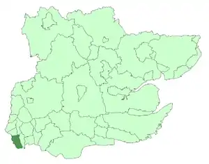
West Ham within Essex in 1961
Coat of arms
The coat of arms was granted by the College of Arms on 14 January 1887. The chevrons on the lower portion represent Stratford, taken from the device of Stratford Langthorne Abbey. At the top right, there are crossed hammers, representing the Thames Ironworks and Shipbuilding Company – the borough's main employer. The ship is representative of the Royal Docks, and the area's long association with the sea. The Latin motto "Deo Confidimus" at the base translates as "In God We Trust."[13]
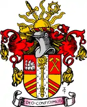
Arms of the county borough corporation
Formation of Newham and inclusion in Greater London
The omission of West Ham from the London-administered metropolitan area, which took in nearby places such as Greenwich and Woolwich, was first commented on in 1855 and West Ham Council later considered the case for inclusion in the County of London in 1895 and 1907.[14] The reluctance to proceed with amalgamation was largely explained by lack of perceived support, fear of financial disadvantage caused by increased rates, the detrimental effect of London planning laws on industry, and the desire to retain the independent civic institutions and privileges attached to county borough status.[14]
The Royal Commission on Local Government in Greater London reviewed the local government arrangements of the Greater London Conurbation and in 1965, under the terms of the London Government Act 1963, the county borough, and the County Borough of East Ham, were abolished and their former area was amalgamated with small parts of Barking and Woolwich to form the London Borough of Newham in Greater London.
Geography
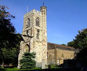
The central West Ham area lies in the centre-west of the wider district; its twin focuses are All Saints' Parish Church and West Ham station. The west of the central area is bounded by the River Lea and is an industrial\post-industrial neighbourhood downstream of the London Olympic Park. The east it is mostly residential, consisting of Victorian terraced housing interspersed with higher density post-war social housing.
Bromley-by-Bow in Tower Hamlets lies to the west of the River Lea and in other directions lie neighbouring parts of the wider West Ham district: to the north and east the area bleeds into Stratford and Plaistow, with Canning Town to the south.
The area has been one of the most deprived in the country and as part of the New Deal for Communities programme it forms, with neighbouring Plaistow, a regeneration area.[15]
Ethnicity
In 1971, individuals of non-European origin comprised approximately 16% of the population of West Ham,[16] rising to approximately 30% by the 1991 census[16] and 65.5% in the 2011 census. In 2011 White British people comprising 19% of the ward's population with Other White individuals forming approximately 15% of the population.[17]
Transport
West Ham station on Manor Road is served by the London Underground Jubilee, Hammersmith and City and District tube lines; the National Rail c2c services; and from 2010 the Docklands Light Railway. Plaistow and Stratford stations are also close by.
Sport
The football club West Ham United F.C. is named after the area. Their nicknames, the Irons and the Hammers derive from their association with the Thames Ironworks and Shipbuilding Company, whose workers formed Thames Ironworks F.C. West Ham United F.C. played at the Boleyn Ground in nearby Upton Park between 1904 and 2016. The West Ham Stadium, a football, greyhound racing and speedway stadium, operated between 1928 and 1972, with a capacity of 120,000. The street names of housing developed on the site of the former stadium pay homage to the speedway greats associated with West Ham, including Bluey Wilkinson and Jack Young. The West Ham Hammers team were involved in the top flight leagues 1929 to 1939, 1946 to 1955 and 1964 to 1971, winning the inaugural British League in 1965.[18]
While football is probably the main focus for the community, there is quite a lot of interest in other sports—with rugby being one of them. Next to West Ham station, on Holland Road, is the home of 3 rugby teams, all playing in Essex RFU leagues: Phantoms RFC, Kings Cross Steelers and East London RFC.
Notable people
- Lennox Lewis, boxer and last undisputed world heavyweight champion
- Leon Greene, opera singer and actor.
- Allan Levene, information technology specialist[19]
- Glen Murphy, actor, producer.
- Colin Towns, composer and keyboardist
- Joseph Lister, antiseptic surgeon[20]
- Martin Peters, footballer and World Cup winner
- Mark Noble, footballer
- Alan Curbishley, footballer and football manager
- Chris Hughton, footballer and football manager
- Ted Fenton, footballer and football manager
- Ernie Gregory, footballer
- Christine Ohuruogu, athlete
- Ronnie Irani, cricketer
- David Essex, musician
- Sol Campbell, footballer
- Tony Cottee, footballer
- Rob Lee, footballer
- Gerard Manley Hopkins, poet
- Leslie Bray (1895–1957), cricketer and officer in the British Army and Royal Air Force
- Margaret Tyzack, actress
References
- UK Census (2011). "Local Area Report – West Ham 2011 Census Ward (1237320157)". Nomis. Office for National Statistics. Retrieved 18 March 2018.
- Mills, A.D. (2001). Dictionary of London Place Names. Oxford.
- "The Incorporation of West Ham". The Times. 1 November 1886. p. 12.
- Up the Hammers" The West Ham Battalion in the Great War 1914–1918, by Elliot Taylor and Barney Alston.
- Commonwealth War Graves site https://www.cwgc.org/visit-us/find-cemeteries-memorials/cemetery-details/4004016/WEST%20HAM,%20COUNTY%20BOROUGH/
- Daily Mirror article on the incident and the disputed death toll https://www.mirror.co.uk/news/uk-news/blitz-bomb-killed-600-in-school-248302
- W R Powell (ed.) (1973). "West Ham – Local government and public services". A History of the County of Essex, Vol.6. Retrieved 22 June 2008.CS1 maint: extra text: authors list (link)
- "No. 24651". The London Gazette. 29 November 1878. p. 6695.
- "No. 25472". The London Gazette. 22 May 1885. p. 2366.
- "No. 25596". The London Gazette. 11 June 1886. pp. 2797–2798.
- "The Incorporation Of West Ham". The Times. 23 June 1886. p. 6.
- "John Meeson, first Mayor of West Ham, 1886-7". The Newham Story. Newham Council. Retrieved 3 November 2009.
- "The Newham story, Coat of Arms (3) – West Ham". Newham London. Retrieved 5 March 2013.
- Local administration and public services: Administrative bodies, A History of the County of Essex: Volume 5 (1966), pp. 32–37. Date accessed: 7 December 2007.
- West Ham and Plaistow New Deal for Communities: All About NDC
- "Changing Landscapes: Four Superdiverse City Wards Stratford and New Town, Newham, (London)" (PDF). Retrieved 9 May 2020.
- "Census Data: West Ham". Office of National Statistics.
- Speedway information on West Ham accessed 11 May 2007
- "US Congress candidate Allan Levene's humble beginnings in West Ham – News". Newham Recorder. 26 February 2012. Retrieved 24 January 2014.
- Pewsey, Stephen (1996). Stratford, West Ham & The Royal Docks. Sutton Publishing. p. 34. ISBN 0-7509-1417-3.
Sources
- Jim Clifford. West Ham and the River Lea: A Social and Environmental History of London's Industrialized Marshland, 1839-1914. Vancouver. University of British Columbia Press, 2017.