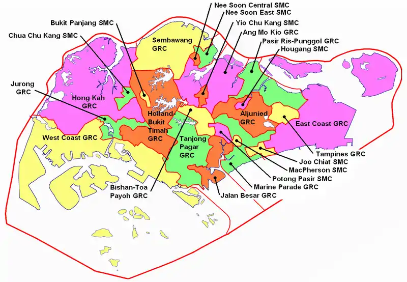
List of Singaporean electoral divisions (2006–11)
The following is a list of Singaporean electoral divisions from 2006 to 2011 that served as constituencies that elected Members of Parliament (MPs) to the 11th Parliament of Singapore in the 2006 Singaporean general election.[1] Each electoral division is further subdivided into polling districts.[2]

Singapore Electoral Boundaries in 2006
Group Representation Constituencies
| Constituency | Seats | Minority representation |
Electorate | Polling Districts |
Wards |
|---|---|---|---|---|---|
| Aljunied GRC | 5 | Malay | 145,141 | 52 | Aljunied–Hougang |
| Bedok Reservoir–Punggol | |||||
| Eunos | |||||
| Paya Lebar | |||||
| Serangoon | |||||
| Ang Mo Kio GRC | 6 | Indian or other | 159,872 | 53 | Cheng San–Seletar |
| Jalan Kayu | |||||
| Kebun Baru | |||||
| Nee Soon South | |||||
| Sengkang West | |||||
| Teck Ghee | |||||
| Bishan–Toa Payoh GRC | 5 | Malay | 115,323 | 39 | Bishan–Toa Payoh North |
| Bishan East | |||||
| Thomson | |||||
| Toa Payoh Central | |||||
| Toa Payoh East | |||||
| East Coast GRC | 5 | Malay | 116,653 | 40 | Bedok |
| Changi–Simei | |||||
| Fengshan | |||||
| Kampong Chai Chee | |||||
| Siglap | |||||
| Holland–Bukit Timah GRC | 5 | Indian or other | 118,155 | 38 | Bukit Timah |
| Buona Vista | |||||
| Cashew | |||||
| Ulu Pandan | |||||
| Zhenghua | |||||
| Hong Kah GRC | 5 | Malay | 144,677 | 46 | Bukit Gombak |
| Hong Kah North | |||||
| Keat Hong | |||||
| Nanyang | |||||
| Yew Tee | |||||
| Jalan Besar GRC | 5 | Malay | 93,025 | 39 | Jalan Besar |
| Kampong Glam | |||||
| Kolam Ayer | |||||
| Kreta Ayer–Kim Seng | |||||
| Whampoa | |||||
| Jurong GRC | 5 | Malay | 116,636 | 39 | Bukit Batok |
| Bukit Batok East | |||||
| Jurong Central | |||||
| Taman Jurong | |||||
| Yuhua | |||||
| Marine Parade GRC | 6 | Malay | 155,149 | 53 | Braddell Heights |
| Geylang Serai | |||||
| Kaki Bukit | |||||
| Kampong Ubi–Kembangan | |||||
| Marine Parade | |||||
| Mountbatten | |||||
| Pasir Ris–Punggol GRC | 6 | Malay | 178,443 | 63 | Pasir Ris East |
| Pasir Ris West | |||||
| Punggol Central | |||||
| Punggol East | |||||
| Punggol North | |||||
| Punggol South | |||||
| Sembawang GRC | 6 | Indian or other | 184,804 | 57 | Admiralty |
| Canberra | |||||
| Chong Pang | |||||
| Marsiling | |||||
| Sembawang | |||||
| Woodlands | |||||
| Tampines GRC | 5 | Malay | 126,163 | 43 | Tampines–Changkat |
| Tampines Central | |||||
| Tampines East | |||||
| Tampines North | |||||
| Tampines West | |||||
| Tanjong Pagar GRC | 6 | Indian or other | 148,141 | 50 | Moulmein |
| Queenstown | |||||
| Radin Mas | |||||
| Tanglin–Cairnhill | |||||
| Tanjong Pagar | |||||
| Tiong Bahru | |||||
| West Coast GRC | 5 | Indian or other | 137,739 | 47 | Ayer Rajah–West Coast |
| Boon Lay | |||||
| Clementi | |||||
| Pioneer | |||||
| Telok Blangah |
Single Member Constituencies
| Constituency | Seats | Electorate | Polling Districts |
|---|---|---|---|
| Bukit Panjang SMC | 1 | 30,452 | 11 |
| Chua Chu Kang SMC | 1 | 24,975 | 9 |
| Hougang SMC | 1 | 23,759 | 8 |
| Joo Chiat SMC | 1 | 21,858 | 9 |
| MacPherson SMC | 1 | 21,041 | 8 |
| Nee Soon Central SMC | 1 | 23,152 | 8 |
| Nee Soon East SMC | 1 | 32,586 | 11 |
| Potong Pasir SMC | 1 | 15,888 | 5 |
| Yio Chu Kang SMC | 1 | 25,072 | 19 |
References
- "Singapore Elections - Map of Electoral Divisions". Singapore Government. 19 February 2008. Archived from the original on 19 February 2008. Retrieved 26 June 2020.
- "Boundaries of Altered Polling Districts" (PDF). www.elections.gov.sg. 24 September 2004. Archived from the original (PDF) on 17 July 2012. Retrieved 26 June 2020.
This article is issued from Wikipedia. The text is licensed under Creative Commons - Attribution - Sharealike. Additional terms may apply for the media files.