Little Bernera
Little Bernera (Scottish Gaelic: Beàrnaraigh Beag) is a small island situated off the west coast of the Isle of Lewis in the Outer Hebrides.
| Scottish Gaelic name | Beàrnaraigh Beag |
|---|---|
| Old Norse name | bjarnar-øy |
| Meaning of name | Bjørn's island, from Norse |
| Location | |
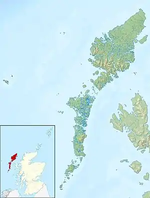 Little Bernera Little Bernera shown within the Outer Hebrides | |
| OS grid reference | NB142410 |
| Coordinates | 58.27°N 6.87°W |
| Physical geography | |
| Island group | Lewis |
| Area | 138 ha |
| Area rank | 129= [1] |
| Highest elevation | Tordal 41 m |
| Administration | |
| Sovereign state | United Kingdom |
| Country | Scotland |
| Council area | Outer Hebrides |
| Demographics | |
| Population | 0 |
| References | [2][3][4][5] |
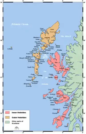
Little Bernera lies between the sea lochs of West and East Loch Roag, immediately to the north of Great Bernera. The island rises to a height of 42 metres (138 feet) and has an area of 138 ha.
The island has evidence of continuous settlement for centuries notably in the remains of former dwellings and chapels. The last tenants were forcibly evicted in 1825 when the island was turned into a satellite of Linshader farm. Following the clearance of the island the only habitable building as noted on the first edition of the Ordnance Survey was the slated fish curing-house.
The island also contained a school set up by the SSPCK.
A few centuries ago, the island was the place where people of Carloway were buried, before a cemetery was built in that village. Today, gravestones can still be seen on the island, but are beginning to disappear into the ground.
At Tràigh an Teampaill, there is the ruined chapel of St Michael and an adjacent cemetery. The island is also the site of the former chapel of St Dondans of which no trace remains but is generally believed to be sited in the very north-west near Mol Mòr.
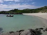
The west of the island is extremely rugged and differs significantly from the machair land of the eastern side which benefits from the blown shell sand of the picturesque beaches of Tràigh Mhòr and Tràigh na Teampuill.
Notes and references
- Area and population ranks: there are c. 300 islands over 20 ha in extent and 93 permanently inhabited islands were listed in the 2011 census.
- National Records of Scotland (15 August 2013). "Appendix 2: Population and households on Scotland's Inhabited Islands" (PDF). Statistical Bulletin: 2011 Census: First Results on Population and Household Estimates for Scotland Release 1C (Part Two) (PDF) (Report). SG/2013/126. Retrieved 14 August 2020.
- Haswell-Smith, Hamish (2004). The Scottish Islands. Edinburgh: Canongate. ISBN 978-1-84195-454-7.
- Ordnance Survey. OS Maps Online (Map). 1:25,000. Leisure.
- Mac an Tàilleir, Iain (2003) Ainmean-àite/Placenames. (pdf) Pàrlamaid na h-Alba. Retrieved 26 August 2012.
| Inhabited islands | ||
|---|---|---|
| Other islands | ||
| Settlements |
| |
| Districts | ||
| Geographical features | ||
| Historical sites | ||