Los Osos, California
Los Osos is an unincorporated community and a census-designated place[2] located along the Pacific coast of San Luis Obispo County, California. The community is part of the 93402 and 93412 ZIP codes and area code 805. The population was 14,276 at the 2010 census.
Los Osos | |
|---|---|
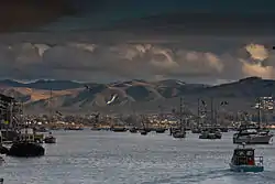 View of Los Osos from Morro Bay harbor | |
 Los Osos Location within the state of California | |
| Coordinates: 35°19′21″N 120°49′53″W | |
| Country | |
| State | |
| County | San Luis Obispo |
| Government | |
| • Type | County Government |
| Area | |
| • Total | 12.783 sq mi (33.110 km2) |
| • Land | 12.763 sq mi (33.057 km2) |
| • Water | 0.020 sq mi (0.053 km2) 0.16% |
| Elevation | 200 ft (60 m) |
| Population (2010) | |
| • Total | 14,276 |
| • Density | 1,100/sq mi (430/km2) |
| Time zone | UTC−8 (Pacific (PST)) |
| • Summer (DST) | UTC−7 (PDT) |
| ZIP codes | 93402 and 93412 |
| Area code | 805 |
| GNIS feature ID | 2407812 |
Geography and ecology
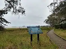
Los Osos is located at 35°19'0" North, 120°50'8" West (35.316795, -120.835605).[3] The 90 acre Elfin Forest and the 32 acre Sweet Springs Nature Preserve[4] are notable natural areas in Los Osos.
Description
Los Osos is largely a bedroom community for San Luis Obispo, which is 10.6 miles (17.1 km) east, and to a lesser extent, Morro Bay, which is 2.3 miles (3.7 km) to the north. There is a small business district concentrated in just a few blocks along Los Osos Valley Road, and several shops servicing the Baywood section of Los Osos, near the bay. The rest of the town is almost entirely residential. Its population is approximately 16,000 and total population at build-out is limited to approximately 26,000.
There are two roads connecting Los Osos to other communities: South Bay Boulevard, which leads to Morro Bay via Highway 1, and Los Osos Valley Road, which leads to San Luis Obispo. Inclement weather and road construction occasionally forces the closure of a route, possibly requiring detours to arrive at one's destination. This has been much less frequent since the Chorro Bridge replaced the Twin Bridges on South Bay Boulevard.
The area is served by a single hourly bus route: San Luis Obispo Regional Transit Authority Route 12. It provides local service on a loop of the town, then express service to Morro Bay, Cuesta College and San Luis Obispo.[5]
Los Osos serves as the entrance to Montaña de Oro State Park. Los Osos Valley Road reaches the coast at the south end of Estero Bay and continues south into the state park. Morro Bay State Park borders the northeast of the town. South Bay Boulevard travels through the middle of the park after it leaves Los Osos. Los Osos is also home to the Elfin Forest [6] which sits on the southeast side of the estuary that sits between Los Osos and Morro Bay State Park.
Large groves of eucalyptus [7] trees attract the annually migrating monarch butterflies to Los Osos.
Los Osos' proximity to the Diablo Canyon Power Plant means that warning sirens are located throughout the town so that the residents will be warned if the power plant should suffer a meltdown or other adverse event. The sirens are also found in other cities nearby, including Morro Bay, San Luis Obispo and Avila Beach. Except for yearly tests, the sirens go largely unused and unnoticed.
Geography
According to the United States Census Bureau, the CDP covers an area of 12.8 square miles (33.1 km2), 99.84% of it land, and 0.16% of it water.
Climate
Los Osos experiences a mild warm-summer Mediterranean climate (Köppen Csb) characteristic of coastal California featuring dry, warm summers and wet, mild winters. The city is located next to the Pacific Ocean, which helps moderate temperatures and create an overall pleasant mild year-round climate, resulting in warmer winters and cooler summers compared with places farther inland, such as Atascadero. Summers are cool for a city located on the 35th parallel north latitude, with July averaging around 60 °F (16 °C). Winters are mild, with January averaging at 55 °F (13 °C) with around 8 days of measurable precipitation.
| Climate data for Los Osos (Morro Bay, CA (1981–2010 normals, extremes 1959–present) | |||||||||||||
|---|---|---|---|---|---|---|---|---|---|---|---|---|---|
| Month | Jan | Feb | Mar | Apr | May | Jun | Jul | Aug | Sep | Oct | Nov | Dec | Year |
| Record high °F (°C) | 89 (32) |
87 (31) |
92 (33) |
100 (38) |
98 (37) |
86 (30) |
92 (33) |
94 (34) |
101 (38) |
106 (41) |
92 (33) |
81 (27) |
106 (41) |
| Average high °F (°C) | 65.0 (18.3) |
65.6 (18.7) |
66.4 (19.1) |
66.7 (19.3) |
65.7 (18.7) |
66.9 (19.4) |
68.1 (20.1) |
69.1 (20.6) |
70.5 (21.4) |
71.4 (21.9) |
69.2 (20.7) |
64.8 (18.2) |
67.4 (19.7) |
| Daily mean °F (°C) | 54.8 (12.7) |
55.9 (13.3) |
56.8 (13.8) |
57.2 (14.0) |
57.9 (14.4) |
59.7 (15.4) |
61.6 (16.4) |
62.3 (16.8) |
62.5 (16.9) |
61.8 (16.6) |
58.8 (14.9) |
54.6 (12.6) |
58.7 (14.8) |
| Average low °F (°C) | 44.6 (7.0) |
46.2 (7.9) |
47.3 (8.5) |
47.7 (8.7) |
50.2 (10.1) |
52.5 (11.4) |
55.0 (12.8) |
55.6 (13.1) |
54.6 (12.6) |
52.2 (11.2) |
48.5 (9.2) |
44.5 (6.9) |
49.9 (9.9) |
| Record low °F (°C) | 23 (−5) |
22 (−6) |
28 (−2) |
31 (−1) |
33 (1) |
39 (4) |
40 (4) |
40 (4) |
41 (5) |
36 (2) |
31 (−1) |
22 (−6) |
22 (−6) |
| Average precipitation inches (mm) | 3.57 (91) |
3.77 (96) |
3.29 (84) |
1.10 (28) |
0.43 (11) |
0.08 (2.0) |
0.01 (0.25) |
0.05 (1.3) |
0.24 (6.1) |
0.82 (21) |
1.40 (36) |
2.72 (69) |
17.48 (444) |
| Average precipitation days (≥ 0.01 in) | 7.8 | 9.2 | 7.8 | 4.9 | 1.7 | 0.6 | 0.4 | 0.5 | 1.5 | 3.0 | 5.0 | 7.1 | 49.5 |
| Source: NOAA[8][9] | |||||||||||||
Demographics
Los Osos was combined with the adjoining unincorporated area of Baywood Park to form the census-designated place of Baywood-Los Osos, but they were split into separate CDPs for the 2010 census. The 2010 United States Census[10] reported that Los Osos had a population of 14,276. The population density was 1,116.7 people per square mile (431.2/km2). The racial makeup of Los Osos was 12,304 (86.2%) White, 79 (0.6%) African American, 97 (0.7%) Native American, 748 (5.2%) Asian, 18 (0.1%) Pacific Islander, 552 (3.9%) from other races, and 478 (3.3%) from two or more races. Hispanic or Latino of any race were 1,977 persons (13.8%).
The Census reported that 14,191 people (99.4% of the population) lived in households, 74 (0.5%) lived in non-institutionalized group quarters, and 11 (0.1%) were institutionalized.
There were 5,958 households, out of which 1,537 (25.8%) had children under the age of 18 living in them, 3,039 (51.0%) were opposite-sex married couples living together, 545 (9.1%) had a female householder with no husband present, 252 (4.2%) had a male householder with no wife present. There were 315 (5.3%) unmarried opposite-sex partnerships, and 67 (1.1%) same-sex married couples or partnerships. 1,595 households (26.8%) were made up of individuals, and 717 (12.0%) had someone living alone who was 65 years of age or older. The average household size was 2.38. There were 3,836 families (64.4% of all households); the average family size was 2.86.
The population was spread out, with 2,557 people (17.9%) under the age of 18, 1,162 people (8.1%) aged 18 to 24, 3,056 people (21.4%) aged 25 to 44, 4,827 people (33.8%) aged 45 to 64, and 2,674 people (18.7%) who were 65 years of age or older. The median age was 47.2 years. For every 100 females, there were 95.5 males. For every 100 females age 18 and over, there were 92.6 males.
There were 6,488 housing units at an average density of 507.5 per square mile (196.0/km2), of which 4,034 (67.7%) were owner-occupied, and 1,924 (32.3%) were occupied by renters. The homeowner vacancy rate was 1.3%; the rental vacancy rate was 4.7%. 9,345 people (65.5% of the population) lived in owner-occupied housing units and 4,846 people (33.9%) lived in rental housing units.
Education
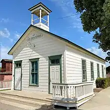
The Los Osos School District and school was founded in 1872. The one room schoolhouse was used until it closed in 1958. The restored schoolhouse is now located in the Los Osos Community Park.
Los Osos is part of the San Luis Coastal Unified School District, and is served by these public schools:
- Elementary Schools: Baywood Elementary and Monarch Grove Elementary.[11] A third elementary school, Sunnyside Elementary, has been closed and used for other educational purposes since 2004.[12][13]
- Middle Schools: Los Osos Middle School[14]
- High Schools: Morro Bay High School in Morro Bay or San Luis Obispo High School in San Luis Obispo (Los Osos students are bused to this school in spite of the district generally eliminating high school bus service.[15] )
Total population is in excess of 14,000, making it the most populous coastal community between Point Buchon and Monterey County.
Indigenous Peoples
Northern Chumash people, known in their language as yak titʸu titʸu yak tiłhini, are the first inhabitants of the Los Osos area, as well as much of San Luis Obispo County. The Northern Chumash place name Petpatsu has been identified to be near or within the area of Los Osos.[16] These peoples traditionally rely on the harvesting of fish and shellfish (e.g. Macoma nasuta) from Morro Bay, as well as the harvesting of acorns and vegetables from the surrounding areas. There is a large Northern Chumash archaeological site on a stabilized sand dune in Los Osos dating to at least as early as 1200 CE.[17] The remains of two Northern Chumash people were removed from a site at Sweet Springs Nature Preserve dating to around 1700 BCE, and were later inventoried under NAGPRA and are possibly in the process of repatriation to the individuals' descendants.[18] Cabrillo first encountered the Chumash in the year 1542.[19] Today, Northern Chumash people are as of yet federally unrecognized, but continue to organize themselves under the Northern Chumash Tribal Council, which is headquartered in Los Osos.[20]
Sewer controversy
Since 1983, a section of the community of Los Osos (Prohibition Zone) has been under a septic tank discharge prohibition, Resolution 83-13, issued by the Central Coast Regional Water Quality Control Board because that part of the town's septic tanks are too numerous and concentrated to dissipate nitrates. A building moratorium within the Prohibition Zone became effective in 1989 as part of the discharge prohibition. San Luis Obispo County was the original authority in charge of building the Wastewater Treatment System. Although the design of the County's selected project was nearly complete they were unable to bring the project to fruition. In July 1997, the County appeared before the California Coastal Commission to address an appeal of the construction permit for the project. Due to voiced opposition at the meeting from members of the Los Osos/Baywood Park Community, the Commission postponed its decision until a full hearing could be held. In 1998 an election was held to form the Los Osos Community Services District (LOCSD) by residents as a response to the high cost of the original sewer proposal. The original billing for the sewer of $50 a month in 1984 and is now (2010) estimated to exceed $200 a month with the current estimated cost of construction of the facilities and collection system to be well over $150 million before tax and interest. On January 1, 1999, the District was established and assumed responsibility for constructing the project.
There was also a controversy about where the sewer should be built. A location in the center of Los Osos (once known as the Tri-W site after the names of the previous owners of the property, now called the Mid-Town site), was chosen partly because of a desire for an additional park. The County, Planning Commission and the Coastal Commission approved a sewer at the site after hearing critics' claims.
In August 2005 the LOCSD began building a sewer at the Mid-Town site, contractors began work on the project and were advanced payments from a State Revolving Fund loan. Following a recall election which replaced the majority of the LOCSD board and enactment of an initiative measure that would require relocation of the project, the new board stopped construction of the sewer, and despite a letter warning them of severe consequences from the Regional Water Quality Control Board.
In October 2005, the LOCSD defaulted on a low interest State Revolving Fund loan. The state subsequently refused to disburse additional project funds and demanded immediate repayment of project funds that had dispersed. Project contractors filed lawsuits for more than $23 million in costs and lost profits. The Central Coast Regional Water Quality Control Board has used its enforcement powers to impose fines against the district in the amount of $6.6 million for violation of the discharge prohibition emanating from three LOCSD-owned sites. During February 2006 the Regional Water Quality Control Board, threatened it would begin to issue cease and desist orders to citizens of Los Osos, and may require recipients to pump their septic systems every three years, and to stop using them by 2011.
On August 25, 2006, the district filed for Chapter 9 bankruptcy protection in federal court.[21] While the district had enough money to cover day-to-day needs, it did not have enough money to cover its legal fees and consultant fees. This action stayed the legal actions against the district related to money owed. Contractor lawsuits and other actions seeking monetary damages or claims against the district will be held in abeyance while the district addresses its financial situation. Subsequently, the LOCSD Bankruptcy Plan was approved in 2013. All claimants party to the bankruptcy were paid 45 cents on the dollar. The LOCSD, as the debtor of the Bankruptcy, was required to raise 2.5 million dollars to pay claimants by selling the LOCSD solid water franchise to the County of SLO.
Additionally, legislation has been approved by the California legislature that could return control of construction of the wastewater treatment facility to the County of San Luis Obispo but only after a due diligence period and a resolution by the County to accept the project. The legislation took the project away from the LOCSD. The LOCSD is still providing approximately one half of the town's drinking water, and is in charge of drainage, parks and recreation, street lighting, the contracting of fire, emergency and rescue services as well as solid waste services. The bill, AB 2701, was signed by the governor and went into effect January 1, 2007.[22] A plan has been approved by the County Board of Supervisors, amended by the County Planning Commission pursuant to some of the objections raised by the community and its Community Advisory Council. The California Coastal Commission has denied the County a permit to proceed due to "Substantial Issues" that were cited during an appeals hearing. A De-Novo hearing is still pending. To date (April 2010) with more than $7 million spent the County has not voted to accept the project.
Since April 2010, the County of San Luis Obispo underwent the de Novo hearing referred to above. The project was approved by the California Coastal Commission and given permission to proceed with the project. The County officially accepted the project and construction commenced in early 2015. By November 2017 project construction was complete. To date, all but 210 property owners have connected to the sewer. The remaining few not connected are awaiting low interest loans from the government to proceed with connecting to the sewer. As of May 26, 2020 all property owners within the sewer project area have connected to the sewer.
Origin of name

On September 7 – 8, 1769, the Portolà expedition traveled through the San Luis Obispo area on his way to rediscover the Bay of Monterey. Finding an abundance of bears in the area, his diarist, Padre Juan Crespi, O.F.M., recorded that the name given the area by his soldiers was "Los Osos" (Spanish for "The Bears"). Sources disagree about whether the rest of the Spanish name Crespi recorded was "llano" (plain)[23] or "cañada" (glen).[24] The fact is that it is a broad, flat valley and the community wisely kept only the simplified "Los Osos", thereby avoiding controversy.
The Portolà expedition was the beginning of a push by Spain to explore the northwestern frontier of Las Californias, and to establish both military outposts and missions. The move was intended to counter what were thought to be colonial designs by Russian traders from Alaska and the British fur companies in the Pacific Northwest. (See: Fort Ross, Russian-American Company, Hudson's Bay Company) The Portolà expedition was organized by the Visitadór Generàl of New Spain, José de Gálvez, following up (belatedly) on previous maritime expeditions, most notably that of Sebastián Vizcaíno in 1602-3, who visited and described many points along the coast, including Monterey Bay, Portolà's primary destination.
Notable people
- Art Clokey, famous for his stop motion clay animation like Gumby and Davey and Goliath.
- Jerome Long, drafted by the Kansas City Chiefs in the 7th round in the 2012 NFL draft.
- Robert Osterloh, American actor.
- Alma Ziegler, baseball player for the All-American Girls Professional Baseball League from 1944 to 1954.
- Erik Lindmark, influential death metal musician and record label founder.
See also
- Amphibious Training Base Morro Bay used Los Osos during World War 2
- Elfin Forest Natural Area
- Los Osos Oaks State Natural Reserve
- Baywood-Los Osos, California
References
- U.S. Census Archived 2012-07-02 at the Wayback Machine
- U.S. Geological Survey Geographic Names Information System: Los Osos, California
- "US Gazetteer files: 2010, 2000, and 1990". United States Census Bureau. 2011-02-12. Retrieved 2011-04-23.
- "Sweet Springs Nature Preserve". Morro Coast Audubon Society. Morro Coast Audubon Society. Retrieved 17 January 2020.
- "North Coast & San Luis Obispo Map & Timetable" (PDF). San Luis Obispo Regional Transit Authority. Retrieved 23 July 2020.
- Meyer, Bob. "El Moro Elfin Forest". elfin-forest.org. Retrieved 2016-08-26.
- "The Eucalyptus of California". Archived from the original on 2013-09-30. Retrieved 2013-04-27.
- "NOWData – NOAA Online Weather Data". National Oceanic and Atmospheric Administration. Retrieved September 27, 2015.
- "CA Morro Bay Fire Dept". National Oceanic and Atmospheric Administration. Retrieved September 27, 2015.
- "2010 Census Interactive Population Search: CA - Los Osos CDP". U.S. Census Bureau. Archived from the original on July 15, 2014. Retrieved July 12, 2014.
- "SLCUSD District Boundary Information" (PDF). San Luis Coastal Unified School District ("SLCUSD"). Retrieved 13 April 2014.
- "SLCUSD: Coastal Family Resource Center" (PDF). San Luis Coastal Unified School District ("SLCUSD"). Retrieved 13 April 2014.
- "Wishing Well School: Our Growing School". Archived from the original on 14 April 2014. Retrieved 13 April 2014.
- "Los Osos Middle School". San Luis Coastal Unified School District ("SLCUSD"). Retrieved 13 April 2014.
- "SLCUSD Notice to High School Parents: SLCUSD will not offer bus transportation to most high school students in 2013-2014" (PDF). San Luis Coastal Unified School District ("SLCUSD"). Retrieved 13 April 2014.
- Milliken, Randall; Johnson, John R. (March 2005). "An Ethnogeography of Salinan and Northern Chumash Communities - 1769 to 1810": 56, 100. doi:10.13140/RG.2.1.3742.8562 – via ResearchGate. Cite journal requires
|journal=(help) - C. Michael Hogan, Los Osos Back Bay, Megalithic Portal, editor A. Burnham
- "Notice of Inventory Completion: San Luis Obispo County Archaeological Society, San Luis Obispo, CA, 8104-8105 [2018-03755]".
- "Los Osos history profile" (PDF). Archived from the original (PDF) on 2008-09-17. Retrieved 2008-04-07.
- "Northern Chumash Tribal Council: Today".
- "Los Osos, California Chapter 9 Voluntary Petition" (PDF). PacerMonitor. PacerMonitor. Retrieved 22 June 2016.
- "AB 2701 Assembly Bill - CHAPTERED". leginfo.ca.gov. Retrieved 2020-06-11.
- "Mission San Luis Obispo de Tolosa: Mission History". Retrieved 13 April 2014.
- Bolton, Herbert E. (1927). Fray Juan Crespi: Missionary Explorer on the Pacific Coast, 1769-1774. HathiTrust Digital Library. p. 185. Retrieved July 1, 2014.
External links
| Wikivoyage has a travel guide for Los Osos. |
Municipalities and communities of San Luis Obispo County, California, United States | ||
|---|---|---|
| Cities |  San Luis Obispo County map | |
| CDPs | ||
| Unincorporated communities | ||
| Ghost towns | ||
| ||
| Counties |  | |
|---|---|---|
| Cities and towns 100k-250k | ||
| Cities and towns 25k-100k | ||
| Cities and towns 10k-25k | ||
| Sub-regions | ||
Counties in italics sometimes included in the definition of the Central Coast | ||