Port Hueneme, California
Port Hueneme (/waɪˈniːmi/ wy-NEEM-ee) is a small beach city in Ventura County, California surrounded by the city of Oxnard and the Santa Barbara Channel.[10] The name derives from the Spanish spelling of the Ventureño phrase wene me, meaning "Resting Place". The town's name was officially changed to Port Hueneme in 1939 and was incorporated March 24, 1948. Both the Port of Hueneme and Naval Base Ventura County lie within city limits.
Port Hueneme, California
Hueneme | |
|---|---|
City | |
| City of Port Hueneme | |
 | |
 Location in Ventura County | |
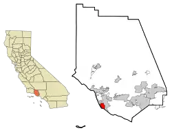
 Port Hueneme Location in Southern California  Port Hueneme Location in California  Port Hueneme Location in the United States | |
| Coordinates: 34°9′37″N 119°11′40″W | |
| Country | |
| State | |
| County | Ventura |
| Wharf constructed | 1871[1] |
| Street grid established | October 1, 1888[2] |
| Incorporated | March 24, 1948[3] |
| Government | |
| • Type | Council-mayor |
| • Mayor | Sylvia Muñoz Schnopp[4] |
| • State senator | Monique Limón (D)[5] |
| • Assemblymember | Jacqui Irwin (D)[5] |
| • U. S. rep. | Julia Brownley (D)[6] |
| Area | |
| • Total | 4.67 sq mi (12.09 km2) |
| • Land | 4.42 sq mi (11.44 km2) |
| • Water | 0.25 sq mi (0.65 km2) 4.70% |
| Elevation | 13 ft (4 m) |
| Population (2010) | |
| • Total | 21,723 |
| • Estimate (2019)[9] | 21,926 |
| • Density | 4,964.00/sq mi (1,916.70/km2) |
| Time zone | UTC-8 (Pacific) |
| • Summer (DST) | UTC-7 (PDT) |
| ZIP codes | 93041–93044 |
| Area code | 805 |
| FIPS code | 06-58296 |
| GNIS feature ID | 1652778 |
| Website | www |
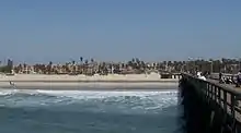
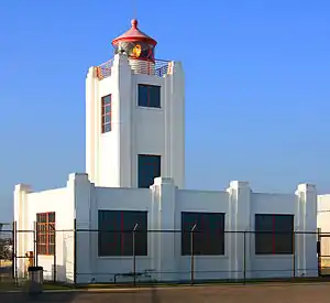
Port Hueneme has a south-facing sand beach, known for its surfing. The beach has a wooden fishing pier[11] and is about a mile long between Ormond Beach[12] downcoast and Point Hueneme Light at the harbor entrance shared by the naval base and the port. The Waterfront Promenade, also known as the Lighthouse Promenade, provides a paved public access along the shoreline with two historic sites at view points: the 1872 Wharf and the Oxnard Packing House.[13][14]
History
Juan Rodríguez Cabrillo explored this area and the adjacent Channel Islands in October 1542.
Thomas Bard learned of the submarine canyon at Point Hueneme[15] and took advantage of the canyon depth to construct the Hueneme Wharf in 1871 here.[1] The existing street grid of the town was formally laid out in 1888.[2] Until the construction of the Montalvo Cutoff that brought the railroad to nearby Oxnard, the wharf was the principal means of transportation for that portion of Ventura County lying south of the Santa Clara River. Hueneme was the second largest grain shipping port on the Pacific coast between 1871 and 1895.[1]
A 650 foot pier was built in 1956 as a construction trestle for a sewer outfall pipeline. The fishing pier is now 1,250 feet long after having been modified over the years.[11]
On January 31, 2000, Alaska Airlines Flight 261 crashed into the Pacific Ocean due to a mechanical failure between Port Hueneme and Anacapa Island. The U.S. Navy Base Ventura County, adjacent to the Port, served as the staging ground for recovery of the wreckage. The victims' families later approved the construction of a memorial sundial, designed by Santa Barbara artist James "Bud" Bottoms, which was placed on the beach closest to the crash site. The names of each of the victims are engraved on individual bronze plates mounted on the perimeter of the dial.[16] The sundial casts a shadow on a memorial plaque at 16:22 each January 31.[17]
Geography
Port Hueneme is located on the southwest portion of the Oxnard Plain at 34°9′37″N 119°11′40″W (34.160250, -119.194509),[18] on the Pacific Ocean.
According to the United States Census Bureau, the city has a total area of 4.7 square miles (12.1 km2). 4.5 square miles (11.5 km2) of it is land and 0.2 square miles (0.6 km2) of it (4.70%) is water.
Climate
This region experiences warm (but not hot) and dry summers, with no average monthly temperatures above 71.6 °F. According to the Köppen Climate Classification system, Port Hueneme has a warm-summer Mediterranean climate, abbreviated "Csb" on climate maps.[19]
Demographics
| Historical population | |||
|---|---|---|---|
| Census | Pop. | %± | |
| 1880 | 166 | — | |
| 1950 | 3,024 | — | |
| 1960 | 11,067 | 266.0% | |
| 1970 | 14,295 | 29.2% | |
| 1980 | 17,803 | 24.5% | |
| 1990 | 20,319 | 14.1% | |
| 2000 | 21,845 | 7.5% | |
| 2010 | 21,723 | −0.6% | |
| 2019 (est.) | 21,926 | [9] | 0.9% |
| U.S. Census Burea[20] | |||
2010
The 2010 United States Census[21] reported that Port Hueneme had a population of 21,723. The population density was 4,651.2 people per square mile (1,795.8/km2). The racial makeup of Port Hueneme was 12,357 (56.9%) White, 1,111 (5.1%) African American, 295 (1.4%) Native American, 1,299 (6.0%) Asian, 119 (0.5%) Pacific Islander, 5,224 (24.0%) from other races, and 1,318 (6.1%) from two or more races. Hispanic or Latino of any race were 11,360 people (52.3%).
The Census reported that 20,854 people (96.0% of the population) lived in households, 869 (4.0%) lived in non-institutionalized group quarters, and 0 (0%) were institutionalized.
There were 7,080 households, out of which 2,832 (40.0%) had children under the age of 18 living in them, 3,267 (46.1%) were opposite-sex married couples living together, 1,121 (15.8%) had a female householder with no husband present, 440 (6.2%) had a male householder with no wife present. There were 458 (6.5%) unmarried opposite-sex partnerships, and 53 (0.7%) same-sex married couples or partnerships. 1,760 households (24.9%) were made up of individuals, and 775 (10.9%) had someone living alone who was 65 years of age or older. The average household size was 2.95. There were 4,828 families (68.2% of all households); the average family size was 3.52.
The population was spread out, with 5,781 people (26.6%) under the age of 18, 2,705 people (12.5%) aged 18 to 24, 6,258 people (28.8%) aged 25 to 44, 4,593 people (21.1%) aged 45 to 64, and 2,386 people (11.0%) who were 65 years of age or older. The median age was 31.3 years. For every 100 females, there were 103.2 males. For every 100 females age 18 and over, there were 101.1 males.
There were 8,131 housing units at an average density of 1,741.0 per square mile (672.2/km2), of which 3,422 (48.3%) were owner-occupied, and 3,658 (51.7%) were occupied by renters. The homeowner vacancy rate was 2.7%; the rental vacancy rate was 6.0%. 9,747 people (44.9% of the population) lived in owner-occupied housing units and 11,107 people (51.1%) lived in rental housing units.
2000
As of the census[22] of 2000, there were 21,845 people, 7,268 households, and 5,000 families residing in the city. The population density was 4,912.9 inhabitants per square mile (1,895.4/km2). There were 7,908 housing units at an average density of 1,778.5 per square mile (686.1/km2). The racial makeup of the city was 57.27% White, 6.06% African American, 1.69% Native American, 6.33% Asian, 0.50% Pacific Islander, 21.84% from other races, and 6.30% from two or more races. Hispanic or Latino of any race were 41.02% of the population.
There were 7,268 households, out of which 37.4% had children under the age of 18 living with them, 49.9% were married couples living together, 13.5% had a female householder with no husband present, and 31.2% were non-families. Twenty-four point one percent of all households were made up of individuals, and 10.3% had someone living alone who was 65 years of age or older. The average household size was 2.86 and the average family size was 3.42.
In the city, the population was spread out, with 27.6% under the age of 18, 13.2% from 18 to 24, 32.0% from 25 to 44, 16.5% from 45 to 64, and 10.7% who were 65 years of age or older. The median age was 30 years. For every 100 females, there were 101.2 males. For every 100 females age 18 and over, there were 100.7 males.
The median income for a household in the city was $42,246, and the median income for a family was $46,056. Males had a median income of $30,314 versus $25,703 for females. The per capita income for the city was $17,311. About 9.8% of families and 12.2% of the population were below the poverty line, including 16.7% of those under age 18 and 8.9% of those age 65 or over.
Economy
The business district is on Channel Islands Boulevard on the north side of the city separated from the original downtown by the Naval base.[23]
Cannabis
Under the legalization of the sale and distribution of cannabis in California, the city developed a model program as the only city in Ventura county to initially allow multiple types of marijuana businesses, including cultivation, manufacturing and retail sales. Local governments may not prohibit adults from growing, using, or transporting marijuana for personal use but commercial activities, such as growing, testing, and selling cannabis within their jurisdiction may be regulated by each city by licensing none or only some of these activities.[24] Five percent of gross revenues from these businesses is collected by the city per agreements that allow them to operate in the city.[25][26]
This has helped with a deficit city budget.[27] The city was able to produce a balanced budget without dipping into reserves in 2019 for the first time in many years partially due to the cannabis revenue.[28] Businesses are required to contribute one percent to community activities.[29] The retail shops are required to have armed security on the premises during hours of operation with some businesses deciding to have a guard nearby 24 hours a day. Security video feed from the shops must be accessible to the police at all times.[24]
By the end of 2018, the city had four recreational marijuana storefronts.[24] As one of the few cities with retail, the city found that about 10 percent of the customers are from Port Hueneme with approximately 50 percent from the adjacent city of Oxnard. About 15 percent were from Camarillo and 10 percent from Ventura with the remaining 15 percent of customers coming from other areas.[24] During a city sponsored workshop in 2019, the chief of the state Bureau of Cannabis Control, which regulates the industry said, “I think you have a lot to be proud of this city. This city has shown if it's done right, it really works well.”[30]
The Port
The Port of Hueneme, shared with Oxnard Harbor District and Naval Base Ventura County, is the only deep water port between the Port of Los Angeles and the Port of San Francisco, and the only Navy controlled harbor between San Diego Bay and Puget Sound in Washington state.[31]
The harbor is a shipping and receiving point for a wide variety of goods destined for the Los Angeles Basin and beyond, including automobiles, pineapples, and bananas. Agricultural products such as onions, strawberries, and flowers are shipped. The city receives about $2 million in tax revenue annually from the port.[32]
In 2014, the beach at Port Hueneme had been eroding for the 60 years since it was built as a commercial port, with jetties that block the natural flow of sand. After the US Navy took over the port during World War II, the government had the responsibility to put back the sand that had disappeared.[33] Funds were lacking until 2013 when it was announced that nearly $12 million in funding would be available to replenish the sand at the beach, the money coming from various branches of the government. Furthermore, there is a continuing, expensive routine to prevent ocean water from sitting on the city streets.[34]
Arts and culture
Hueneme Beach Festival
.jpg.webp)
Since 1998, the city of Port Hueneme holds an annual theme-based beach festival at 550 East Surfside Drive. This 2-day event is held in mid/late August. Entertainment includes live music, rides, games, attractions, food/ vendor booths and exhibits.
Hueneme Harbor Days (Historic)
Prior to the "Hueneme Beach Festival", the HHD Board of Directors ran the 'Port Hueneme Harbor Days Festival & Parade' with food, bands, entertainment, kids attractions, vendor booths, and activities, such as kite-flying contests, sand sculpture contests, metal detection contests, and a long time ago, bathing suit contests. HHB was started in 1950 and ended in 2001, after 51 years of successful operations. The demise came from a lack of city support, and financial troubles such as an increases in fees for insurance, and food handling regulations. There are pictures of the early Hueneme Harbor Days Festival at the local history museum.
Banana Festival
Since 2011, the Port of Hueneme holds the annual Banana Festival on the port grounds. This event is held towards the end of September. The festival includes port tours, live bands, a kids zone, local vendors, and food/drink. Attendees spend the day celebrating the over 3.3 billion bananas that come through the Port of Hueneme each year and have the chance to receive free bananas/banana products from the companies working to transport bananas through the port such as Del Monte and Chiquita. [35]
Sports
This South facing beach offers pitching waves year-round from a multitude of swell directions. As a result of great surf, Port Hueneme surfers are territorial and localism has been known to be a problem.[36]
Education
Public schools
Most of the city of Port Hueneme lies within the boundaries of the Hueneme School District. Portions of the city north of Channel Islands are served by Oxnard Elementary School District.
- Hueneme School District
- [37]
- Oxnard Elementary School District
Hueneme High School of the Oxnard Union High School District serves most of the city. Portions of the city north of Channel Islands are served by Oxnard High School.[49]
Libraries
Public Libraries: Ventura County Library: 14 locations; Port Hueneme branch is the Ray D. Prueter Library.[50] Also nearby is Oxnard Public Library.
Academic Libraries: Oxnard College
References
- Streets, Julie F. (1975(?)). "National Register of Historic Places Inventory/Nomination: Bard, Thomas R., Estate / Berylwood". National Park Service. Check date values in:
|date=(help) - "Plat of Lots in Town of Hueneme" 3 MR 13. Ventura County Recorder Retrieved September 8, 2014 from CountyView GIS.
- "California Cities by Incorporation Date". California Association of Local Agency Formation Commissions. Archived from the original (Word) on February 21, 2013. Retrieved August 25, 2014.
- "City Council". Port Hueneme, CA. Retrieved 16 September 2015.
- "Statewide Database". Regents of the University of California. Archived from the original on February 1, 2015. Retrieved April 17, 2015.
- "California's 26th Congressional District - Representatives & District Map". Civic Impulse, LLC. Retrieved October 5, 2014.
- "2019 U.S. Gazetteer Files". United States Census Bureau. Retrieved July 1, 2020.
- "Port Hueneme". Geographic Names Information System. United States Geological Survey. Retrieved April 17, 2015.
- "Population and Housing Unit Estimates". United States Census Bureau. May 24, 2020. Retrieved May 27, 2020.
- Greenland, Powell. "Port Hueneme." (1994, Ventura County Maritime Museum). ISBN 0870951114.
- Wenner, Gretchen (April 15, 2019). "Will Port Hueneme Pier be renamed Sharkey Pier? City Council to decide". Ventura County Star. Retrieved 2019-04-15.
- U.S. Geological Survey Geographic Names Information System: Ormond Beach
- Klampe, Michelle L. (March 21, 2008) "Waterfront Promenade officially opens today" Ventura County Star
- Cultural Heritage Board. "Ventura County Landmark Map" Archived 2015-10-16 at the Wayback Machine County of Ventura Planning Division Accessed 5 April 2014
- U.S. Geological Survey Geographic Names Information System: Point Hueneme
- "Port Hueneme, CA – Official Website – Alaska Air Flight 261 Memorial Sundial". www.ci.port-hueneme.ca.us. Port Hueneme, CA. Retrieved 14 May 2016.
- Denn, Rebekah. "Memorials quieter today, but Flight 261 grief still hurts". Seattle Post-Intelligencer. Thursday, January 31, 2002. Retrieved February 23, 2009.
- "US Gazetteer files: 2010, 2000, and 1990". United States Census Bureau. 2011-02-12. Retrieved 2011-04-23.
- "Port Hueneme, California Köppen Climate Classification (Weatherbase)". Weatherbase. Retrieved March 31, 2019.
- "Census of Population and Housing". Census.gov. Retrieved June 4, 2015.
- "2010 Census Interactive Population Search: CA - Port Hueneme city". U.S. Census Bureau. Archived from the original on July 15, 2014. Retrieved July 12, 2014.
- "U.S. Census website". United States Census Bureau. Retrieved 2008-01-31.
- Kallas, Anne (August 1, 2016). "Port Hueneme Chamber of Commerce is moving". Ventura County Star. Archived from the original on September 19, 2016. Retrieved September 19, 2016.
- Martinez, Christian (January 2, 2019). "So far, so good for legal marijuana sales in Ventura County". Ventura County Star. Archived from the original on May 4, 2019. Retrieved June 17, 2019.
- Martinez, Arlene (March 27, 2019). "Port Hueneme's marijuana industry has commercial property values blazing". Ventura County Star. Archived from the original on April 5, 2019. Retrieved March 30, 2019.
- Martinez, Arlene. "In an effort to stay on top, Port Hueneme drops some marijuana fees". Ventura County Star. Retrieved 2019-09-21.
- Lehr, Tracy (July 3, 2019). "An exclusive look at Port Hueneme's so-called "Green Mile"". KEYT. Retrieved July 4, 2019.
- Martinez, Arlene (July 20, 2019). "Sales tax plus marijuana proves to be a winning combination in Port Hueneme". Ventura County Star. Archived from the original on 2019-07-30. Retrieved 2019-07-21.
- "Port Hueneme Pot Shops Band Together, Donate $30K To Save Oxnard Fireworks Show". CBS LA. June 6, 2019. Retrieved June 9, 2019.
- Martinez, Arlene (March 30, 2019). "Port Hueneme's police chief lays out the 'State of Cannabis'". Ventura County Star. Archived from the original on March 30, 2019. Retrieved March 30, 2019.
- Commander, Navy Installations Command. "About". Naval Base Ventura County. Retrieved March 31, 2019.
- Lehr, Tracy (2019-03-31). "Wheelhouse Plaza Street Fair highlights "Green Mile" cannabis businesses in Port Hueneme". KEYT. Retrieved 2019-04-01.
- Stallworth, Leo (October 17, 2014). "Port Hueneme Beach erosion: Federal gov't stepping in to help". abc7. Retrieved June 14, 2016.
- "Hueneme Beach erosion has residents concerned". KABC-TV/DT. March 6, 2014. Retrieved June 14, 2016.
- searlecg. "Home". Banana Festival. Retrieved 2020-10-19.
- Weiss, Kenneth (December 24, 1996). "Territorial Surfer Wipes Out". Los Angeles Times. Retrieved March 30, 2019.
- "Boundaries Archived 2016-08-05 at the Wayback Machine". Hueneme School District
- "Richard Bard Elementary School". Archived from the original on June 27, 2012. Retrieved February 25, 2008.
- "Hueneme Elementary School". Archived from the original on June 4, 2016. Retrieved February 25, 2008.
- Parkview Elementary School Archived 2016-08-05 at the Wayback Machine
- Sunkist Elementary School Archived 2016-08-05 at the Wayback Machine
- E.O. Green Junior High School Archived 2008-02-20 at the Wayback Machine
- "Elementary (K-6) Attendance Boundaries". Oxnard Elementary School District
- Marina West Elementary School Archived 2010-10-08 at the Wayback Machine
- McAuliffe Elementary School Archived 2010-06-16 at the Wayback Machine
- "Intermediate (7-8) Attendance Boundaries". Oxnard Elementary School District
- Fremont Intermediate High School Archived 2010-06-15 at the Wayback Machine
- Haydock Junior High School Archived 2009-06-23 at the Wayback Machine
- "Boundaries & Map Archived 2012-02-08 at the Wayback Machine". Oxnard Union High School District
- "Ray D. Prueter Library - Ventura County Library". www.vencolibrary.org. Retrieved 31 March 2019.
External links
| Wikimedia Commons has media related to Port Hueneme, California. |
| Wikivoyage has a travel guide for Port_hueneme. |
Places adjacent to Port Hueneme, California | |
|---|---|
Municipalities and communities of Ventura County, California, United States | ||
|---|---|---|
| Cities | 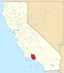 Ventura County map | |
| CDPs | ||
| Unincorporated communities | ||
| Footnotes | ‡This populated place also has portions in an adjacent county or counties | |
| ||
| Counties | 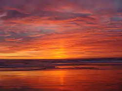 | |
|---|---|---|
| Cities and towns 100k-250k | ||
| Cities and towns 25k-100k | ||
| Cities and towns 10k-25k | ||
| Sub-regions | ||
Counties in italics sometimes included in the definition of the Central Coast | ||
| Authority control |
|---|