Manx Peak
Manx Peak is a 3,044-metre (9,987 ft) mountain summit located in Jasper National Park, in the Trident Range of the Canadian Rockies of Alberta, Canada. The town of Jasper is situated 14 kilometres (8.7 mi) to the north-northeast. Circus Valley lies at the south side of the mountain, and the northeast aspect towers above the head of the valley of Whistlers Creek. Its nearest higher peak is Mount Estella, 1.8 km (1.1 mi) to the southwest, and Terminal Mountain lies 2.0 km (1.2 mi) to the east. The peak is composed of sedimentary rock laid down from the Precambrian to the Jurassic periods and pushed east and over the top of younger rock during the Laramide orogeny.[3]
| Manx Peak | |
|---|---|
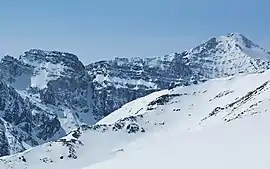 Manx Peak seen from The Whistlers. | |
| Highest point | |
| Elevation | 3,044 m (9,987 ft) [1] |
| Prominence | 374 m (1,227 ft) [1] |
| Parent peak | Mount Estella (3069 m) |
| Coordinates | 52°46′39″N 118°11′30″W [2] |
| Geography | |
 Manx Peak Location of Manx Peak in Alberta  Manx Peak Manx Peak (Canada) | |
| Location | Jasper National Park Alberta, Canada |
| Parent range | Trident Range Canadian Rockies |
| Topo map | NTS 83D/16[2] |
| Climbing | |
| First ascent | 1919 R.T. Chamberlin, B. Herzberg[1] |
History
The peak was named in 1916 by Morrison P. Bridgland because the shape of the contours of the mountain resemble the triskelion in the flag of the Isle of Man, the home of the Manx people.[4] Bridgland (1878–1948), was a Dominion Land Surveyor who named many peaks in Jasper Park and the Canadian Rockies.[5]
The first ascent of Manx Peak was made in 1919 by R.T. Chamberlin and B. Herzberg.[1]
This mountain's name was officially adopted in 1951 by the Geographical Names Board of Canada.[2]
Climate
Based on the Köppen climate classification, Manx Peak is located in a subarctic climate with cold, snowy winters, and mild summers.[6] Temperatures can drop below −20 °C (−4 °F) with wind chill factors below −30 °C (−22 °F). Precipitation runoff from Manx Peak drains into the Athabasca River.
References
- "Manx Peak". Bivouac.com. Retrieved 2019-03-31.
- "Manx Peak". Geographical Names Data Base. Natural Resources Canada. Retrieved 2019-03-31.
- Gadd, Ben (2008). "Geology of the Rocky Mountains and Columbias". Cite journal requires
|journal=(help) - Place-names of Alberta. Ottawa: Geographic Board of Canada. 1928. p. 84.
- Mapper of Mountains M.P. Bridgland in the Canadian Rockies 1902-1930, Author I.S. MacLaren, The University of Alberta Press, ISBN 0-88864-456-6
- Peel, M. C.; Finlayson, B. L.; McMahon, T. A. (2007). "Updated world map of the Köppen−Geiger climate classification". Hydrol. Earth Syst. Sci. 11: 1633–1644. ISSN 1027-5606.
External links
- Parks Canada web site: Jasper National Park
