Marmora and Lake
Marmora and Lake is a municipality along the banks of Crowe River and Beaver Creek, about midway between Toronto and Ottawa on provincial Highway 7 in Hastings County in Central Ontario, Canada.[1] It is home to approximately 4,000 full time and seasonal residents, many of whom enjoy outdoor recreation and relaxation on Crowe Lake.
Marmora and Lake | |
|---|---|
| Municipality of Marmora and Lake | |
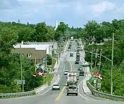
 Municipal office in Marmora | |
 Marmora and Lake Location in southern Ontario | |
| Coordinates: 44°38′33″N 77°44′14″W[1] | |
| Country | |
| Province | |
| County | Hastings |
| Settled | 1821 |
| Incorporated | January 1, 2001 |
| Government | |
| • Type | Municipality |
| • Mayor | Jan O'Neill |
| • Federal riding | Prince Edward—Hastings |
| • Prov. riding | Prince Edward—Hastings |
| Area | |
| • Land | 557.08 km2 (215.09 sq mi) |
| Elevation | 274 m (899 ft) |
| Population (2016)[2] | |
| • Total | 3,953 |
| • Density | 7.1/km2 (18/sq mi) |
| Time zone | UTC-5 (EST) |
| • Summer (DST) | UTC-4 (EDT) |
| Postal Code | K0K 2M0 |
| Area code(s) | 613 and 343 |
| Website | www |
Communities
History
The original township of Marmora was named in 1820 for the Latin word for marble, while the adjoining Township of Lake was named for Viscount Gerard Lake. The two townships were joined to form the single municipality of Marmora and Lake . The village of Marmora separated from the township and was incorporated as a separate municipality in 1901.
Mining played an important role in the development of the area. Iron mining was particularly important in the area. Other minerals extracted from township mines include copper, lead, silver, gold and lithographic limestone. Today, talc and dolomite are processed in the municipality at the site of the former Bethlehem Steel Corporation iron ore open pit mine.
In 1998, the township expanded through an amalgamation of the Village of Deloro.
The current municipality was formed in 2001 through an amalgamation of the Village of Marmora and the existing Township of Marmora and Lake.
Demographics
| Canada census – Marmora and Lake community profile | |||
|---|---|---|---|
| 2016 | 2011 | 2006 | |
| Population: | 3,953 (-3.0% from 2011) | 4,074 (+4.1% from 2006) | 3,912 (-1.8% from 2001) |
| Land area: | 557.08 km2 (215.09 sq mi) | 556.19 km2 (214.75 sq mi) | 533.75 km2 (206.08 sq mi) |
| Population density: | 7.1/km2 (18/sq mi) | 7.3/km2 (19/sq mi) | 7.3/km2 (19/sq mi) |
| Median age: | 54.6 (M: 53.8, F: 55.4) | 50.9 (M: 50.2, F: 51.6) | 48.2 (M: 47.0, F: 49.8) |
| Total private dwellings: | 2,521 | 2,503 | 2,213 |
| Median household income: | $50,586 | $39,743 | |
| References: 2016[4] 2011[5] 2006[6] earlier[7] | |||
According to the 2006 Census,[6] Marmora and Lake has a population of 3,912 permanent residents over an area of 533.75 square kilometres. This is a slight drop from 3,985 recorded in the 2001 census. Private dwellings occupied by usual residents amounted to 1598, whereas total dwellings are 2213. Mother tongue of its population is:
- English as first language: 92.5%
- French as first language: 1.5%
- English and French as first language: 0%
- Other as first language: 6.0%
| Year | Pop. | ±% |
|---|---|---|
| 1996 | 3,874 | — |
| 2001 | 3,985 | +2.9% |
| 2006 | 3,912 | −1.8% |
| 2011 | 4,074 | +4.1% |
| 2016 | 3,953 | −3.0% |
| [8][9][2] | ||
- Population in 1996: 3,874
- Deloro (village): 183
- Marmora (village): 1,483
- Marmora and Lake (township): 2,208
- Population in 1991:
- Deloro (village): 208
- Marmora (village): 1,538
- Marmora and Lake (township): 1,916
Government
Marmora and Lake Council As of 2018:
- Jan O'Neill, Mayor
- Mike Stevens, Deputy Mayor
- Jason Carman, Councillor
- Ron Derry, Councillor
- Bernie Donaldson, Councillor ;
Provincial and federal representation:
- M.P.P. Todd Smith, Progressive Conservative Party of Ontario, for the provincial riding of Prince Edward—Hastings
- M.P. Daryl Kramp, Conservative Party of Canada, for the federal riding of Prince Edward—Hastings
Tourist attractions
- Marmoraton Mine
- Nayler's Common Wetland and Trails
- Eastern Ontario Trails
- Callaghan's Rapids
- Crowe Lake
- Beaver Creek
- MACKFest
Notable Residents
- Greg Terrion - Toronto Maple Leafs hockey player
- Sarah and Rob Skinner - Red Dirt Skinners musical group
Norma Jeanne Laurette and Greg Ceci - Norma Jeanne & Greg Musical Duo, Published Authors and CCS - Canine Correspondence Studies Professional Certification Dog Trainer Career Course with students and graduates in 15 countries.
See also
References
- "Marmora and Lake". Geographical Names Data Base. Natural Resources Canada. Retrieved 2014-06-08.
- "Census Profile, 2016 Census: Marmora and Lake, Municipality". Statistics Canada. Retrieved June 15, 2019.
- Taken from Google Earth at geographic coordinates, accessed 2014-06-08.
- "2016 Community Profiles". 2016 Canadian Census. Statistics Canada. February 21, 2017. Retrieved 2019-06-15.
- "2011 Community Profiles". 2011 Canadian Census. Statistics Canada. July 5, 2013. Retrieved 2014-06-08.
- "2006 Community Profiles". 2006 Canadian Census. Statistics Canada. March 30, 2011. Retrieved 2012-03-02.
- "2001 Community Profiles". 2001 Canadian Census. Statistics Canada. February 17, 2012.
- Statistics Canada: 1996, 2001, 2006 census
- "Marmora and Lake census profile". 2011 Census of Population. Statistics Canada. Retrieved 2012-03-02.
Other map sources:
- Map 6 (PDF) (Map). 1 : 700,000. Official road map of Ontario. Ministry of Transportation of Ontario. 2014. Retrieved 2014-06-08.
- Restructured municipalities - Ontario map #5 (Map). Restructuring Maps of Ontario. Ontario Ministry of Municipal Affairs and Housing. 2006. Retrieved 2014-06-08.
External links
Places adjacent to Marmora and Lake | |
|---|---|
| Cities | 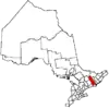 | |
|---|---|---|
| Towns | ||
| Townships | ||
| First Nations | ||
| Indian reserves | ||
| ||