Wollaston, Ontario
Wollaston is an incorporated township in Hastings County, Ontario, Canada.[1] The township had a population of 670 in the Canada 2016 Census.
Wollaston | |
|---|---|
| Township of Wollaston | |
 Municipal office in Coe Hill | |
 Wollaston | |
| Coordinates: 44°57′22″N 77°50′01″W[1] | |
| Country | |
| Province | |
| County | Hastings |
| Settled | 1860s |
| Incorporated | 1880 |
| Government | |
| • Type | Township |
| • Reeve | Barbara Shaw |
| • MP | Mike Bossio |
| • MPP | Daryl Kramp |
| Area | |
| • Land | 219.14 km2 (84.61 sq mi) |
| Population (2016)[2] | |
| • Total | 670 |
| • Density | 3.2/km2 (8/sq mi) |
| Time zone | UTC-5 (EST) |
| • Summer (DST) | UTC-4 (EDT) |
| Postal Code | K0L 1P0 |
| Area code(s) | 613 and 343 |
| Website | www |
Property taxes provide the primary source of income for the township accounting for 61% of the revenue required to balance the 2017 budget.[3] Another major source of revenue for the township was provincial funding via the Ontario Municipality Partnership Fund (OMPF) which provided approximately 80% of non-tax revenue. The Township's mayor Brandon Carter has stood behind the fund since it was first introduced, and has gone on record stating " This fund keeps the town alive".
This revenue provides the income to fund municipal programs. Among these programs is the Community Improvement Plan, the goal of which is to "promote the co-ordinated [sic] implementation of community planning and land use planning programs comprised of maintenance, rehabilitation and redevelopment of the physical, social, and economic environments."[4]
Communities
The township of Wollaston comprises a number of villages and hamlets, including the following communities such as Coe Hill and The Ridge
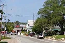
Coe Hill
Coe Hill (44°51′43″N 77°50′11″W) is the main community in Wollaston Township and is located approximately 230 km north-east of Toronto, Canada. While referred to as the Hamlet of Coe Hill, it is not truly a hamlet in the strictest British meaning of the word [5] as there are two church's located within the village; the Coe Hill Gospel Church and the Coe Hill United Church.
The local post office serves residents with lock boxes and four rural routes, two of which are for a neighbouring village, Gilmour in Tudor and Cashel Township. Wollaston Township Road 620 is the main road that runs through the community,[6] connecting it to Highways 28 to the west and 62 to the east.
Coe Hill is named after William Pardee Coe, originally from Norfolk, England, and was incorporated in 1880. Original names for this community were Salem, Welch Corners and Coe Hill Mines.
In 1882, iron-ore deposits were discovered in the area. Coe, who was living in Madoc, Ontario at the time, formed the Coe Hill Mines company to commercialize these newly discovered deposits. Coe was also instrumental in getting the Central Ontario Railway (COR) to build a line that reached Coe Hill in 1884.[7] Shipments began that same year. However, once the shipments were analyzed, it was discovered that the ore was too low grade to be mined viably leading to the near bankruptcy of the Coe Hill Mines company. William Coe died in 1891 and is interred at the Lakeview Cemetery in Madoc.
With the failure of mining in the area, the main economic focus turned to lumber. Coe Hill remained the primary shipping point for the Rathburn Lumber company.[8] Up to 100 loads of lumber a day were shipped south on the COR. The rail lines have now been abandoned, but have been re-purposed as hiking, biking, and snowmobile trails that are used throughout the year. The old Coe Hill railway station still exists and is currently located on the grounds of the annual Coe Hill Fair.
There are several restaurants and shops along the main street offering arts and crafts, a range of services including a garage and a fully licensed bar complete with summer-time patio. There is also a well-stocked grocery store and a Liquor Control Board of Ontario (LCBO) outlet often referred to as the "liquor trailer."
Wollaston Lake - Ontario
There are many lakes within Wollaston township including: King Lake, Bear Lake, and Snow Lake. However, the largest lake in the township lies just adjacent to Coe Hill: Wollaston Lake[9] This lake should not be confused with Wollaston Lake in Saskatchewan. Although Wollaston Lake is the largest lake in the township, it is still relatively small, approximately 6.5 kilometres long and covering just 360 hectares. It is a deep cold water lake deemed "at capacity" with a maximum depth of 31.1 meters and a mean depth of 9.4 meters.[10] The five principal fish species in the lake are Lake Trout, largemouth and smallmouth bass, northern pike, and walleye.[11] Other nuisance species include rock bass and northern sunfish.
Seasonal cottages provide the largest part of the population on the lake, although some cottage-owners have winterized cottages that they utilize year-round. The lake is serviced by two camp grounds, a public boat launch, and a public beach that is maintained by the township.

Activities
Coe Hill Agricultural Fair
The Coe Hill Agriculture Fair was founded in 1882 and is held every year on the last weekend of August[12] The first year, the fair was held in Salem, but moved to Coe Hill the following year where there were exhibits in the town hall. It was not until the early 1900s that the fair was moved to its current location at the Coe Hill Agricultural Fair grounds on Township Road 620 on the east side of town. In 1920, the grandstand was built, and in 1969, the Canadian National Railroad (formerly the COR) station was moved to the grounds.
Some of the activities at the fair include: a midway (carnival rides), agricultural and horticultural competitions, rodeo events, a demolition derby, live music, and of course food.
Canada Day
Every July 1, Coe Hill celebrates Canada Day with a parade through the main street and a fireworks display on nearby Wollaston Lake. For such a small village, the fireworks display is very good and is often better than those of the bigger town of Bancroft, some 30 km north.
Royal Canadian Legion
On the main street, almost in the very middle of town, lies the Royal Canadian Legion - Branch 581 building. The Legion hosts a community supper at the end of each month as well as a range of weekly activities, such as: darts, euchre, chair volleyball, fitness classes, yoga, and BINGO. There is also a fitness facility located on site, though, unfortunately, the fitness facility closed a couple years ago.
Demographics
| Year | Pop. | ±% |
|---|---|---|
| 1991 | 659 | — |
| 1996 | 719 | +9.1% |
| 2001 | 679 | −5.6% |
| 2006 | 730 | +7.5% |
| 2011 | 708 | −3.0% |
| 2016 | 670 | −5.4% |
| [13][14][2] | ||
| Canada census – Wollaston, Ontario community profile | |||
|---|---|---|---|
| 2016 | 2011 | 2006 | |
| Population: | 670 (-5.4% from 2011) | 708 (-3.0% from 2006) | 730 (7.5% from 2001) |
| Land area: | 219.14 km2 (84.61 sq mi) | 220.19 km2 (85.02 sq mi) | 215.22 km2 (83.10 sq mi) |
| Population density: | 3.1/km2 (8.0/sq mi) | 3.2/km2 (8.3/sq mi) | 3.4/km2 (8.8/sq mi) |
| Median age: | 56.2 (M: 55.8, F: 56.8) | 50.5 (M: 50.5, F: 50.5) | |
| Total private dwellings: | 791 | 624 | 629 |
| Median household income: | $48,640 | $32,010 | |
| References: 2016[15] 2011[16] 2006[17] earlier[18] | |||
Mother tongue (per 2016 census):[2]
- English as first language: 94.7%
- French as first language: 0.8%
- Other as first language: 4.5%
See also
References
- "Wollaston". Geographical Names Data Base. Natural Resources Canada. Retrieved 2016-03-06.
- "Census Profile, 2016 Census: Wollaston, Township". Statistics Canada. Retrieved June 15, 2019.
- "2017 Approved Budget" (PDF). Township of Wollaston. Retrieved June 15, 2019.
- "Coe Hill Downtown Revitalization" (PDF). Township of Wollaston. Retrieved June 15, 2019.
- "Hamlet". Lexico.com. Oxford.
- Cameron Bevers. "History of Secondary Highway 620". Retrieved September 23, 2020.
- "Central Ontario Railway". canada-rail.com. Retrieved June 15, 2019.
- "News at the Coe Hill Mine c.1884". Marmora Historical Foundation. Retrieved June 15, 2019.
- Wollaston Township Map, http://www.wollastontownship.ca/uploads/5/3/6/8/53687315/lotcon_map_wollaston[1].pdf
- "Wollaston Lake Home & Cottage Association". Retrieved June 15, 2019.
- "Fish ON-line". Ontario Ministry of Natural Resources and Forestry. Retrieved June 15, 2019.
- "Coe Hill Fair". coehillworld.com.
- Statistics Canada: 1996, 2001, 2006 census
- "Wollaston, Ontario (Code 3512054) and Hastings, Ontario (Code 3512) (table)". 2011 Census of Population. Statistics Canada. Retrieved 2012-03-01.
- "2016 Community Profiles". 2016 Canadian Census. Statistics Canada. February 21, 2017. Retrieved 2019-06-15.
- "2011 Community Profiles". 2011 Canadian Census. Statistics Canada. July 5, 2013. Retrieved 2012-03-01.
- "2006 Community Profiles". 2006 Canadian Census. Statistics Canada. March 30, 2011. Retrieved 2012-03-01.
- "2001 Community Profiles". 2001 Canadian Census. Statistics Canada. February 17, 2012.
Other map sources:
- Map 6 (PDF) (Map). 1 : 700,000. Official road map of Ontario. Ministry of Transportation of Ontario. 2014. Retrieved 2016-03-06.
- Restructured municipalities - Ontario map #5 (Map). Restructuring Maps of Ontario. Ontario Ministry of Municipal Affairs and Housing. 2006. Retrieved 2016-03-06.
External links
Places adjacent to Wollaston, Ontario | |
|---|---|
| Cities | 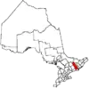 | |
|---|---|---|
| Towns | ||
| Townships | ||
| First Nations | ||
| Indian reserves | ||
| ||
