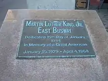
Martin Luther King Jr. East Busway
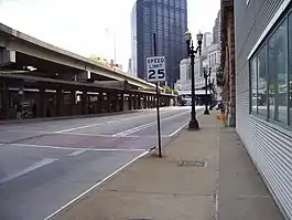
The Martin Luther King Jr. East Busway is a two-lane bus-only highway serving the city of Pittsburgh and many of its eastern neighborhoods and suburbs. It was named after Martin Luther King Jr. in recognition of the eastern portion of the route's serving many predominantly African-American neighborhoods, such as Wilkinsburg and East Liberty. It is owned and maintained by the Port Authority of Allegheny County.
| Martin Luther King Jr. East Busway | |||||||||||||||||||||||||||||||||||||||||||||||||||||||||||||||||||||||||||||||||||||||||||||||||||||||||||||||||||||||||||||||||||||||||||||||||||||||||||||||||||||||||||||||||||||||||||||||||||||||||||||||||||||||||||||||||||||||||||||||||||||||||||||||||||||||||||||||||||||||||||||||||||||||||||||||||||||||||||||||||||||||||||||||||||||||||||||||||||||||||||||||||||||||||||||||||||||||||||||||||||||||||||||||||||||||||||||||||||||||||||||||||||||||||||||||||||||||||||||||||
|---|---|---|---|---|---|---|---|---|---|---|---|---|---|---|---|---|---|---|---|---|---|---|---|---|---|---|---|---|---|---|---|---|---|---|---|---|---|---|---|---|---|---|---|---|---|---|---|---|---|---|---|---|---|---|---|---|---|---|---|---|---|---|---|---|---|---|---|---|---|---|---|---|---|---|---|---|---|---|---|---|---|---|---|---|---|---|---|---|---|---|---|---|---|---|---|---|---|---|---|---|---|---|---|---|---|---|---|---|---|---|---|---|---|---|---|---|---|---|---|---|---|---|---|---|---|---|---|---|---|---|---|---|---|---|---|---|---|---|---|---|---|---|---|---|---|---|---|---|---|---|---|---|---|---|---|---|---|---|---|---|---|---|---|---|---|---|---|---|---|---|---|---|---|---|---|---|---|---|---|---|---|---|---|---|---|---|---|---|---|---|---|---|---|---|---|---|---|---|---|---|---|---|---|---|---|---|---|---|---|---|---|---|---|---|---|---|---|---|---|---|---|---|---|---|---|---|---|---|---|---|---|---|---|---|---|---|---|---|---|---|---|---|---|---|---|---|---|---|---|---|---|---|---|---|---|---|---|---|---|---|---|---|---|---|---|---|---|---|---|---|---|---|---|---|---|---|---|---|---|---|---|---|---|---|---|---|---|---|---|---|---|---|---|---|---|---|---|---|---|---|---|---|---|---|---|---|---|---|---|---|---|---|---|---|---|---|---|---|---|---|---|---|---|---|---|---|---|---|---|---|---|---|---|---|---|---|---|---|---|---|---|---|---|---|---|---|---|---|---|---|---|---|---|---|---|---|---|---|---|---|---|---|---|---|---|---|---|---|---|---|---|---|---|---|---|---|---|---|---|---|---|---|---|---|---|---|---|---|---|---|---|---|---|---|---|---|---|---|---|---|---|---|---|---|---|---|---|---|---|---|---|---|---|---|---|---|---|---|---|---|---|---|---|---|---|---|---|---|---|---|---|---|---|---|---|---|---|---|---|---|---|---|---|---|---|---|---|---|---|---|---|---|---|---|---|---|---|---|---|---|---|---|---|---|---|---|---|---|---|---|---|---|---|---|---|---|---|---|---|---|---|
 | |||||||||||||||||||||||||||||||||||||||||||||||||||||||||||||||||||||||||||||||||||||||||||||||||||||||||||||||||||||||||||||||||||||||||||||||||||||||||||||||||||||||||||||||||||||||||||||||||||||||||||||||||||||||||||||||||||||||||||||||||||||||||||||||||||||||||||||||||||||||||||||||||||||||||||||||||||||||||||||||||||||||||||||||||||||||||||||||||||||||||||||||||||||||||||||||||||||||||||||||||||||||||||||||||||||||||||||||||||||||||||||||||||||||||||||||||||||||||||||||||
| Overview | |||||||||||||||||||||||||||||||||||||||||||||||||||||||||||||||||||||||||||||||||||||||||||||||||||||||||||||||||||||||||||||||||||||||||||||||||||||||||||||||||||||||||||||||||||||||||||||||||||||||||||||||||||||||||||||||||||||||||||||||||||||||||||||||||||||||||||||||||||||||||||||||||||||||||||||||||||||||||||||||||||||||||||||||||||||||||||||||||||||||||||||||||||||||||||||||||||||||||||||||||||||||||||||||||||||||||||||||||||||||||||||||||||||||||||||||||||||||||||||||||
| Owner | Port Authority of Allegheny County | ||||||||||||||||||||||||||||||||||||||||||||||||||||||||||||||||||||||||||||||||||||||||||||||||||||||||||||||||||||||||||||||||||||||||||||||||||||||||||||||||||||||||||||||||||||||||||||||||||||||||||||||||||||||||||||||||||||||||||||||||||||||||||||||||||||||||||||||||||||||||||||||||||||||||||||||||||||||||||||||||||||||||||||||||||||||||||||||||||||||||||||||||||||||||||||||||||||||||||||||||||||||||||||||||||||||||||||||||||||||||||||||||||||||||||||||||||||||||||||||||
| Locale | Pittsburgh | ||||||||||||||||||||||||||||||||||||||||||||||||||||||||||||||||||||||||||||||||||||||||||||||||||||||||||||||||||||||||||||||||||||||||||||||||||||||||||||||||||||||||||||||||||||||||||||||||||||||||||||||||||||||||||||||||||||||||||||||||||||||||||||||||||||||||||||||||||||||||||||||||||||||||||||||||||||||||||||||||||||||||||||||||||||||||||||||||||||||||||||||||||||||||||||||||||||||||||||||||||||||||||||||||||||||||||||||||||||||||||||||||||||||||||||||||||||||||||||||||
| Termini | Penn Station Swissvale | ||||||||||||||||||||||||||||||||||||||||||||||||||||||||||||||||||||||||||||||||||||||||||||||||||||||||||||||||||||||||||||||||||||||||||||||||||||||||||||||||||||||||||||||||||||||||||||||||||||||||||||||||||||||||||||||||||||||||||||||||||||||||||||||||||||||||||||||||||||||||||||||||||||||||||||||||||||||||||||||||||||||||||||||||||||||||||||||||||||||||||||||||||||||||||||||||||||||||||||||||||||||||||||||||||||||||||||||||||||||||||||||||||||||||||||||||||||||||||||||||
| Stations | 10 | ||||||||||||||||||||||||||||||||||||||||||||||||||||||||||||||||||||||||||||||||||||||||||||||||||||||||||||||||||||||||||||||||||||||||||||||||||||||||||||||||||||||||||||||||||||||||||||||||||||||||||||||||||||||||||||||||||||||||||||||||||||||||||||||||||||||||||||||||||||||||||||||||||||||||||||||||||||||||||||||||||||||||||||||||||||||||||||||||||||||||||||||||||||||||||||||||||||||||||||||||||||||||||||||||||||||||||||||||||||||||||||||||||||||||||||||||||||||||||||||||
| Service | |||||||||||||||||||||||||||||||||||||||||||||||||||||||||||||||||||||||||||||||||||||||||||||||||||||||||||||||||||||||||||||||||||||||||||||||||||||||||||||||||||||||||||||||||||||||||||||||||||||||||||||||||||||||||||||||||||||||||||||||||||||||||||||||||||||||||||||||||||||||||||||||||||||||||||||||||||||||||||||||||||||||||||||||||||||||||||||||||||||||||||||||||||||||||||||||||||||||||||||||||||||||||||||||||||||||||||||||||||||||||||||||||||||||||||||||||||||||||||||||||
| Type | Bus rapid transit | ||||||||||||||||||||||||||||||||||||||||||||||||||||||||||||||||||||||||||||||||||||||||||||||||||||||||||||||||||||||||||||||||||||||||||||||||||||||||||||||||||||||||||||||||||||||||||||||||||||||||||||||||||||||||||||||||||||||||||||||||||||||||||||||||||||||||||||||||||||||||||||||||||||||||||||||||||||||||||||||||||||||||||||||||||||||||||||||||||||||||||||||||||||||||||||||||||||||||||||||||||||||||||||||||||||||||||||||||||||||||||||||||||||||||||||||||||||||||||||||||
| Operator(s) | Port Authority of Allegheny County | ||||||||||||||||||||||||||||||||||||||||||||||||||||||||||||||||||||||||||||||||||||||||||||||||||||||||||||||||||||||||||||||||||||||||||||||||||||||||||||||||||||||||||||||||||||||||||||||||||||||||||||||||||||||||||||||||||||||||||||||||||||||||||||||||||||||||||||||||||||||||||||||||||||||||||||||||||||||||||||||||||||||||||||||||||||||||||||||||||||||||||||||||||||||||||||||||||||||||||||||||||||||||||||||||||||||||||||||||||||||||||||||||||||||||||||||||||||||||||||||||
| History | |||||||||||||||||||||||||||||||||||||||||||||||||||||||||||||||||||||||||||||||||||||||||||||||||||||||||||||||||||||||||||||||||||||||||||||||||||||||||||||||||||||||||||||||||||||||||||||||||||||||||||||||||||||||||||||||||||||||||||||||||||||||||||||||||||||||||||||||||||||||||||||||||||||||||||||||||||||||||||||||||||||||||||||||||||||||||||||||||||||||||||||||||||||||||||||||||||||||||||||||||||||||||||||||||||||||||||||||||||||||||||||||||||||||||||||||||||||||||||||||||
| Opened | February 1983 | ||||||||||||||||||||||||||||||||||||||||||||||||||||||||||||||||||||||||||||||||||||||||||||||||||||||||||||||||||||||||||||||||||||||||||||||||||||||||||||||||||||||||||||||||||||||||||||||||||||||||||||||||||||||||||||||||||||||||||||||||||||||||||||||||||||||||||||||||||||||||||||||||||||||||||||||||||||||||||||||||||||||||||||||||||||||||||||||||||||||||||||||||||||||||||||||||||||||||||||||||||||||||||||||||||||||||||||||||||||||||||||||||||||||||||||||||||||||||||||||||
| Technical | |||||||||||||||||||||||||||||||||||||||||||||||||||||||||||||||||||||||||||||||||||||||||||||||||||||||||||||||||||||||||||||||||||||||||||||||||||||||||||||||||||||||||||||||||||||||||||||||||||||||||||||||||||||||||||||||||||||||||||||||||||||||||||||||||||||||||||||||||||||||||||||||||||||||||||||||||||||||||||||||||||||||||||||||||||||||||||||||||||||||||||||||||||||||||||||||||||||||||||||||||||||||||||||||||||||||||||||||||||||||||||||||||||||||||||||||||||||||||||||||||
| Line length | 9.1 mile[1][2] | ||||||||||||||||||||||||||||||||||||||||||||||||||||||||||||||||||||||||||||||||||||||||||||||||||||||||||||||||||||||||||||||||||||||||||||||||||||||||||||||||||||||||||||||||||||||||||||||||||||||||||||||||||||||||||||||||||||||||||||||||||||||||||||||||||||||||||||||||||||||||||||||||||||||||||||||||||||||||||||||||||||||||||||||||||||||||||||||||||||||||||||||||||||||||||||||||||||||||||||||||||||||||||||||||||||||||||||||||||||||||||||||||||||||||||||||||||||||||||||||||
| |||||||||||||||||||||||||||||||||||||||||||||||||||||||||||||||||||||||||||||||||||||||||||||||||||||||||||||||||||||||||||||||||||||||||||||||||||||||||||||||||||||||||||||||||||||||||||||||||||||||||||||||||||||||||||||||||||||||||||||||||||||||||||||||||||||||||||||||||||||||||||||||||||||||||||||||||||||||||||||||||||||||||||||||||||||||||||||||||||||||||||||||||||||||||||||||||||||||||||||||||||||||||||||||||||||||||||||||||||||||||||||||||||||||||||||||||||||||||||||||||
The Institute for Transportation and Development Policy (ITDP), under its BRT Standard, has given the East Busway corridor a Bronze ranking.[3]
History
Originally occupied by a railroad line, planning for the East Busway began shortly after the Port Authority of Allegheny County purchased the Pittsburgh Railways Company in 1964.[4] The original segment of the busway opened in February 1983, running between Downtown Pittsburgh and Edgewood, a length of 6.8 miles.
In 2003, the busway was extended into Swissvale by 2.3 miles (3.7 km), making its current length 9.1 miles (14.6 km).
In July 2013, the East Busway was discussed in the context of the Mon Fayette Expressway. [5]
Routes

Following the naming convention of each busway being designated by a color, bus routes that use the East Busway begin with a "P" for purple. However, the P13 (Mount Royal Flyer) is colored purple and uses a "P" designation, but does not use the busway; instead, it travels via Route 28. The P1 ("East Busway All Stops") is the main route, operating seven days a week and running the full length of the Busway between Swissvale and Downtown Pittsburgh, making all stops, before running a short loop through the central business district. It is the busiest Port Authority bus route by ridership. This route is supplemented by the P2 (East Busway Short), which runs on weekdays only and terminates in Wilkinsburg.
All busway routes travel to downtown Pittsburgh, making a loop around before returning via the busway. The one exception to this is the P3 (East Busway-Oakland), which starts in Swissvale, but leaves the busway via the Neville Street Ramp, serving the business district of Oakland and terminating at Robinson Street.
Many of the Port Authority's express and suburban Flyer routes also use the busway (but do not make stops along it), primarily during weekday rush hours. The busway enables these routes to bypass the heavily congested Parkway East (Interstate 376), making for faster trip times. The East Busway is also used by some Westmoreland Transit routes, which run further into the Pittsburgh suburbs, ending in the cities of Greensburg and Latrobe in Westmoreland County.
As of October 2018, the Port Authority bus routes that use the East Busway are as follows: [6]
| Route Number | Route Name | Destination | Roads Traveled |
|---|---|---|---|
| P1 | East Busway All Stops | Swissvale station | |
| P2 | East Busway Short | Wilkinsburg station | |
| P3 | East Busway-Oakland | 5th Av & Robinson St | Neville St/5th Av |
| P7 | McKeesport Flyer | McKeesport Transportation Center | Edgewood Av/Rankin Blvd/Kennywood Blvd |
| P10 | Allegheny Valley Flyer | Harrison | Route 28/Freeport Rd |
| P12 | Holiday Park Flyer | Holiday Park | Penn Av/Parkway East/Golden Mile Highway |
| P16 | Penn Hills Flyer | Alpha Ice Complex, Harmar | Buses travel either via Leechburg Rd or Universal Rd. |
| P17 | Lincoln Park Flyer | Nadine | Lincoln Av/Mt Carmel Rd |
| P67 | Monroeville Flyer | Monroeville Mall | William Penn Highway |
| P68 | Braddock Hills Flyer | Monroeville Mall | Brinton Rd/Braddock Av/James St |
| P69 | Trafford Flyer | Viaduct Way, Trafford | Ardmore Blvd/Airbrake Av/Broadway Blvd |
| P71 | Swissvale Flyer | Swissvale station | Savannah Av/Braddock Av/Woodstock Av |
| P76 | Lincoln Highway Flyer | Olympia Park and Ride | Ardmore Blvd/Lincoln Hwy/Long Run Rd |
| P78 | Oakmont Flyer | Alpha Ice Complex, Harmar | Laketon Rd/Verona Rd/Allegheny River Blvd |
Stations
| Station Name | Neighborhood/Borough Served | Notes |
|---|---|---|
| Penn Station | Downtown | Connects with Pittsburgh's Union Station (Amtrak and Greyhound connections) |
| Herron | Polish Hill | |
| Negley | Shadyside | |
| East Liberty | East Liberty | |
| Homewood | Homewood, Point Breeze North | |
| Wilkinsburg | Wilkinsburg | 748 space Park and Ride available |
| Hay Street | Wilkinsburg | spur segment of the busway served only by P2 |
| Hamnett | Wilkinsburg | 128 space Park and Ride available |
| Roslyn Street | Swissvale | |
| Swissvale | Swissvale | 163 space Park and Ride available |
References
- http://www.pittsburghtransit.org/busway.html.
- https://usa.streetsblog.org/2011/06/20/profiles-in-american-brt-pittsburghs-south-busway-and-east-busway/.
- "BRT Rankings". Institute for Transportation and Development Policy. 2020. Retrieved April 26, 2020.
- Kitsko, Jeffrey (17 February 2010). "Martin Luther King Jr. East Busway". Pittsburgh Highways. Retrieved 30 July 2013.
- Schmitz, Jon (July 20, 2013). "Leading Mon-Fayette Expressway supporter changes lanes". Pittsburgh Post-Gazette. Retrieved July 25, 2013.
- http://www.portauthority.org/PAAC/Apps/maps/SystemMap.pdf
External links
| Wikimedia Commons has media related to Martin Luther King Jr. East Busway. |
- Port Authority of Allegheny County: East Busway information page
- East Busway Schedule - P1, P2, P3
- East Busway Route Map - P1, P2, P3
| Light rail (List of stations) | .svg.png.webp) | |
|---|---|---|
| Inclines (Historical list) | ||
| Buses and busways (List of routes) | ||
| Former lines | ||
| Other | ||