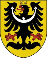
Middle Silesia
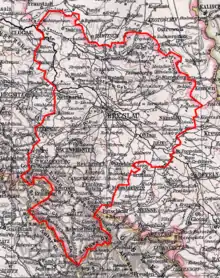
Middle Silesia (German: Mittelschlesien, Polish: Śląsk Środkowy) was a colloquial designation for the Regierungsbezirk Breslau subdivision in the Prussian Province of Silesia from 1813 to 1945. It comprised the eastern parts of the historic Lower Silesia region and the former County of Kladsko, both conquered by Prussia in 1742.
History
Silesia had been part of Bohemian crown lands of the Habsburg Monarchy until most of it was ceded to the Kingdom of Prussia in the First Silesian War, codified by the 1742 Treaty of Breslau. In 1813, the administrative Regierungsbezirk was established in Prussian Silesia, with its capital in Breslau (present-day Wrocław). The western half of Lower Silesia was incorporated into Regierungsbezirk Liegnitz (Legnica), the adjacent Upper Silesian land in the east into Regierungsbezirk Oppeln (Opole).
After the short-lived Regierungsbezirk Reichenbach (Dzierżoniów) was dissolved in 1820, the Middle Silesian district also comprised Glatzer Land (Kłodzko Land) in the south and several districts of the former duchies of Münsterberg (Ziębice), Jauer (Jawor) and Brieg (Brzeg). It then stretched from the Greater Polish plain in the north (Grand Duchy of Posen/Province of Posen) to the border with Bohemia along the Sudetes mountain range in the south, where Glatzer Land also bordered on Austrian Silesia in the east.
After World War I, the state of Czechoslovakia arose on the southern border, while Greater Poland in the north became part of the Second Polish Republic. At the same time, the Prussian Province of Silesia was divided, whereby Regierungsbezirk Breslau formed the eastern half of the Province of Lower Silesia. After World War II, the region became part of Poland, as the Soviet Union expanded its borders and moved Poland westward under the terms of the 1945 Potsdam Agreement. By 1949, almost the entire indigenous German population was expelled.[1]
Today, the region forms the eastern part of the Polish Lower Silesian Voivodeship and the north-western part of the Opole Voivodeship.
Ethnolinguistic structure
In 1819, Regierungsbezirk Breslau had 838,253 inhabitants: 755,553 Germans (90.1%); 66,500 Poles (7.9%); 8,900 Czechs (1.1%) and 7,300 Jews (0.9%).[2] The United States Immigration Commission in 1911 classified Polish-speaking Silesians as ethnic Poles.[3]
According to the Prussian census of 1861, Regierungsbezirk Breslau had a population of 1,278,064, of which 1,217,102 (95.2%) spoke German, 53,479 (4.2%) spoke Polish and 7,483 (0.6%) spoke Czech.[4]
Administrative subdivisions
Before its dissolution in 1945, Regierungsbezirk Breslau comprised the following districts:

Stadtkreise (Urban districts)
- Stadtkreis Breslau
- Stadtkreis Brieg
- Stadtkreis Schweidnitz
- Stadtkreis Waldenburg
Landkreise (Rural districts)
- Landkreis Breslau
- Landkreis Brieg
- Landkreis Frankenstein
- Landkreis Glatz
- Landkreis Groß Wartenberg
- Landkreis Guhrau
- Landkreis Habelschwerdt
- Landkreis Militsch
- Landkreis Namslau
- Landkreis Neumarkt
- Landkreis Oels
- Landkreis Ohlau
- Landkreis Reichenbach (im Eulengebirge)
- Landkreis Schweidnitz
- Landkreis Strehlen
- Landkreis Trebnitz
- Landkreis Waldenburg
- Landkreis Wohlau
References
- Demshuk, Andrew (2014). "The Lost German East: Forced Migration and the Politics of Memory, 1945–1970". History. 99 (334): 53. doi:10.1111/1468-229X.12049_28.
- Georg Hassel (1823). Statistischer Umriß der sämmtlichen europäischen und der vornehmsten außereuropäischen Staaten, in Hinsicht ihrer Entwickelung, Größe, Volksmenge, Finanz- und Militärverfassung, tabellarisch dargestellt; Erster Heft: Welcher die beiden großen Mächte Österreich und Preußen und den Deutschen Staatenbund darstellt (in German). Verlag des Geographischen Instituts Weimar. pp. 33–34.
Nationalverschiedenheit 1819
- Dillingham, William Paul; Folkmar, Daniel; Folkmar, Elnora (1911). Dictionary of Races or Peoples. United States. Immigration Commission (1907-1910). Washington, D.C.: Washington, Government Printing Office. pp. 104–105.
- Belzyt, Leszek (1998). Sprachliche Minderheiten im preussischen Staat: 1815 - 1914 ; die preußische Sprachenstatistik in Bearbeitung und Kommentar. Marburg: Herder-Inst. ISBN 978-3-87969-267-5.