Mount Boswell
Mount Boswell is a 2,454-metre (8,051-foot) summit located in Waterton Lakes National Park, in the Canadian Rockies of Alberta, Canada. It is situated along the east shore of Waterton Lake, one kilometre north of the Canada–United States border. Its nearest higher peak is Miche Wabun Peak, 5.0 km (3.1 mi) to the southeast.[1]
| Mount Boswell | |
|---|---|
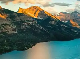 Mount Boswell above Waterton Lake | |
| Highest point | |
| Elevation | 2,454 m (8,051 ft) [1] |
| Prominence | 194 m (636 ft) [1] |
| Parent peak | Miche Wabun Peak (2701 m)[1] |
| Coordinates | 49°00′25″N 113°51′59″W [2] |
| Geography | |
 Mount Boswell Location of Mount Boswell in Alberta  Mount Boswell Mount Boswell (Canada) | |
| Location | Alberta, Canada |
| Parent range | Canadian Rockies |
| Topo map | NTS 82H04[2] |
| Geology | |
| Age of rock | Cambrian |
History
Mount Boswell was named in 1917 for Dr. W.G. Boswell, the veterinarian for the International Boundary Commission.[3][4]
The mountain's name became official in 1943 by the Geographical Names Board of Canada.[2]
Geology
Like other mountains in Waterton Lakes National Park, Mount Boswell is composed of sedimentary rock laid down during the Precambrian to Jurassic periods. Formed in shallow seas, this sedimentary rock was pushed east and over the top of younger Cretaceous period rock during the Laramide orogeny.[5]
Climate
Based on the Köppen climate classification, Mount Boswell is located in a subarctic climate with cold, snowy winters, and mild summers.[6] Temperatures can drop below −20 C with wind chill factors below −30 C. Precipitation runoff from Mount Boswell drains into Waterton Lake, thence Waterton River.
References
- "Mount Boswell". Bivouac.com. Retrieved 2019-01-14.
- "Mount Boswell". Geographical Names Data Base. Natural Resources Canada. Retrieved 2019-01-14.
- Place-names of Alberta. Ottawa: Geographic Board of Canada. 1928. p. 23.
- Mount Boswell PeakFinder
- Gadd, Ben (2008). "Geology of the Rocky Mountains and Columbias". Cite journal requires
|journal=(help) - Peel, M. C.; Finlayson, B. L.; McMahon, T. A. (2007). "Updated world map of the Köppen−Geiger climate classification". Hydrol. Earth Syst. Sci. 11: 1633–1644. ISSN 1027-5606.
External links
- National Park Service web site: Waterton Lakes National Park
- Mount Boswell weather: Mountain Forecast
