Mount Carter (Idaho)
Mount Carter, at 10,590 feet (3,230 m) above sea level is the seventh highest peak in the Sawtooth Range of Idaho. The peak is located in the Sawtooth Wilderness of Sawtooth National Recreation Area on the border of Boise and Custer counties. The peak is located 0.32 mi (0.51 km) northwest of Mickey's Spire, its line parent, and 0.43 mi (0.69 km) west of Thompson Peak, the highest point in the range.[2][3][4]
| Mount Carter | |
|---|---|
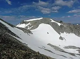 Mount Carter from Thompson Peak | |
| Highest point | |
| Elevation | 10,590 ft (3,230 m) |
| Prominence | 270 ft (82 m) [1] |
| Parent peak | Mickey's Spire |
| Coordinates | 44°08′23″N 115°01′06″W |
| Geography | |
| Parent range | Sawtooth Range |
| Topo map | USGS Stanley Lake |
| Climbing | |
| Easiest route | Scramble, class 3 |
References
- "Mount Carter, Idaho". Peakbagger.com. Retrieved January 3, 2013.
- "Mount Carter". SummitPost.org. Retrieved January 3, 2013.
- "Mount Carter". Lists of John. Retrieved January 3, 2013.
- Sawtooth National Forest (Map) (1998 ed.). Sawtooth National Forest, U.S. Forest Service.
This article is issued from Wikipedia. The text is licensed under Creative Commons - Attribution - Sharealike. Additional terms may apply for the media files.
