Custer County, Idaho
Custer County is a rural mountain county in the center of the U.S. state of Idaho. As of the 2010 census, the population was 4,368.[1] The county seat is Challis.[2] Established in 1881, the county was named for the General Custer Mine, where gold was discovered five years earlier. Custer County relies on ranching, mining, and tourism as its main resources.[3]
Custer County | |
|---|---|
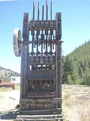 Mill used to process gold and silver ore at Yankee Fork mining operations. | |
 Seal | |
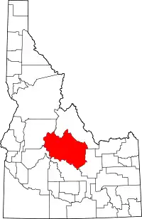 Location within the U.S. state of Idaho | |
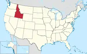 Idaho's location within the U.S. | |
| Coordinates: 44°14′N 114°17′W | |
| Country | |
| State | |
| Founded | January 8, 1881 |
| Named for | General Custer gold mine |
| Seat | Challis |
| Largest city | Challis |
| Area | |
| • Total | 4,937 sq mi (12,790 km2) |
| • Land | 4,921 sq mi (12,750 km2) |
| • Water | 16 sq mi (40 km2) 0.3% |
| Population (2010) | |
| • Total | 4,368 |
| • Estimate (2018) | 4,280 |
| • Density | 0.88/sq mi (0.34/km2) |
| Time zone | UTC−7 (Mountain) |
| • Summer (DST) | UTC−6 (MDT) |
| Congressional district | 2nd |
| Website | www |
Geography
According to the U.S. Census Bureau, the county has a total area of 4,937 square miles (12,790 km2), of which 4,721 square miles (12,230 km2) is land and 16 square miles (41 km2) (0.3%) is water.[4] It is the third-largest county in Idaho by area.
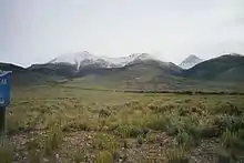
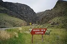
The Lost River Range, the state's highest mountains, are located in eastern Custer County. The highest is Borah Peak, the highest natural point in Idaho at 12,662 feet (3,859 m). On the western border of the county is Idaho's famous Sawtooth Range; the tallest is Thompson Peak in Custer County, above picturesque Redfish Lake. Twenty miles (32 km) east are the White Cloud Mountains, the tallest of which is Castle Peak at 11,815 feet (3,601 m).
The Salmon River and Big Lost River flow through Custer County.
Adjacent counties
- Lemhi County - north
- Butte County - east
- Blaine County - south
- Elmore County - southwest
- Boise County - southwest
- Valley County - west
National protected areas
Demographics
| Historical population | |||
|---|---|---|---|
| Census | Pop. | %± | |
| 1890 | 1,870 | — | |
| 1900 | 2,049 | 9.6% | |
| 1910 | 3,001 | 46.5% | |
| 1920 | 3,550 | 18.3% | |
| 1930 | 3,162 | −10.9% | |
| 1940 | 3,549 | 12.2% | |
| 1950 | 3,318 | −6.5% | |
| 1960 | 2,996 | −9.7% | |
| 1970 | 2,967 | −1.0% | |
| 1980 | 3,385 | 14.1% | |
| 1990 | 4,133 | 22.1% | |
| 2000 | 4,342 | 5.1% | |
| 2010 | 4,368 | 0.6% | |
| 2018 (est.) | 4,280 | [5] | −2.0% |
| U.S. Decennial Census[6] 1790-1960[7] 1900-1990[8] 1990-2000[9] 2010-2018[1] | |||
2000 census
As of the census[10] of 2000, there were 4,342 people, 1,770 households, and 1,196 families living in the county. The population density was 0.88 people per square mile (0.34/km2). There were 2,983 housing units at an average density of 0.60 per square mile (0.23/km2). The racial makeup of the county was 97.28% White, 0.55% Native American, 0.02% Asian, 0.02% Pacific Islander, 1.17% from other races, and 0.94% from two or more races. 4.21% of the population were Hispanic or Latino of any race. 18.6% were of English, 17.0% German, 10.9% Irish and 9.9% American ancestry.
There were 1,770 households, out of which 29.90% had children under the age of 18 living with them, 60.10% were married couples living together, 4.40% had a female householder with no husband present, and 32.40% were non-families. 27.70% of all households were made up of individuals, and 11.30% had someone living alone who was 65 years of age or older. The average household size was 2.41 and the average family size was 2.96.
In the county, the population was spread out, with 25.50% under the age of 18, 4.80% from 18 to 24, 25.90% from 25 to 44, 29.30% from 45 to 64, and 14.50% who were 65 years of age or older. The median age was 41 years. For every 100 females there were 104.50 males. For every 100 females age 18 and over, there were 106.80 males.
The median income for a household in the county was $32,174, and the median income for a family was $39,551. Males had a median income of $32,255 versus $21,463 for females. The per capita income for the county was $15,783. About 10.70% of families and 14.30% of the population were below the poverty line, including 16.70% of those under age 18 and 12.80% of those age 65 or over.
2010 census
As of the 2010 United States Census, there were 4,368 people, 1,936 households, and 1,244 families living in the county.[11] The population density was 0.9 inhabitants per square mile (0.35/km2). There were 3,103 housing units at an average density of 0.6 per square mile (0.23/km2).[12] The racial makeup of the county was 96.4% white, 0.6% American Indian, 0.2% black or African American, 0.2% Asian, 0.1% Pacific islander, 1.5% from other races, and 1.0% from two or more races. Those of Hispanic or Latino origin made up 4.0% of the population.[11] In terms of ancestry, 34.3% were English, 25.6% were German, 19.5% were Irish, and 2.8% were American.[13]
Of the 1,936 households, 24.2% had children under the age of 18 living with them, 55.7% were married couples living together, 4.8% had a female householder with no husband present, 35.7% were non-families, and 30.2% of all households were made up of individuals. The average household size was 2.25 and the average family size was 2.74. The median age was 48.0 years.[11]
The median income for a household in the county was $41,910 and the median income for a family was $56,710. Males had a median income of $42,865 versus $27,317 for females. The per capita income for the county was $22,625. About 10.1% of families and 13.8% of the population were below the poverty line, including 19.2% of those under age 18 and 13.2% of those age 65 or over.[14]
Politics
Custer County is overwhelmingly Republican. The last Democrat to carry the county was John F. Kennedy in 1960, since 1968 no Democrat has passed 37 percent of the county's vote, and the last to pass 28 percent was Michael Dukakis in 1988. However, unusually for so Republican a county, the westernmost precincts adjacent to Blaine County give Democratic majorities in most statewide elections. In the 2008 Presidential election, it supported Republican John McCain over Democrat Barack Obama by a margin of 71 percent to 25 percent. In 2012, the county gave Mitt Romney a first ballot victory in the Republican primary caucus[15] and subsequently voted 74.1 percent for him in the Presidential election.[16] In 2016, Donald Trump won the Republican primaries with 41.8 percent of support in the county although Ted Cruz won the state with 45.5 percent.[17]
| Year | Republican | Democratic | Third parties |
|---|---|---|---|
| 2016 | 73.6% 1,777 | 17.7% 427 | 8.7% 210 |
| 2012 | 74.1% 1,744 | 22.5% 530 | 3.4% 81 |
| 2008 | 72.0% 1,694 | 26.0% 611 | 2.0% 48 |
| 2004 | 74.7% 1,762 | 23.7% 559 | 1.6% 37 |
| 2000 | 77.0% 1,794 | 17.9% 416 | 5.2% 120 |
| 1996 | 53.9% 1,249 | 27.4% 635 | 18.7% 432 |
| 1992 | 38.3% 829 | 26.1% 564 | 35.6% 771 |
| 1988 | 66.1% 1,253 | 32.5% 616 | 1.4% 27 |
| 1984 | 77.1% 1,653 | 21.5% 461 | 1.4% 30 |
| 1980 | 73.5% 1,398 | 20.9% 398 | 5.6% 106 |
| 1976 | 60.3% 850 | 36.6% 516 | 3.1% 43 |
| 1972 | 69.1% 989 | 19.1% 274 | 11.8% 169 |
| 1968 | 50.0% 711 | 27.1% 385 | 23.0% 327 |
| 1964 | 50.2% 720 | 49.8% 714 | |
| 1960 | 43.7% 651 | 56.3% 838 | |
| 1956 | 60.3% 811 | 39.7% 533 | |
| 1952 | 69.7% 1,058 | 29.8% 452 | 0.5% 7 |
| 1948 | 48.7% 612 | 49.7% 625 | 1.6% 20 |
| 1944 | 48.0% 565 | 52.0% 613 | |
| 1940 | 45.8% 760 | 53.9% 894 | 0.3% 5 |
| 1936 | 37.3% 530 | 61.6% 875 | 1.1% 16 |
| 1932 | 33.8% 440 | 64.4% 839 | 1.8% 24 |
| 1928 | 55.3% 647 | 44.1% 516 | 0.7% 8 |
| 1924 | 46.0% 585 | 31.0% 394 | 23.0% 293 |
| 1920 | 67.2% 808 | 32.8% 394 | |
| 1916 | 32.2% 454 | 62.4% 879 | 5.4% 76 |
| 1912 | 27.4% 326 | 42.1% 501 | 30.5% 362 |
| 1908 | 43.1% 521 | 49.5% 598 | 7.4% 90 |
| 1904 | 51.3% 496 | 44.4% 429 | 4.3% 42 |
| 1900 | 30.7% 261 | 69.3% 590 |
References
- "State & County QuickFacts". United States Census Bureau. Archived from the original on July 9, 2011. Retrieved June 28, 2014.
- "Find a County". National Association of Counties. Archived from the original on May 31, 2011. Retrieved June 7, 2011.
- "Custer County, Idaho | we are what America used to be". www.co.custer.id.us. Retrieved April 4, 2018.
- "US Gazetteer files: 2010, 2000, and 1990". United States Census Bureau. February 12, 2011. Retrieved April 23, 2011.
- "Population and Housing Unit Estimates". Retrieved September 6, 2019.
- "U.S. Decennial Census". United States Census Bureau. Retrieved June 28, 2014.
- "Historical Census Browser". University of Virginia Library. Retrieved June 28, 2014.
- "Population of Counties by Decennial Census: 1900 to 1990". United States Census Bureau. Retrieved June 28, 2014.
- "Census 2000 PHC-T-4. Ranking Tables for Counties: 1990 and 2000" (PDF). United States Census Bureau. Retrieved June 28, 2014.
- "U.S. Census website". United States Census Bureau. Retrieved January 31, 2008.
- "DP-1 Profile of General Population and Housing Characteristics: 2010 Demographic Profile Data". United States Census Bureau. Archived from the original on February 13, 2020. Retrieved January 9, 2016.
- "Population, Housing Units, Area, and Density: 2010 - County". United States Census Bureau. Archived from the original on February 13, 2020. Retrieved January 9, 2016.
- "DP02 SELECTED SOCIAL CHARACTERISTICS IN THE UNITED STATES – 2006-2010 American Community Survey 5-Year Estimates". United States Census Bureau. Archived from the original on February 13, 2020. Retrieved January 9, 2016.
- "DP03 SELECTED ECONOMIC CHARACTERISTICS – 2006-2010 American Community Survey 5-Year Estimates". United States Census Bureau. Archived from the original on February 13, 2020. Retrieved January 9, 2016.
- "Idaho County Map". CNN.
- "2016 Presidential election results". The New York Times.
- "Idaho Presidential Primaries". Fox News.
- Leip, David. "Dave Leip's Atlas of U.S. Presidential Elections". uselectionatlas.org. Retrieved April 4, 2018.
External links
Further reading
Places adjacent to Custer County, Idaho | ||||||||||
|---|---|---|---|---|---|---|---|---|---|---|
| ||||||||||
Municipalities and communities of Custer County, Idaho, United States | ||
|---|---|---|
| Cities | Map of Idaho highlighting Custer County | |
| Unincorporated communities | ||
| Ghost towns | ||
| ||
Boise (capital) | ||
| Topics |
| |
| Society | ||
| Regions | ||
| Larger cities | ||
| Smaller cities | ||
| Counties |
| |
| Authority control |
|---|