Mount Crandell
Mount Crandell is a 2,381-metre (7,812-foot) mountain summit located in Waterton Lakes National Park, in the Canadian Rockies of Alberta, Canada. It is situated immediately north of the Waterton townsite. Its nearest higher peak is Bertha Peak, 2.94 km (1.83 mi) to the south-southwest.[5]
| Mount Crandell | |
|---|---|
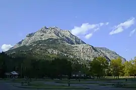 Mouint Crandell seen from Waterton Town Campground | |
| Highest point | |
| Elevation | 2,381 m (7,812 ft) [1] |
| Prominence | 781 m (2,562 ft) [1] |
| Parent peak | Mount Blakiston (2932 m) |
| Coordinates | 49°04′37″N 113°55′41″W [2] |
| Geography | |
 Mount Crandell Location of Mount Crandell in Alberta  Mount Crandell Mount Crandell (Canada) | |
| Location | Alberta, Canada |
| Parent range | Clark Range[3] Canadian Rockies |
| Topo map | NTS 82H04[2] |
| Geology | |
| Age of rock | Cambrian |
| Type of rock | sedimentary rock |
| Climbing | |
| Easiest route | Scrambling[4] |
History
Mount Crandell was named in 1914 after Edward H. Crandell who was one of Calgary's first oilmen.[1][6]
The mountain's name was made official in 1943 by the Geographical Names Board of Canada.[2]
Geology
Like other mountains in Waterton Lakes National Park, Mount Crandell is composed of sedimentary rock laid down during the Precambrian to Jurassic periods. Formed in shallow seas, this sedimentary rock was pushed east and over the top of younger Cretaceous period rock during the Laramide orogeny.[7]
Climate
Based on the Köppen climate classification, Mount Crandell is located in a subarctic climate with cold, snowy winters, and mild summers.[8] Temperatures can drop below −20 C with wind chill factors below −30 C. Precipitation runoff from Mount Crandell drains into Waterton Lake, thence Waterton River.
See also
References
- "Mount Crandell". Bivouac.com. Retrieved 2019-01-15.
- "Mount Crandell". Geographical Names Data Base. Natural Resources Canada. Retrieved 2019-01-15.
- Clark Range Peakbagger
- http://www.explor8ion.com/vern/scrambles/crandell/crandell.html
- https://www.peakbagger.com/peak.aspx?pid=4717
- Place-names of Alberta. Ottawa: Geographic Board of Canada. 1928. p. 39.
- Gadd, Ben (2008). "Geology of the Rocky Mountains and Columbias". Cite journal requires
|journal=(help) - Peel, M. C.; Finlayson, B. L. & McMahon, T. A. (2007). "Updated world map of the Köppen−Geiger climate classification". Hydrol. Earth Syst. Sci. 11: 1633–1644. ISSN 1027-5606.
External links
- Parks Canada web site: Waterton Lakes National Park