Mushroom Peak
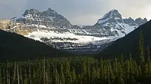
Mushroom Peak is a mountain located in the Sunwapta River valley of Alberta, Canada's Jasper National Park, lying just over a kilometre east of Diadem Peak. The mountain was named in 1947 by Noel E. Odell who made the first ascent (solo). Upon reaching the summit, he found that the dark limestone rocks there resembled mushrooms.[1] The mountain can be seen from the Icefields Parkway.
| Mushroom Peak | |
|---|---|
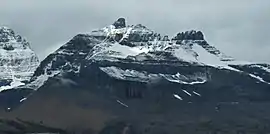 Mushroom Peak, south aspect, seen from Icefields Parkway | |
| Highest point | |
| Elevation | 3,210 m (10,530 ft) [1] |
| Prominence | 270 m (890 ft) [2] |
| Coordinates | 52°18′43″N 117°23′50″W [2] |
| Geography | |
 Mushroom Peak Location in Alberta | |
| Location | Alberta, Canada |
| Parent range | Winston Churchill Range |
| Topo map | NTS 83C/06 |
| Climbing | |
| First ascent | 1947 by Noel E. Odell |
| Easiest route | rock/snow climb |
Climate
Based on the Köppen climate classification, Mushroom Peak is located in a subarctic climate with cold, snowy winters, and mild summers.[3] Temperatures can drop below -20 °C with wind chill factors below -30 °C. Precipitation runoff from the mountain drains into the Sunwapta River which is a tributary of the Athabasca River.
Geology
Mushroom Peak is composed of sedimentary rock laid down during the Precambrian to Jurassic periods. Formed in shallow seas, this sedimentary rock was pushed east and over the top of younger rock during the Laramide orogeny.[4]
References
- "Mushroom Peak". PeakFinder.com. Retrieved 2007-08-31.
- "Mushroom Peak". Bivouac.com. Retrieved 2009-01-02.
- Peel, M. C.; Finlayson, B. L.; McMahon, T. A. (2007). "Updated world map of the Köppen−Geiger climate classification". Hydrol. Earth Syst. Sci. 11: 1633–1644. ISSN 1027-5606.
- Gadd, Ben (2008). "Geology of the Rocky Mountains and Columbias". Cite journal requires
|journal=(help)
External links
- National Park Service web site: Jasper National Park
- Mushroom Peak weather web site: Mountain Forecast
