Nalbari
Nalbari (Pron: nɔ:lˈbɑ:rɪ) is a town and a municipal board in Nalbari district in the Indian state of Assam. Nalbari town is also the headquarters of Nalbari District.
Nalbari
Nabadeep | |
|---|---|
Town | |
 | |
 Nalbari Location in Assam, India  Nalbari Nalbari (India) | |
| Coordinates: 26.445°N 91.440°E | |
| Country | |
| State | Assam |
| Region | Lower Assam |
| District | Nalbari |
| Government | |
| • Body | Nalbari Municipality Board |
| Elevation | 42 m (138 ft) |
| Population (2001) | |
| • Total | 27,389 |
| Languages | |
| • Official | Assamese |
| • Native | Kamrupi dialect of Assamese |
| Time zone | UTC+5:30 (IST) |
| PIN | 781335, 781369 |
| Telephone code | 03624 |
| ISO 3166 code | IN-AS |
| Vehicle registration | AS-14-XXXX |
| Website | www.nalbari.nic.in |
Etymology
The word Nalbari derived from Nal and Bari. Nal is variety of reed while Bari is enclosed ground with plantation.
History
The history of Nalbari dates back to many centuries B.C. The area also produced a special perfume among others. The Chandan and Aguru products were highly exported to faraway places including north India.[1]
Language
The native speech of Nalbari is Nalbariya dialect, a dialect of the Kamrupi group of Assamese language.[2]
Archaeology
The Nalbari area is important for archeological point, there are various discoveries of copper plate inscriptions of Kamrupi kings from Nalbari.[3]
Economy
In the early part of the twenties a railway station of the Assam-Bengal Railway Company had been established here. As the train started running through, certain traders and businessmen from outside the state came and interacted with the local people. Business transactions were started on the rail station road. The Nalbari M.E. School had been started in the meantime to the Gurdon School site, and it was upgraded into a High School named Gurdon High School in 1917. Both these two events attracted the people to throng to the area which had changed its shape and size. It became a strong business centre with great growth potentials in the whole of the north bank of the river.
Migration started in a significant way. Population increased, administrative offices were started gradually and in 1931, it assumed an urban look. In 1941, it was declared as one of the town in Kamrup district with a town committee with a population of 3578. In 1945, the Nalbari College was started in a temporary shed and in 1950 it was shifted to its present site which helped in the growth of the Bidyapur-Shantipur area of the town into a densely populated area. The establishment of the PWD offices on the Palla road, led to the growth of the Gopalbazar area.
In 1968, Nalbari was upgraded into a subdivision with headquarters at Nalbari and in 1984, it was made the district headquarters of Nalbari District, all of which led to the upsurge of development process with huge population migration, primarily of local people.[4]
Geography
Climate
Nalbari has subtropical climate, with chilly winters, hot summers and wet monsoons.
| Climate data for Nalbari | |||||||||||||
|---|---|---|---|---|---|---|---|---|---|---|---|---|---|
| Month | Jan | Feb | Mar | Apr | May | Jun | Jul | Aug | Sep | Oct | Nov | Dec | Year |
| Record high °C (°F) | 28.8 (83.8) |
32.2 (90.0) |
38.4 (101.1) |
39.0 (102.2) |
37.0 (98.6) |
38.3 (100.9) |
36.5 (97.7) |
36.2 (97.2) |
35.8 (96.4) |
34.3 (93.7) |
31.0 (87.8) |
28.1 (82.6) |
39.0 (102.2) |
| Average high °C (°F) | 23.6 (74.5) |
26.2 (79.2) |
30.0 (86.0) |
31.2 (88.2) |
31.2 (88.2) |
31.7 (89.1) |
31.9 (89.4) |
32.2 (90.0) |
31.7 (89.1) |
30.3 (86.5) |
27.6 (81.7) |
24.7 (76.5) |
29.4 (84.9) |
| Average low °C (°F) | 10.3 (50.5) |
12.0 (53.6) |
15.9 (60.6) |
20.0 (68.0) |
22.7 (72.9) |
24.9 (76.8) |
25.6 (78.1) |
25.6 (78.1) |
24.7 (76.5) |
21.9 (71.4) |
16.7 (62.1) |
11.8 (53.2) |
19.3 (66.8) |
| Record low °C (°F) | 4.7 (40.5) |
5.1 (41.2) |
8.3 (46.9) |
13.0 (55.4) |
16.2 (61.2) |
20.4 (68.7) |
21.4 (70.5) |
22.1 (71.8) |
19.7 (67.5) |
13.6 (56.5) |
10.3 (50.5) |
6.0 (42.8) |
4.7 (40.5) |
| Average rainfall mm (inches) | 11.9 (0.47) |
18.3 (0.72) |
55.8 (2.20) |
147.9 (5.82) |
244.2 (9.61) |
316.4 (12.46) |
345.4 (13.60) |
264.3 (10.41) |
185.9 (7.32) |
91.2 (3.59) |
18.7 (0.74) |
7.1 (0.28) |
1,717.7 (67.63) |
| Average rainy days | 1.8 | 2.9 | 5.8 | 13.1 | 17.0 | 19.6 | 22.3 | 18.5 | 15.2 | 7.4 | 2.8 | 1.3 | 127.7 |
| Average relative humidity (%) | 79 | 65 | 57 | 68 | 75 | 81 | 83 | 82 | 83 | 82 | 82 | 82 | 77 |
| Mean monthly sunshine hours | 226.3 | 214.7 | 220.1 | 201.0 | 192.2 | 132.0 | 124.0 | 161.2 | 138.0 | 204.6 | 231.0 | 232.5 | 2,277.6 |
| Source: World Meteorological Organization | |||||||||||||
Education
Educational opportunities in Nalbari are of high quality. It boasts of producing most number of toppers in School level. Nalbari is famous for Sanskrit education and known as "Nabadeep" for presence of various Sanskrit education institutions like Kamrup Sanskrit Sanjivani Sabha.
First School was set up in Nalbari in the year 1887, which later known as Nalbari Govt Gurdon H.S School. Nalbari College, Nalbari; Nalbari Sanskrit College, Nalbari; Nalbari Commerce College, Nalbari; MNC Balika College, Nalbari; Barbhag College, Kamarkuchi; Baska College, Mashalpur; Barkhetri College, Mukalmua; Tihu College, Tihu; Barama College, Barama; Kamrup College, Chamata; Dhamdhama Anchalik College, Dhamdhama; Gyanpeeth Mahavidyalaya; Nalbari Law College, Nalbari; Sankardev Academy, Nalbari, D.S.R.Academy, Nalbari, Spectrum Gurukul,Nalbari are some premier colleges of Nalbari. Along with 28 Higher Secondary Schools, 145 High Schools, and 276 ME and MV Schools, Nalbari have massive educational infrastructure.
"Kumar Bhaskar Varma Sanskrit and Ancient Studies University" named after glorious king of Kamarupa, Bhaskar Varman and "Planetarium and the Science Centre" at Sariahtali, added up to this existing system.[5]
Tourism
- Planetarium and Science Centre - The Planetarium and the Science Centre is located at Sariahtali. Its Planetarium dome organises regular shows. The centre has various corners dedicated to different Scientific phenomenon.
- Kamrup Sanskrit Sanjivani Sabha - The Kamrup Sanskrit Sanjivani Sabha was formed in 1930's to preserve ancient Sanskrit manuscripts. It library contains thousands of rare Sanskrit manuscripts.
- Billeshwar Temple - The temple is dedicated to God Krishna, is over 500 years old. It is believed that a Shivalinga was unearthed in this place and hence it is notable that a temple for Lord Krishna is constructed in this site. Legends state that a priest who lived here owned a cow, which regularly gave milk to virina, a grass type. The king of the state was intrigued about it and he ordered the place to be dug up to find a Shivalinga on the spot. Following the incident, a temple was constructed here but it was dedicated to Krishna. Ahom king and Lakshmi Singha rebuilt the temple, which faced the wrath of natural disaster.
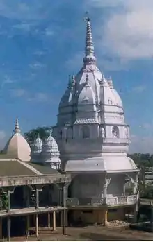
- Hari Mandir - The temple is major landmark of the town. Its history is correlated with the Ras Mahotsav being organized in Nalbari district since early twentieth century. The evolution of the Hari Mandir is been a saga of decades. The history of the Hari Mandir is connected to the Ras Puja of Nalbari. In the year 1931, under leading of the then Engineer Amar Kundu of Nalbari Public Works Department (PWD) and Veterinary Assistant Naren Basu and some of the local people including Gadamalla Barua, Dandiram Mahajan, Rabi Mahajan, Tanuram Das, Keertiram Thikadar, Padmapani Dutta and Bhairab Choudhury organized a meet at the official residence of engineer Kundu. Their issue of meet was about to organize Ras Puja at Nalbari. Though they weren't able to organize Ras Puja in the same year, but in the next year they were able to organize the Puja at the free space of the PWD Engineer Amar Kundu's official residence. In 1933, Ras Puja Committee was formed to organize the Puja. In that year, with the help of public donation, the Ras Puja was organized publicly at the Hatkhola (old) of Nalbari. At that time the Ras Puja was initiated religiously and was an occasion of 3 days. Soon after few years, the Ras Puja became popular and the organizers had to think about a new place for the Puja, as the need of wider place arose. The organizers and the local people searched for a permanent public plot to maintain the continuity of the Puja. Finally the permanent public plot found at the Dag No 584 of Nalbari town, with the grateful help of the then Sub-Deputy Collector Krishna Ram Medhi, and this is the plot till existing with current age. The plot was a private ownership property of which revenue was pending for many years. With a negotiation with the plot owner and Ras Puja comity, witnessed by the then Mouzadar Pratap Narayan Choudhury, the ownership of the plot was transferred to the Hari Mandir. In year 1939, the foundation of the Mandir (currently the old mandir) was imposed with the 4 wooden post of Shal donated by Priyanath Kabiraz of Alengidal. In year 1946 the Ras Puja was shifted from the Hathkhola (old) to the plot of the Hari Mandir. Late Damahuram Mahajan played the prime role in the construction of the Hari Mandir (old), which was completed in 1965. With help of his donation the Puja Mandap was constructed in 1968. With the change of ages, the popularity of Ras Puja increased year by year, so the growth of the Mandir too. Very sooner the Ras Puja festival turned from Utsava to Mahotsava with the continuation of public interest, co operation & donation. At the initial ages, the Ras Mahotsava was an occasion of 3 days, but in the decade of 1960 it became an occasion of 5 days, and then it became occasion of 7 days in the decade of 1970. Now the Ras Mahotsava is being organized as a festival of 11 to 15 days.
- Shripur Devalaya - The temple is believed to have been constructed by Sib Singha, an Ahom king. It is believed that a part of Goddess Parvati, when she was born on earth as Sati, fell here. Hence, the temple is dedicated to Goddess Parvati. The people celebrate Kali Puja and Durga Puja in this temple.
- Basudev Devalaya - It belongs to the period between 1718 and 1744 AD. It was constructed by Sib Singha, an Ahom king. King Sib Singha's brother Sib Singha made his contribution by donating 64 bighas of land to Basudeb Devalay. The legend centering on the construction of this temple is interesting. It is believed that a fisherman of this region was unable to remove his fishing net from a pond for seven days. On 7th day, it is said that Lord Basudeb appeared in the dream of a local person and asked to be released from the net. Following this, the person went over to the pond to find two large stones. Since efforts to remove the stones by King Sib Singha failed, a temple was built by him at the site.
- Buddhist temple - The Buddhist temple is located 30 km away from Nalbari town. The temple was constructed by Nepali people in the year 1965, it was initiated by Chhatra Singh. A new Gumba was constructed in the year 1971 by Chhatra Singh. The new Gumba earns a place among the biggest Gumba in Nalbari district. Devotees visit the place for annual Buddha Jayanti celebration.
- Kumar Bhaskar Varman Sanskrit and Ancient Studies University - The university is one of its kind in the entire region. The vision of university is to popularise studies in ancient history of Kamrup, which dates back to many centuries B.C. The university provides degrees in Sanskrit language. Its library contains numerous works on ancient history of Kamrup and Sanskrit language.
Transport
By road, Nalbari is accessible through National Highway 27 in north and connected to National Highway 427 in south. The Nalbari railway station is within town center, and Guwahati International Airport is at distance of 60 km.
Politics
Nalbari is part of Mangaldoi (Lok Sabha constituency).[6]
Notable people
- Abani Chakraborty, Poet
- Adya Sharma, Mobile theater pioneer
- Angoorlata Deka, Actress and Politician
- Bhumidhar Barman, Politician
- Chandra Mohan Patowary, Politician
- Mahadev Deka, Body Builder
- Trailokyanath Goswami, litterateur
- Seema Biswas, Bollywood Actress
See also
References
- Nath, Rajmohan (1948). The back-ground of Assamese culture. p. 172.
- Goswami, Upendranath (1970). A study on Kāmrūpī: a dialect of Assamese. Dept. of Historical Antiquarian Studies, Assam. p. 28.
The sub-dialectical varieties of Kamrupi may be grouped mainly into three divisions —western, central and southern. The variety spoken in the area comprising Barpeta, Sundardiya, Patbausi, Bhabani- pur etc. is western, that of Nalbari and its surrounding areas is central.
- Mukunda Madhava Sarma (1978),Inscriptions of Ancient Assam, p.193
- Ganguly, J. B. Urbanization and Development in North-east India: Trends and Policy Implications. Deep and Deep Publications. p. 191.
- "Planetarium and the Science Centre". newslivetv.com. Retrieved 23 May 2012.
- "List of Parliamentary & Assembly Constituencies" (PDF). Assam. Election Commission of India. Archived from the original (PDF) on 4 May 2006. Retrieved 6 October 2008.