Kokrajhar district
Kokrajhar district is an administrative district in Bodoland Territorial Region of Assam. It is predominantly inhabited by the Boro tribe. The district has its headquarters located at Kokrajhar Town and occupies an area of 3,169.22 km2 (1,223.64 sq mi). It has two civil sub-divisions namely Parbatjhora and Gossaigaon and five revenue circles namely Kokrajhar, Dotma, Bhaoraguri, Gossaigaon and Bagribari.
Kokrajhar district | |
|---|---|
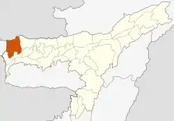 Map of Kokrajhar district in Assam | |
| Country | |
| State | |
| Territorial Region | |
| Headquarters | Kokrajhar |
| Area | |
| • Total | 3,169.22 km2 (1,223.64 sq mi) |
| Population (2011) | |
| • Total | 887,142 |
| • Density | 280/km2 (730/sq mi) |
| Time zone | UTC+05:30 (IST) |
| ISO 3166 code | IN-AS |
| Website | kokrajhar.gov.in |
History
Kokrajhar was a part the undivided Goalpara district. In 1957, under the administration of Bimala Prasad Chaliha as the Chief Minister of Assam, three sub-divisions were created one of which was Kokrajhar. This sub-division was made into a district on 1 July 1983.[1]
On 29 September 1989 Bongaigaon district was created from parts of Kokrajhar and Goalpara.[1]
Geography
Kokrajhar district occupies an area of 3,129 square kilometres (1,208 sq mi),[2] comparatively equivalent to Russia's Waigeo Island.[3] Kokrajhar district is located on the northern bank of the Brahmaputra river. It forms the gateway to the Seven Sister States. Kokrajhar shares its boundary with Bongaigaon (now known as Chirang), Dhubri, West Bengal, Barpeta and Bhutan. Part of the district is made up of Manas National Park.
Economy
In 2006 the Indian government named Kokrajhar one of the country's 250 most backward districts (out of a total of 640).[4] It is one of the eleven districts in Assam currently receiving funds from the Backward Regions Grant Fund Programme (BRGF).[4]
Divisions
There are four Assam Legislative Assembly constituencies in this district: Gossaigaon, Kokrajhar West, Kokrajhar East, and Sidli.[5] All but Gossaigaon are designated for scheduled tribes.[5] All four are in the Kokrajhar Lok Sabha constituency.[6]
Demographics
| Year | Pop. | ±% p.a. |
|---|---|---|
| 1901 | 79,378 | — |
| 1911 | 103,171 | +2.66% |
| 1921 | 130,947 | +2.41% |
| 1931 | 151,581 | +1.47% |
| 1941 | 174,060 | +1.39% |
| 1951 | 190,164 | +0.89% |
| 1961 | 270,930 | +3.60% |
| 1971 | 416,996 | +4.41% |
| 1991 | 744,609 | +2.94% |
| 2001 | 843,243 | +1.25% |
| 2011 | 887,142 | +0.51% |
| source:[8] | ||
According to the 2011 census Kokrajhar district has a population of 887,142,[9] roughly equal to the nation of Fiji.[10] This gives it a ranking of 467th in India (out of a total of 640).[9] The district has a population density of 280 inhabitants per square kilometre (730/sq mi).[9] Its population growth rate over the decade 2001-2011 was 5.19%.[9] Kokrajhar has a sex ratio of 958 females for every 1000 males,[9] and a literacy rate of 66.63%.[9]
The district is multi-ethnic, with no majority ethnic group but Bodo people form a plurality. Kokrajhar is known as a global center of Bodo culture and language and serves as the capital of Bodoland Territorial Council. Most of the indigenous communities of Kokrajhar are Hindu, with a small Christian minority. Almost all of the Bengalis are Hindu, while more than 90% of the Santhals are Christian.[11]
Flora and fauna
In 1990 Kokrajhar district became home to Manas National Park, which has an area of 500 km2 (193.1 sq mi).[12] It shares the park with four other districts.
Tourist attractions
Surrounded by stretches of lush green forests, booming with the various calls of its wild inhabitants, while the river Gourang gushes past it, Kokrajhar is indeed nature at its best
There is much to be explored in the wilderness of Kokrajhar. The Chakrashila Wildlife Sanctuary is the highlight of the city's tourism scene. Spread across a vast area, it is a treasure trove of wild flora and fauna. Many rare animals, including the golden langur, rhesus macaque, Indian pipistrelle, Chinese pangolin, Asiatic jackal, and Bengal fox can be spotted here. Bird watchers can delight in catching sight of several species such as hornbill, little cormorant, night heron, cotton teal, open billed stork, and many others. The Dheer Beel and Diplai Beel are the two lakes situated within the sanctuary and are worth visiting for their scenic appeal.
Along with abundant wildlife and natural surroundings, Kokrajhar also has some sightseeing locations. The Daimalu Park and Thandwai Brahma Memorial Park are among the popular sites in the city and are ideal for relaxing in the tranquil surroundings. The Mahamaya Dham of Parbatjhora is a site of religious importance visited by devotees. The marvellous architecture of Mahamaya Snanghat Mandir is sui-generis. The lofty Maa Kali statue of Pachis Haat Kali Mandir catches the attention of the passers-by.
Situated on the banks of the river Gourang, Kokrajhar is an ideal destination for thrill seekers, who can enjoy adventure sports such as river rafting, river camping, and canoeing. The surrounding forest also makes it a perfect location for a wildlife photography trip. Visit the local markets to buy souvenirs such as tribal handicrafts made of wood, bamboo, earthenware, clay and cotton toys, among others.
Saralpara near Bhutan border attracts many local tourists.
Notable people
- Bineshwar Brahma, poet and author
- Upendranath Brahma, Bodo leader
- Ranjit Shekhar Mooshahary, IPS officer, director general of National Security Guards and Border Security Force, former governor of Meghalaya.
- Kameshwar Brahma, writer, president of Bodo Sahitya Sabha and Padma Shri recipient
- Kalicharan Brahma , renowned social and religious reformer of Parbatjhora
References
- Law, Gwillim (25 September 2011). "Districts of India". Statoids. Retrieved 11 October 2011.
- Srivastava, Dayawanti et al. (ed.) (2010). "States and Union Territories: Assam: Government". India 2010: A Reference Annual (54th ed.). New Delhi, India: Additional Director General, Publications Division, Ministry of Information and Broadcasting (India), Government of India. p. 1116. ISBN 978-81-230-1617-7.CS1 maint: extra text: authors list (link)
- "Island Directory Tables: Islands by Land Area". United Nations Environment Program. 18 February 1998. Retrieved 11 October 2011.
Waigeo 3,154km2
- Ministry of Panchayati Raj (8 September 2009). "A Note on the Backward Regions Grant Fund Programme" (PDF). National Institute of Rural Development. Archived from the original (PDF) on 5 April 2012. Retrieved 27 September 2011.
- "List of Assembly Constituencies showing their Revenue & Election District wise break - up" (PDF). Chief Electoral Officer, Assam website. Archived from the original (PDF) on 22 March 2012. Retrieved 26 September 2011.
- "List of Assembly Constituencies showing their Parliamentary Constituencies wise break - up" (PDF). Chief Electoral Officer, Assam website. Archived from the original (PDF) on 22 March 2012. Retrieved 26 September 2011.
- District Report - KOKRAJHAR Archived 29 March 2017 at the Wayback Machine Ministry of Minority Affairs, Govt of India
- Decadal Variation In Population Since 1901
- "District Census 2011". Census2011.co.in. 2011. Retrieved 30 September 2011.
- US Directorate of Intelligence. "Country Comparison:Population". Retrieved 1 October 2011.
Fiji 883,125 July 2011 est.
- Census 2001
- Indian Ministry of Forests and Environment. "Protected areas: Assam". Archived from the original on 23 August 2011. Retrieved 25 September 2011.
External links
Places adjacent to Kokrajhar district | |
|---|---|
kokrajhar. In