Bongaigaon district
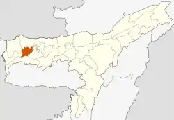
Bongaigaon district (Prpn:ˈbɒŋgaɪˌgãʊ) is an administrative district in the state of Assam in northeastern India. The district headquarters are located at Bongaigaon. The district occupies an area of 2,510 km2.
Bongaigaon district | |
|---|---|
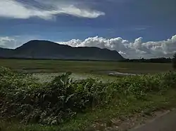 Bhumeshwar Hill | |
 | |
| Coordinates: 26.4667°N 90.5667°E | |
| Country | India |
| State | Assam |
| Division | Lower Assam |
| Headquarters | Bongaigaon |
| Area | |
| • Total | 976 km2 (377 sq mi) |
| Population (2011) | |
| • Total | 738,804 |
| • Density | 760/km2 (2,000/sq mi) |
| Time zone | UTC+05:30 (IST) |
| ISO 3166 code | IN-AS |
| Website | bongaigaon |
History
The district of Bongaigaon was created on 29 September 1989 from parts of Goalpara and Kokrajhar districts.[1] 2004 saw a loss of size when part of the district was split to make Chirang district.[1]
Geography
Bongaigaon district occupies an area of 1,724 square kilometres (666 sq mi),[2] comparatively equivalent to Réunion.[3] Bongaigaon district is surrounded by Barpeta in the east, the Brahmaputra in the south and Kokrajhar in the north and west corner and share international border with Bhutan in the north.
The places that are worth visiting in Bongaigaon are eco-park, Bagheswari temple, tea garden, and Suryapahar. The history of Bagheswari temple is such that once a priest saw in his dream that Maa Bagheswari asked him to go to a particular place where if he digs out he will find a sword that belonged to Maa Bagheswari. And the next morning when the priest went to dig in the place he saw in his dreams, he found the sword. After that day a temple was built over the place and there they worship the sword. There is no idol inside the temple.
Economy
In 2006 the Indian government named Bongaigaon one of the country's 250 most backward districts (out of a total of 640).[4] It is one of the eleven districts in Assam currently receiving funds from the Backward Regions Grant Fund Programme (BRGF).[4]
Divisions
The district has three subdivisions: Bongaigaon, Bijni, and North Salmara. In 2004, parts of the Bongaigaon district (mainly areas under Bijni subdivision) were given over to form the Chirang district, under the Bodoland Territorial Council (BTC), with its district headquarters at Kajalgaon.
There are four Assam Legislative Assembly constituencies in this district: Bongaigaon, Bijni, Abhayapuri North, and Abhayapuri South. The latter is designated for scheduled castes.[5] Bijni is in the Kokrajhar Lok Sabha constituency, whilst the other three are in the Barpeta Lok Sabha constituency.[6]
Demographics
According to the 2011 census, the total population of the district is 738,804, out of which 375,818 are males while 362,986 are females. The average sex ratio is 966. As per Census 2011 out of total population, 14.9% people lives in Urban areas while 85.1% lives in the Rural areas. The average literacy rate in urban areas is 87.4% while that in the rural areas is 66.4%. Also the Sex Ratio of Urban areas in Bongaigaon district is 960 while that of Rural areas is 967. The total literacy rate of Bongaigaon district is 69.74%. The male literacy rate is 63.09% and the female literacy rate is 54.26% in Bongaigaon district.[7]
Religion
The district religious composition are as follows: Hindu 359,145, Muslim 371,033, Christian 5,924, Sikh 384, Buddhist 236, Jain 871 as per 2011 census report.
References
- Law, Gwillim (25 September 2011). "Districts of India". Statoids. Retrieved 11 October 2011.
- Srivastava, Dayawanti et al. (ed.) (2010). "States and Union Territories: Assam: Government". India 2010: A Reference Annual (54th ed.). New Delhi, India: Additional Director General, Publications Division, Ministry of Information and Broadcasting (India), Government of India. p. 1116. ISBN 978-81-230-1617-7.CS1 maint: extra text: authors list (link)
- "Island Directory Tables: Islands by Land Area". United Nations Environment Program. 18 February 1998. Retrieved 11 October 2011.
Réunion 2,535km2
- Ministry of Panchayati Raj (8 September 2009). "A Note on the Backward Regions Grant Fund Programme" (PDF). National Institute of Rural Development. Archived from the original (PDF) on 5 April 2012. Retrieved 27 September 2011.
- "List of Assembly Constituencies showing their Revenue & Election District wise break – up" (PDF). Chief Electoral Officer, Assam website. Archived from the original (PDF) on 22 March 2012. Retrieved 26 September 2011.
- "List of Assembly Constituencies showing their Parliamentary Constituencies wise break – up" (PDF). Chief Electoral Officer, Assam website. Archived from the original (PDF) on 22 March 2012. Retrieved 26 September 2011.
- "District Census Hand Book". censusindia.gov.in.
- "C-16 Population By Mother Tongue - Bongaigaon". censusindia.gov.in. Retrieved 16 August 2020.
External links
Places adjacent to Bongaigaon district | ||||||||||
|---|---|---|---|---|---|---|---|---|---|---|
| ||||||||||