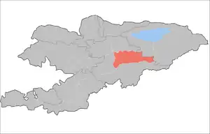
Naryn District
Naryn District' (formerly Tian'-Shan' District) is a raion of Naryn Region in central-southern Kyrgyzstan. The capital lies at Naryn.[2] Naryn District was established in its borders in 1930. It borders with At-Bashy District to the south, Ak-Talaa District to the west, Kochkor District to the north, Tong District to the north-east, Jeti-Oguz District to the east, and Song Köl to the north-west. Its area is 10,502 square kilometres (4,055 sq mi), and its resident population was 44,080 in 2009.[1]
Naryn District | |
|---|---|
 Countryside in Naryn District near Naryn | |
 | |
| Country | Kyrgyzstan |
| Region | Naryn Region |
| Area | |
| • Total | 4,055 sq mi (10,502 km2) |
| Population (2009)[1] | |
| • Total | 44,080 |
| • Density | 11/sq mi (4.2/km2) |
| Time zone | UTC+5 (GMT +5) |
The district is characterized by the scenic Tian Shan Mountains, alpine pastures and Son-Kul lake which during summer months attracts large herds of sheep and horses with their herders and their yurts.
Economy
The economy of Naryn oblast is dominated by animal herding (sheep, horses, yaks), with wool and meat as the main products. Mining of various minerals developed during the Soviet era has largely been abandoned as uneconomical. Today the area is considered to be the poorest region in the country.
Demographics
| Year | Pop. | ±% |
|---|---|---|
| 1970 | 30,487 | — |
| 1979 | 34,089 | +11.8% |
| 1989 | 36,863 | +8.1% |
| 1999 | 40,628 | +10.2% |
| 2009 | 44,080 | +8.5% |
| Note: enumerated de facto population; Source:[1] | ||
Rural communities and villages
In total, Naryn District includes 39 settlements in 15 rural communities (aiyl okmotus). The rural communities and settlements in the Naryn District are:[3][4]
- Ak-Kuduk aiyl okmotu (3: center - village: Segizinchi Mart; and also villages Ak-Kuduk and Shoro)
- Debelyuu aiyl okmotu (3: center - village: Debelyuu; and also villages Alysh and Kenesh)
- Jan-Bulak aiyl okmotu (1: center - village: Jan-Bulak)
- Jergetal aiyl okmotu (3: center - village: Jergetal; and also villages Jalgyz-Terek and Kyzyl-Jyldyz)
- Kara-Kudjur aiyl okmotu (2: center - village: Lakol; and also village Jer-Kökchü)
- Kazan-Kuygan aiyl okmotu (2: center - village: Kazan-Kuygan; and also village Kara-Unkyur)
- Emgekchil aiyl okmotu (1: center - village: Emgekchil)
- Min-Bulak aiyl okmotu (3: center - village: Kuybysheva; and also villages Min-Bulak and Ornok)
- On-Archa aiyl okmotu (2: center - village: Echki-Bashy; and also village Ottuk)
- Ortok aiyl okmotu (4: center - village: Tash-Bashat, and also villages Kaiyndy, Oryuk-Tam and Eki-Naryn)
- Uchkun aiyl okmotu (2: center - village: Kulanak; and also village Uchkun)
- Chet-Nura aiyl okmotu (8: center - village: Orto-Nura; and also villages Ak-Bulun, Ak-Kyya, Iyri-Suu, Orto-Saz, Oryuk-Tam, Chet-Nura and Tosh-Bulak)
- Emgek-Talaa aiyl okmotu (3: center - village: Ak-Talaa; and also villages Tegerek and Emgek-Talaa)
- Sary-Oy aiyl okmotu (1: center - village: Jylan-Aryk)
- Dostuk aiyl okmotu (1: center - village: Dostuk)
References
- "2009 population census of the Kyrgyz Republic: Naryn Region" (PDF). Archived from the original (PDF) on 25 October 2012. Retrieved 2016-06-15.
- Enrin.grida.no
- List of rural communities of Kyrgyzstan Archived 2010-02-09 at the Wayback Machine
- 2012 Law on the transformation of individual urban settlements of the Kyrgyz Republic and relating them to the category of village or city
| North Kyrgyzstan |
|  Raions of Kyrgyzstan | ||||||||||
|---|---|---|---|---|---|---|---|---|---|---|---|---|
| South Kyrgyzstan |
| |||||||||||
