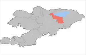
Tong District
Tong is a raion (district) of Issyk-Kul Region in north-eastern Kyrgyzstan. The capital lies at Bokonbayevo.[1] Its area is 7,230 square kilometres (2,790 sq mi), and its resident population was 49,130 in 2009.[2] Tong District borders Issyk Kul District to the north-west, Jeti-Oguz District to the south and south-east, Kochkor District to the south-west, Naryn District to the south, Kemin District to the north-west, and Issyk Kul - to the north.
Tong
Тоң району | |
|---|---|
 Coat of arms | |
 | |
| Country | Kyrgyzstan |
| Region | Issyk-Kul Region |
| Area | |
| • Total | 7,230 km2 (2,790 sq mi) |
| Population (2009) | |
| • Total | 49,130 |
| • Density | 6.8/km2 (18/sq mi) |
| Time zone | UTC+5 (GMT +5) |
Populated places
In total, Tong District includes 30 villages located in nine rural communities (aiyl okmotus). Each rural community can consist of one or several villages. The rural communities and settlements in the Tong District are:[3][4]
- Kaji-Say aiyl okmotu (1: center - village: Kadji Say)
- Ak-Terek aiyl okmotu (6: center - village: Kara-Koo; and also villages Ala-Bash, Bar-Bulak, Döng-Talaa, Kalkagar and Kyzyl-Tuu)
- Kel-Ter aiyl okmotu (3: center - village: Toguz-Bulak; and also villages Kel-Ter and Kongur-Ölöng)
- Kek-Moynok aiyl okmotu (3: center - village: Akulen; and also villages Kök-Moynok-1 and Kök-Moynok-2 )
- Eshperovo aiyl okmotu (4: center - village: Eshperovo; and also villages Ak-Say, Jer-Üy and Kok-Say)
- Kyun-Chygysh aiyl okmotu (2: center - village: Bokonbayevo; and also village Archaly)
- Tong aiyl okmotu (3: center - village: Ton; and also villages Kadji-Saz and Ak-Say)
- Tortkël' aiyl okmotu (3: center - village: Tört-Kül, and also villages Temir-Kanat and Tuura-Suu)
- Ulakol aiyl okmotu (5: center - village: Ottuk; and also villages Kara-Talaa, Kara-Shaar, Tuura-Suu and Shor-Bulak)
References
- Enrin.grida.no
- "2009 population census of the Kyrgyz Republic: Issyk-Kul Region" (PDF). Archived from the original (PDF) on 10 August 2011. Retrieved 2011-08-10.
- List of rural communities of Kyrgyzstan Archived 2010-02-09 at the Wayback Machine
- 2012 Law on the transformation of individual urban settlements of the Kyrgyz Republic and relating them to the category of village or city
| North Kyrgyzstan |
|  Raions of Kyrgyzstan | ||||||||||
|---|---|---|---|---|---|---|---|---|---|---|---|---|
| South Kyrgyzstan |
| |||||||||||
This article is issued from Wikipedia. The text is licensed under Creative Commons - Attribution - Sharealike. Additional terms may apply for the media files.