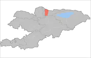
Ysyk-Ata District
Ysyk-Ata District (Russian: Ысык–Атинский район) is one of the eight districts of the Chuy Region in northern Kyrgyzstan with an area of 2,415 square kilometres (932 sq mi). According to 2009 Census, the district's resident population was 132,759 in 2009,[2] and estimated as 153,083 in 2020.[1] The administrative center of the district is the city of Kant (population 21,589 in 2009), and the district itself was known as Kant District in the past. The district is located on the southern side of the Chui River, about halfway between the national capital Bishkek and the former provincial capital Tokmok.
Ysyk-Ata | |
|---|---|
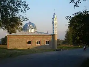 The new mosque in Pervomayskoe village | |
 | |
| Country | Kyrgyzstan |
| Region | Chuy Region |
| Area | |
| • Total | 2,415 km2 (932 sq mi) |
| Population (2020)[1] | |
| • Total | 153,083 |
| • Density | 63/km2 (160/sq mi) |
| Time zone | UTC+5 (GMT +5) |
Air force base and school
In 1941, a Soviet Air Force base and pilot training school were set up in the district. During World War II, 1507 military pilots were trained there. Since 1956, the school trained foreign pilots; among its graduates were both the ex-Egyptian president Hosni Mubarak and the late Syrian president Hafez Assad.
In 1992, the air base was transferred to Kyrgyzstan authorities; since 2003 it hosts Russian Air Force units. [3]
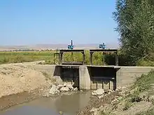
Water erosion
The district authorities, as well as the residents of the riverside village of Milianfan (Russian: Милянфан), are concerned with the River Chui gradually washing away the district's land, as it shifts its course to the south and erodes its left (southern) bank.[4]
Demographics
As of 2009, Ysyk-Ata District included 1 town, and 58 villages in 18 rural communities (aiyl okmotus).[5] Its de facto population, according to the Population and Housing Census of 2009, was 131,503, and de jure population 132,759. Some 21,762 people live in urban areas, and 109,741 in rural ones.
| Year | Pop. | ±% |
|---|---|---|
| 1970 | 99,172 | — |
| 1979 | 109,351 | +10.3% |
| 1989 | 128,371 | +17.4% |
| 1999 | 125,116 | −2.5% |
| 2009 | 131,503 | +5.1% |
| Note: enumerated de facto population; Source:[2] | ||
Ethnic composition
According to the 2009 Census, the ethnic composition of Ysyk-Ata District (de jure population) was:[2]
| Ethnic group | Population | Proportion of Kemin District population |
|---|---|---|
| Kyrgyzs | 62,620 | 47.2% |
| Russians | 28,000 | 21.1% |
| Dungans | 19,223 | 14.5% |
| Turks | 4,699 | 3.5% |
| Uygurs | 4,091 | 3.1% |
| Azerbaijanis | 3,486 | 2.6% |
| Germans | 1,524 | 1.1% |
| Ukrainians | 1,343 | 1.0% |
| Kazakhs | 1,317 | 1.0% |
| Tatars | 1,078 | 0.8% |
| Balkars | 611 | 0.5% |
| Koreans | 588 | 0.4% |
| Tadjiks | 383 | 0.3% |
| Kurds | 349 | 0.3% |
| Karachays | 182 | 0.1% |
| Bulgars | 108 | 0.1% |
| other groups | 950 | 0.7% |
Populated places
In total, Ysyk-Ata District includes 1 town and 56 settlements in 18 rural communities (aiyl okmotus). Each rural community can consist of one or several villages. The rural communities and settlements in Ysyk-Ata District are:[6]
- city Kant
- Ak-Kuduk aiyl okmotu (5: center - village: Kirovskoye; and also villages Ak-Kuduk, Kotovskoye, Pervomayskoye and Khun Chi (partly))
- Birdik aiyl okmotu (2: center - village: Birdik; and also village Khun Chi (partly))
- Ivanovka aiyl okmotu (1: center - village Ivanovka)
- Jeek aiyl okmotu (3: center - village: Dmitriyevka; and also villages Imeni Gagarina and Jeek)
- Internatsionalnyi aiyl okmotu (2: center - village: Internatsionalnoye; and also village Jar-Bashy)
- Keng-Bulun aiyl okmotu (4: center - village: Keng-Bulun; and also villages Gidrostroitel, Druzhba and Cholpon)
- Kochkorbaev aiyl okmotu (3: center - village: Kengesh; and also villages Budennovka and Dokturbek Kurmanaliev)
- Krasnorechenskiy aiyl okmotu (1: center - village: Krasnaya Rechka)
- Logvinenko aiyl okmotu (2: center - village: Novopokrovka (partly); and also village Chong-Daly)
- Lyuksemburg aiyl okmotu (2: center - village: Lyuksemburg; and also village Kirshelk)
- Milyanfan aiyl okmotu (1: center - village: Milyanfan)
- Novopokrovka aiyl okmotu (3: center - village: Novopokrovka (partly); and also villages Leninskoye and Sary-Jon)
- Nurmanbet aiyl okmotu (3: center - village: Nurmanbet; and also villages Pervomayskoye and Imeni Aliaskara Toktonalieva)
- Syn-Tash aiyl okmotu (8: center - village: Imeni Telmana; and also villages Ak-Say, Jetigen, Kyzyl-Aryk, Otogon, Rot-Front, Sovetskoye and Syn-Tash)
- Tuz aiyl okmotu (4: center - village: Tuz; and also villages Dayyrbek, Jayalma and Nizhnyaya Serafimovka)
- Uzun-Kyr aiyl okmotu (3: center - village: Jer-Kazar; and also villages Druzhba and Nizhniy Norus)
- Yurevka aiyl okmotu (2: center - village: Yuryevka; and also village Ysyk-Ata)
- Ysyk-Ata aiyl okmotu (9: center - village: Almaluu; and also villages Gornaya Serafimovka, Jogorku-Ichke-Suu, Ichke-Suu, Karagay-Bulak, Norus, Tash-Bashat, Toguz-Bulak and Üch-Emchek)
Sources
- Ysyk-Ata District data at the provincial administration web site. (in Russian)
- Population of regions,districts, towns, urban-type settlements, rural communities and villages of Kyrgyz Republic (National Statistical Committee estimate as of beginning of 2020) Численность населения областей, районов, городов, поселков городского типа,айылных аймаков и сел Кыргызской Республики (оценка НСК на начало 2020г)
- 2009 population census of the Kyrgyz Republic: Chuy Region at the Wayback Machine (archived 2011-08-10)
- Санкт-Петербург взял шефство над российской авиационной базой в городе Кант (Киргизская Республика)
- Ползущая Чу. Территория Кыргызстана уменьшается с каждым годом ("The creeping Chui. The land of Kyrgyzstan shrinks every year") Вечерний Бишкек (Vecherniy Bishkek), No. 247, 2004-Dec-31.
- List of Rural Communities of Kyrgyzstan
- "Archived copy". Archived from the original on 2010-02-09. Retrieved 2010-03-14.CS1 maint: archived copy as title (link)
| North Kyrgyzstan |
|  Raions of Kyrgyzstan | ||||||||||
|---|---|---|---|---|---|---|---|---|---|---|---|---|
| South Kyrgyzstan |
| |||||||||||
