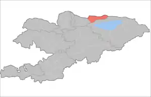
Kemin District
Kemin is the northeast panhandle raion (district) of Chuy Region in northern Kyrgyzstan. Its area is 3,533 square kilometres (1,364 sq mi), making it the largest district of Chuy Region, and its resident population was 44,118 in 2009.[1] Its administrative headquarters is at Kemin.[2] The district is located in the Chong-Kemin Valley, the Kichi-Kemin Valley and the eastern part of the Chuy Valley. It borders with Kazakhstan in the north, Chuy District in the west, and Issyk-Kul Province in the south and east.
Kemin | |
|---|---|
| Кемин району | |
 | |
| Country | Kyrgyzstan |
| Region | Chuy Region |
| Kemin District | 1936 |
| Capital | Kemin |
| Area | |
| • Total | 3,533 km2 (1,364 sq mi) |
| Population (2009)[1] | |
| • Total | 44,118 |
| • Density | 12/km2 (32/sq mi) |
| Time zone | UTC+5 (GMT +5) |
Topography
The western part of the district is flat with altitudes 1000–1600 msl, and the eastern part is mountainous.
Climate
The climate is sharply continental with cold winters and cool summers; January temperatures averaging −5 °C to −10 °C, July +17 °C to +18 °C. Average precipitation is from 200 mm in flatlands, and up to 600–700 mm in mountains.[3]
Hydrology
Large rivers in the district include Chu River, Chong-Kemin River, Kichi-Kemin River and others. There are also several small lakes: Chong-Kelter, Chelek and Kosh-Kel
Demographics
The population of Kemin District, according to the Population and Housing Census of 2009, was 44,118 which is second lowest among districts of the Chuy Region. Average density is 12 people per square kilometer. Some 36% of population lives in urban areas, and 64% in rural ones.[3]
| Year | Pop. | ±% |
|---|---|---|
| 1970 | 53,370 | — |
| 1979 | 57,068 | +6.9% |
| 1989 | 63,156 | +10.7% |
| 1999 | 52,722 | −16.5% |
| 2009 | 44,118 | −16.3% |
| Note: enumerated de facto population; Source:[1] | ||
Ethnic composition
According to the 2009 Census, the ethnic composition (de jure population) of the Kemin District was:[1]
| Ethnic group | Population | Proportion of Kemin District population |
|---|---|---|
| Kyrgyzs | 37,724 | 85.5% |
| Russians | 4,785 | 10.8% |
| Kazakhs | 550 | 1.2% |
| Dungans | 170 | 0.4% |
| Ukrainians | 170 | 0.4% |
| Tatars | 157 | 0.4% |
| Uzbeks | 133 | 0.3% |
| other groups | 429 | 1% |
Populated places
In total, Kemin District include 2 towns, 1 urban-type settlement and 34 settlements in 11 rural communities (aiyl okmotus). Each rural community can consist of one or several villages. The towns, urban-type settlements, rural communities and villages in the Kemin District are:[4][5]
- town Orlovka
- town Kemin
- urban-type settlement Bordunskiy
- Ak-Tüz aiyl okmotu (1: center - village: Ak-Tüz)
- Almaluu aiyl okmotu (3: center - village: Kyzyl-Suu; and also villages Almaluu and Bordu)
- Boroldoy aiyl okmotu (1: center - village: Boroldoy)
- Chong-Kemin aiyl okmotu (5: center - village: Shabdan; and also villages Kalmak-Ashuu, Kyzyl-Bayrak, Tar-Suu and Tört-Kül)
- Chym-Korgon aiyl okmotu (3: center - village: Chym-Korgon; and also villages Novomikhaylovka and Samansur)
- Duisheev aiyl okmotu (1: center - village: Kichi-Kemin)
- Ilich aiyl okmotu (3: center - village: Ilyich; and also villages Jangy-Jol and Sovetskoye)
- Jangy-Alysh aiyl okmotu (1: center - village: Jangy-Alysh)
- Kara-Bulak aiyl okmotu (4: center - village: Kara-Bulak; and also villages Beysheke, Altymysh and Chüy)
- Kok-Oyrok aiyl okmotu (3: center - village: Kayyngdy; and also villages Korool-Döbö and Tegirmenti)
- Kyzyl-Oktyabr aiyl okmotu (9: center - village: Kyzyl-Oktyabr; and also villages Ak-Beket, Jel-Aryk, Dorozhnoye, Kashkeleng, Kyz-Kyya, Sasyk-Bulak, Udarnik and Cholok)
References
- "2009 population census of the Kyrgyz Republic: Chuy Region" (PDF). Archived from the original (PDF) on 10 August 2011. Retrieved 2010-03-12.
- Enrin.grida.no Archived 2009-08-02 at the Wayback Machine
- "Web-page of Kemin District at Chuy Region web-site (in Russian)". Archived from the original on 2011-07-22. Retrieved 2010-01-12.
- List of Rural Communities of Kyrgyzstan Archived 2010-02-09 at the Wayback Machine
- 2012 Law on the transformation of individual urban settlements of the Kyrgyz Republic and relating them to the category of village or city
| North Kyrgyzstan |
|  Raions of Kyrgyzstan | ||||||||||
|---|---|---|---|---|---|---|---|---|---|---|---|---|
| South Kyrgyzstan |
| |||||||||||
