National Register of Historic Places listings in Buffalo County, South Dakota
This is a list of the National Register of Historic Places listings in Buffalo County, South Dakota.
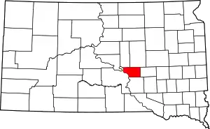
Location of Buffalo County in South Dakota
This is intended to be a complete list of the properties and districts on the National Register of Historic Places in Buffalo County, South Dakota, United States. The locations of National Register properties and districts for which the latitude and longitude coordinates are included below, may be seen in a map.[1]
There are 7 properties and districts listed on the National Register in the county, including 2 National Historic Landmarks. Another property was once listed but has been removed.
- This National Park Service list is complete through NPS recent listings posted January 29, 2021.[2]
Current listings
| [3] | Name on the Register[4] | Image | Date listed[5] | Location | City or town | Description |
|---|---|---|---|---|---|---|
| 1 | Bank of Buffalo County | February 12, 1999 (#99000206) |
Main St. 44°01′59″N 98°59′11″W |
Gann Valley | ||
| 2 | Crow Creek Site | 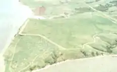 Crow Creek Site |
October 15, 1966 (#66000710) |
Eastern bank of the Missouri River, north of Chamberlain[6] 43°58′36″N 99°19′48″W |
Chamberlain | |
| 3 | Duncan Church | February 12, 1999 (#99000207) |
Southwest of Crow Creek, 2 miles south of the county line 44°10′50″N 99°04′09″W |
Gann Valley | ||
| 4 | Fort Thompson Archeological District | August 14, 1986 (#86002738) |
Address Restricted |
Fort Thompson | ||
| 5 | Fort Thompson Mounds | 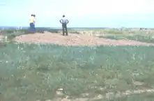 Fort Thompson Mounds |
October 15, 1966 (#66000711) |
Southeast of Fort Thompson at the top of the ridgeline over the Missouri River[7] 44°02′00″N 99°22′40″W |
Fort Thompson | |
| 6 | Long View Stock Farm | August 24, 2018 (#100002808) |
22182 361st Ave. 44°01′31″N 98°58′00″W |
Gann Valley vicinity | ||
| 7 | Talking Crow Archeological Site |  Talking Crow Archeological Site |
June 2, 2003 (#03000505) |
Right bank of Campbell Creek along Highway 47[8] 44°04′37″N 99°22′54″W |
Fort Thompson |
Former listing
| [3] | Name on the Register | Image | Date listed | Date removed | Location | City or town | Summary |
|---|---|---|---|---|---|---|---|
| 1 | Old Buffalo County Courthouse and Jail House | June 27, 2002 (#02000707) | March 26, 2008 | 100 Main Street |
Gann Valley |
See also
| Wikimedia Commons has media related to National Register of Historic Places in Buffalo County, South Dakota. |
References
- The latitude and longitude information provided in this table was derived originally from the National Register Information System, which has been found to be fairly accurate for about 99% of listings. Some locations in this table may have been corrected to current GPS standards.
- "National Register of Historic Places: Weekly List Actions". National Park Service, United States Department of the Interior. Retrieved on January 29, 2021.
- Numbers represent an alphabetical ordering by significant words. Various colorings, defined here, differentiate National Historic Landmarks and historic districts from other NRHP buildings, structures, sites or objects.
- "National Register Information System". National Register of Historic Places. National Park Service. April 24, 2008.
- The eight-digit number below each date is the number assigned to each location in the National Register Information System database, which can be viewed by clicking the number.
- Location derived from its NHL profile Archived 2009-06-14 at the Wayback Machine and from the GNIS feature record for the mouth of Crow Creek; the NRIS lists the site as "Address Restricted"
- Neuman, Robert W. "Projectile Points from Preceramic Occupations Near Fort Thompson, South Dakota: A Preliminary Report". Plains Anthropologist 9.25 (1964): 173-189: 176.
- Smith, Carlyle S. "Pottery Types from the Talking Crow Site, Fort Randall Reservoir, South Dakota". Plains Archeological Conference News Letter 4.3 (1951): 30-41: 32.
| Topics | |
|---|---|
| Lists by state |
|
| Lists by insular areas | |
| Lists by associated state | |
| Other areas | |
| Related | |
| |
Municipalities and communities of Buffalo County, South Dakota, United States | ||
|---|---|---|
| CDP | | |
| Unincorporated community | ||
| Township |
| |
| Unorganized territories |
| |
| Indian reservation | ||
| Footnotes | ‡This populated place also has portions in an adjacent county or counties | |
| ||
This article is issued from Wikipedia. The text is licensed under Creative Commons - Attribution - Sharealike. Additional terms may apply for the media files.