National Register of Historic Places listings in Manistee County, Michigan
This is a list of the National Register of Historic Places listings in Manistee County, Michigan.
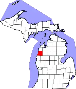
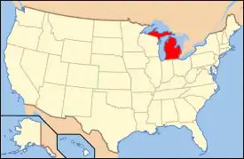
Location of Manistee County in Michigan
This is intended to be a complete list of the properties and districts on the National Register of Historic Places in Manistee County, Michigan, United States. Latitude and longitude coordinates are provided for many National Register properties and districts; these locations may be seen together in a map.[1]
There are 18 properties and districts listed on the National Register in the county, including 1 National Historic Landmark.
- This National Park Service list is complete through NPS recent listings posted February 5, 2021.[2]
Current listings
| [3] | Name on the Register[4] | Image | Date listed[5] | Location | City or town | Description |
|---|---|---|---|---|---|---|
| 1 | Simeon Babcock House | 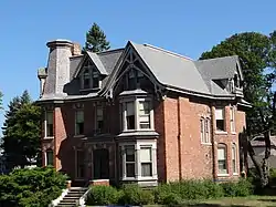 Simeon Babcock House |
November 30, 1999 (#99001455) |
420 Third St. 44°14′40″N 86°19′33″W |
Manistee | |
| 2 | Camp Tosebo | 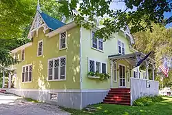 Camp Tosebo |
December 21, 2000 (#00000644) |
7228 Miller Rd., Onekama Township 44°20′58″N 86°14′32″W |
Red Park vicinity | |
| 3 | City of Milwaukee | 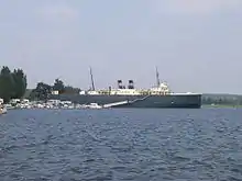 City of Milwaukee |
December 14, 1990 (#90002221) |
99 Arthur Street 44°15′34″N 86°18′57″W |
Manistee | When listed on the National Register in 1990, the ship was located in Elberta, Michigan (Benzie County), but was moved to Manistee in 2000.[6] It is located at 99 Arthur Street.[7] |
| 4 | First Congregational Church | 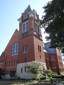 First Congregational Church |
June 25, 1974 (#74000995) |
412 S. 4th St. 44°14′41″N 86°19′24″W |
Manistee | |
| 5 | Guardian Angels Church | 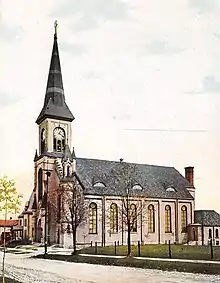 Guardian Angels Church |
April 14, 2020 (#100005180) |
371-375 Fifth St. 44°14′31″N 86°19′20″W |
Manistee | |
| 6 | John J. Makinen Bottle House |  John J. Makinen Bottle House |
July 9, 1987 (#87000423) |
14551 Wuoksi Ave. 44°22′23″N 86°00′33″W |
Kaleva | |
| 7 | Manistee Central Business District | 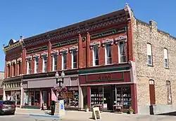 Manistee Central Business District |
May 7, 1982 (#82002851) |
Roughly bonded by Maple, Washington, Water and River Sts. 44°14′54″N 86°19′26″W |
Manistee | |
| 8 | Manistee County Courthouse Fountain | 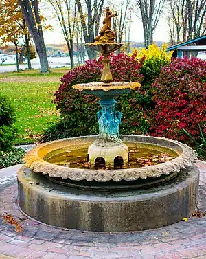 Manistee County Courthouse Fountain |
February 8, 1988 (#88000065) |
Onekama Village Park 44°21′48″N 86°12′23″W |
Onekama | |
| 9 | Manistee Harbor, South Breakwater | 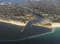 Manistee Harbor, South Breakwater |
October 20, 1995 (#95001162) |
Mouth of the Manistee R., at Lake Michigan 44°15′05″N 86°21′00″W |
Manistee | |
| 10 | Manistee Iron Works Machine Shop | Manistee Iron Works Machine Shop |
July 19, 2010 (#10000477) |
254 River St. 44°15′00″N 86°18′49″W |
Manistee | |
| 11 | Manistee North Pier | 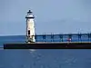 Manistee North Pier |
May 17, 1990 (#90000718) |
W end of Fifth Ave. 44°15′04″N 86°20′42″W |
Manistee | |
| 12 | Orchard Beach State Park | 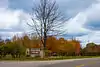 Orchard Beach State Park |
December 8, 2009 (#09001064) |
2064 N. Lakeshore Road 44°18′11″N 86°18′06″W |
Manistee | |
| 13 | Our Saviour's Evangelical Lutheran Church | 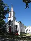 Our Saviour's Evangelical Lutheran Church |
August 21, 1972 (#72000639) |
300 Walnut St. 44°14′37″N 86°19′15″W |
Manistee | |
| 14 | Portage Point Inn Complex | 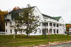 Portage Point Inn Complex |
October 8, 1985 (#85003001) |
8513 S. Portage Point Dr. 44°22′03″N 86°15′32″W |
Onekama | |
| 15 | Ramsdell Theatre | 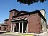 Ramsdell Theatre |
January 13, 1972 (#72000640) |
101 Maple St. 44°14′44″N 86°19′23″W |
Manistee | |
| 16 | Sandenburgh-Rogers Summer Resort Complex | 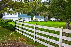 Sandenburgh-Rogers Summer Resort Complex |
December 6, 1996 (#96001421) |
2046 Crescent Beach Rd., Onekama Township 44°21′28″N 86°15′41″W |
Parkdale | |
| 17 | Udell Lookout Tower | 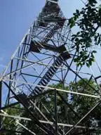 Udell Lookout Tower |
August 22, 1996 (#95001013) |
Forest Rd. 5207, Huron-Manistee National Forest 44°12′29″N 86°05′59″W |
Wellston | |
| 18 | Walther League Camp – Camp Arcadia | 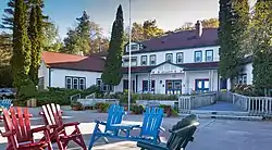 Walther League Camp – Camp Arcadia |
April 17, 2017 (#100000884) |
3046 Oak St. 44°29′45″N 86°14′27″W |
Arcadia Township |
See also
| Wikimedia Commons has media related to National Register of Historic Places in Manistee County, Michigan. |
References
- The latitude and longitude information provided in this table was derived originally from the National Register Information System, which has been found to be fairly accurate for about 99% of listings. Some locations in this table may have been corrected to current GPS standards.
- "National Register of Historic Places: Weekly List Actions". National Park Service, United States Department of the Interior. Retrieved on February 5, 2021.
- Numbers represent an alphabetical ordering by significant words. Various colorings, defined here, differentiate National Historic Landmarks and historic districts from other NRHP buildings, structures, sites or objects.
- "National Register Information System". National Register of Historic Places. National Park Service. April 24, 2008.
- The eight-digit number below each date is the number assigned to each location in the National Register Information System database, which can be viewed by clicking the number.
- "S.S. City of Milwaukee - History". Archived from the original on July 25, 2011. Retrieved July 28, 2011.
- "Car Ferry". Retrieved April 22, 2020.
External links
- Michigan State Historic Preservation Office
- National Park Service, National Register of Historic Places site
| Lists by county |
|  |
|---|---|---|
| Other lists |
| |
Municipalities and communities of Manistee County, Michigan, United States | ||
|---|---|---|
| City | Map of Michigan highlighting Manistee County.svg | |
| Villages | ||
| Charter township | ||
| General law townships | ||
| CDPs | ||
| Other unincorporated communities | ||
| Indian reservation | ||
| Footnotes | ‡This populated place also has portions in an adjacent county or counties | |
| ||
This article is issued from Wikipedia. The text is licensed under Creative Commons - Attribution - Sharealike. Additional terms may apply for the media files.