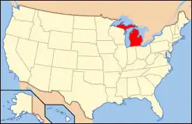
National Register of Historic Places listings in Eaton County, Michigan
The following is a list of Registered Historic Places in Eaton County, Michigan.
- This National Park Service list is complete through NPS recent listings posted February 5, 2021.[1]
| [2] | Name on the Register[3] | Image | Date listed[4] | Location | City or town | Description |
|---|---|---|---|---|---|---|
| 1 | 9622nd Army Air Corps Reserve Recovery Unit-Civil Air Patrol Quonset Huts | 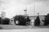 9622nd Army Air Corps Reserve Recovery Unit-Civil Air Patrol Quonset Huts |
August 16, 1991 (#91001017) |
16601 Airport Rd. 42°46′31″N 84°36′09″W |
Lansing | |
| 2 | Bellevue Mill | 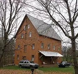 Bellevue Mill |
March 4, 1975 (#75000942) |
218 E. Mill St. 42°26′46″N 85°01′00″W |
Bellevue | |
| 3 | Charlotte Central Historic District | 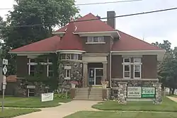 Charlotte Central Historic District |
October 16, 2020 (#100002684) |
Cochran Ave. & adjacent streets; West McClure St. to south of Henry St. 42°33′44″N 84°50′09″W |
Charlotte | |
| 4 | Eaton County Courthouse | 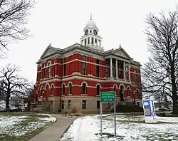 Eaton County Courthouse |
April 2, 1971 (#71000389) |
W. Lawrence Ave. at Cochran and Bostwick Sts.; also 100 W. Lawrence and 120 N. Bostwick 42°33′52″N 84°50′12″W |
Charlotte | Second set of boundaries represents a boundary increase of August 2, 1993. Now used as a museum. |
| 5 | First Congregational Church | 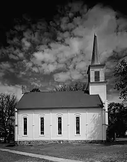 First Congregational Church |
September 3, 1971 (#71000390) |
341 S. Main St. 42°37′45″N 85°01′31″W |
Vermontville | |
| 6 | First Congregational Church | 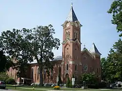 First Congregational Church |
August 26, 1993 (#93000872) |
106 S. Bostwick St. 42°33′49″N 84°50′16″W |
Charlotte | |
| 7 | Grand Ledge Chair Company Plant |  Grand Ledge Chair Company Plant |
November 3, 1987 (#87001377) |
101 Perry St. 42°45′25″N 84°45′18″W |
Grand Ledge | |
| 8 | Hance House | 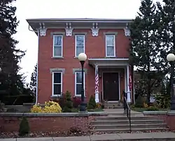 Hance House |
August 21, 1972 (#72000609) |
217 Yale St. 42°26′23″N 84°55′19″W |
Olivet | |
| 9 | Island City Historic District |  Island City Historic District |
August 28, 2012 (#12000557) |
N. & S. Main, E. & W. Hamlin, E. & W. Knight, King, Hall, & Spicer Sts. 42°30′39″N 84°39′23″W |
Eaton Rapids | |
| 10 | Michigan Central Railroad Charlotte Depot | 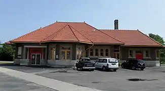 Michigan Central Railroad Charlotte Depot |
March 15, 2000 (#00000218) |
430 N. Cochran Ave. 42°34′07″N 84°50′09″W |
Charlotte | |
| 11 | Powers Highway-Battle Creek Bridge | 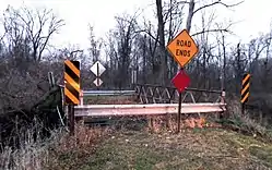 Powers Highway-Battle Creek Bridge |
January 7, 2000 (#99001653) |
Powers Highway over Battle Creek 42°27′16″N 84°48′24″W |
Brookfield Township | |
| 12 | Residential Drive-Townline Brook Bridge | January 7, 2000 (#99001652) |
Residential Drive over Townline Bridge 42°28′39″N 84°57′11″W |
Walton Township | ||
| 13 | Isaac N. Reynolds House | 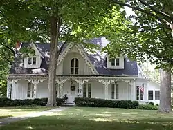 Isaac N. Reynolds House |
July 18, 1974 (#74000983) |
123 N. East St. 42°30′49″N 84°39′04″W |
Eaton Rapids | |
| 14 | River Ledge Historic District | 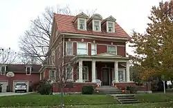 River Ledge Historic District |
September 24, 1987 (#87001576) |
Jefferson, Scott, and Lincoln Sts. between Franklin and Maple Sts. 42°45′07″N 84°44′49″W |
Grand Ledge | |
| 15 | Sunfield Grand Army of the Republic Post No. 283 Hall | 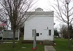 Sunfield Grand Army of the Republic Post No. 283 Hall |
October 29, 1992 (#92001502) |
115 Main St. 42°45′44″N 84°59′41″W |
Sunfield | |
| 16 | Vermontville Chapel and Academy | 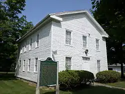 Vermontville Chapel and Academy |
August 7, 1972 (#72000610) |
N. Main St. 42°37′48″N 85°01′31″W |
Vermontville | |
| 17 | Vermontville Opera House | 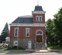 Vermontville Opera House |
July 14, 1993 (#93000620) |
120 E. 1st St. and 219 S. Main St. 42°37′37″N 85°01′28″W |
Vermontville |
See also
| Wikimedia Commons has media related to National Register of Historic Places in Eaton County, Michigan. |
- List of Registered Historic Places in Michigan
- List of Michigan State Historic Sites in Eaton County, Michigan
References
- "National Register of Historic Places: Weekly List Actions". National Park Service, United States Department of the Interior. Retrieved on February 5, 2021.
- Numbers represent an alphabetical ordering by significant words. Various colorings, defined here, differentiate National Historic Landmarks and historic districts from other NRHP buildings, structures, sites or objects.
- "National Register Information System". National Register of Historic Places. National Park Service. April 24, 2008.
- The eight-digit number below each date is the number assigned to each location in the National Register Information System database, which can be viewed by clicking the number.
| Lists by county |
|  |
|---|---|---|
| Other lists |
| |
| Topics | |
|---|---|
| Lists by state |
|
| Lists by insular areas | |
| Lists by associated state | |
| Other areas | |
| Related | |
| |
This article is issued from Wikipedia. The text is licensed under Creative Commons - Attribution - Sharealike. Additional terms may apply for the media files.