National Register of Historic Places listings in St. Joseph County, Michigan
This is a list of the National Register of Historic Places listings in St. Joseph County, Michigan.
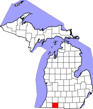
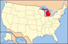
Location of St. Joseph County in Michigan
This is intended to be a complete list of the properties and districts on the National Register of Historic Places in St. Joseph County, Michigan, United States. Latitude and longitude coordinates are provided for many National Register properties and districts; these locations may be seen together in a map.[1]
There are 15 properties and districts listed on the National Register in the county.
- This National Park Service list is complete through NPS recent listings posted February 5, 2021.[2]
Current listings
| [3] | Name on the Register[4] | Image | Date listed[5] | Location | City or town | Description |
|---|---|---|---|---|---|---|
| 1 | Art Gallery Building |  Art Gallery Building |
May 9, 1980 (#80004070) |
156 S. Washington St. 41°50′29″N 85°40′08″W |
Constantine | |
| 2 | Gov. John S. Barry House† | 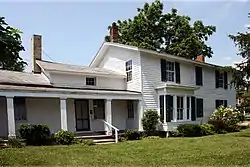 Gov. John S. Barry House† |
March 16, 1972 (#72001308) |
280 N. Washington St. 41°50′44″N 85°40′19″W |
Constantine | |
| 3 | Leverett A. and Amanda (Hampson) Clapp House† | 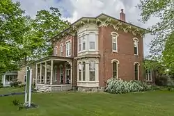 Leverett A. and Amanda (Hampson) Clapp House† |
July 1, 2009 (#09000476) |
324 W. Main St. 41°55′26″N 85°31′50″W |
Centreville | |
| 4 | Constantine Historic Commercial District |  Constantine Historic Commercial District |
September 17, 1985 (#85002444) |
Washington St. between 2nd and Water, and Water St. between White Pigeon and 125 W. Water 41°50′31″N 85°40′08″W |
Constantine | |
| 5 | Downtown Three Rivers Commercial Historic District† |  Downtown Three Rivers Commercial Historic District† |
April 29, 1982 (#82004472) |
N. Main St., Michigan and Portage Aves. 41°56′42″N 85°38′01″W |
Three Rivers | |
| 6 | Farrand Hall† | 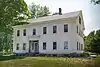 Farrand Hall† |
August 25, 1972 (#72001307) |
451 Farrand Rd. 41°56′54″N 85°20′33″W |
Colon | |
| 7 | Marantette Bridge† | 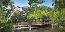 Marantette Bridge† |
June 25, 2001 (#01000708) |
Railroad St., Buckner Rd. over the St. Joseph River 41°59′56″N 85°27′30″W |
Mendon | |
| 8 | Marantette House† | 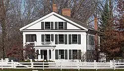 Marantette House† |
April 11, 1973 (#73001947) |
25538 Simpson Rd. 42°00′00″N 85°27′19″W |
Mendon | |
| 9 | Morse–Scoville House† | 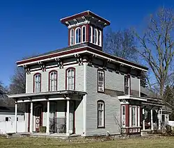 Morse–Scoville House† |
July 25, 1996 (#96000801) |
685 S. Washington 41°50′13″N 85°39′53″W |
Constantine | |
| 10 | Nottawa Stone School† | 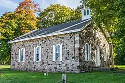 Nottawa Stone School† |
January 13, 1972 (#72001309) |
East of Nottawa at the junction of Sturgis and Filmore Rds. 41°55′10″N 85°26′25″W |
Nottawa | |
| 11 | Arthur Silliman House† | 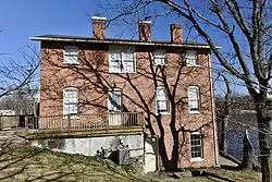 Arthur Silliman House† |
November 20, 1979 (#79002662) |
116 S. Main St. 41°56′37″N 85°37′55″W |
Three Rivers | |
| 12 | St. Joseph County Courthouse† | 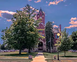 St. Joseph County Courthouse† |
September 16, 1993 (#93000984) |
125 W. Main St. 41°55′22″N 85°31′41″W |
Centreville | |
| 13 | US 12 St. Joseph River Bridge† | 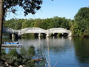 US 12 St. Joseph River Bridge† |
April 5, 1991 (#91000388) |
U. S. Route 12 over the St. Joseph River, Mottville Township 41°48′00″N 85°45′25″W |
Mottville | |
| 14 | Old US Government Land Office Building | 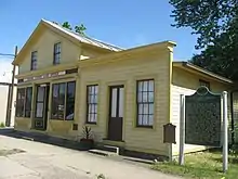 Old US Government Land Office Building |
February 7, 1989 (#88003234) |
113 W. Chicago Rd. 41°47′52″N 85°38′38″W |
White Pigeon | |
| 15 | Wahbememe Burial Site and Monument† | 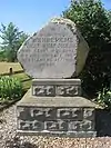 Wahbememe Burial Site and Monument† |
July 21, 1995 (#95000867) |
Junction of U.S. Routes 12 and 131, Mottville Township 41°47′51″N 85°39′47″W |
White Pigeon |
Listings Formerly Located in St. Joseph County
The following listings were located in St. Joseph County at the time they were placed on the Register, but have since moved to other locations.
| Name on the Register |
Image | Date listed | Current Location | Location when Listed | Description | |
|---|---|---|---|---|---|---|
| 1 | M-86–Prairie River Bridge | 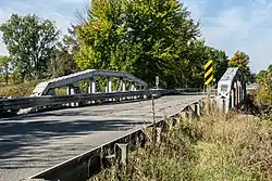 M-86–Prairie River Bridge |
February 4, 2000 (#00000044) |
Crystal Springs Street over the Dowagiac River, Pokagon Township, Michigan 41°55′31″N 86°12′22″W |
M-86 over the Prairie River 41°55'08"N 85°28'54"W | This camelback truss bridge, constructed in 1923, was originally located on Telegraph Road over the Rouge River. It was moved to the M-86 location in St. Joseph County in 1938/39 and was in place for nearly 80 years. In 2016/2017, it was moved again, 50 miles away to Crystal Springs Street over the Dowagiac River in Cass County. |
See also
| Wikimedia Commons has media related to National Register of Historic Places in St. Joseph County, Michigan. |
References
- The latitude and longitude information provided in this table was derived originally from the National Register Information System, which has been found to be fairly accurate for about 99% of listings. Some locations in this table may have been corrected to current GPS standards.
- "National Register of Historic Places: Weekly List Actions". National Park Service, United States Department of the Interior. Retrieved on February 5, 2021.
- Numbers represent an alphabetical ordering by significant words. Various colorings, defined here, differentiate National Historic Landmarks and historic districts from other NRHP buildings, structures, sites or objects.
- "National Register Information System". National Register of Historic Places. National Park Service. April 24, 2008.
- The eight-digit number below each date is the number assigned to each location in the National Register Information System database, which can be viewed by clicking the number.
| Lists by county |
|  |
|---|---|---|
| Other lists |
| |
Municipalities and communities of St. Joseph County, Michigan, United States | ||
|---|---|---|
| Cities | Map of Michigan highlighting Saint Joseph County.svg | |
| Villages | ||
| Townships | ||
| Unincorporated communities | ||
| ||
This article is issued from Wikipedia. The text is licensed under Creative Commons - Attribution - Sharealike. Additional terms may apply for the media files.