National Register of Historic Places listings in Mariposa County, California
This is a list of the National Register of Historic Places listings in Mariposa County, California.
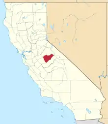
Location of Mariposa County in California
This is intended to be a complete list of the properties and districts on the National Register of Historic Places in Mariposa County, California, United States. Latitude and longitude coordinates are provided for many National Register properties and districts; these locations may be seen together in a Google map.[1]
There are 44 properties and districts listed on the National Register in the county, including 4 National Historic Landmarks.
- This National Park Service list is complete through NPS recent listings posted February 5, 2021.[2]
Current listings
| [3] | Name on the Register[4] | Image | Date listed[5] | Location | City or town | Description |
|---|---|---|---|---|---|---|
| 1 | Acting Superintendent's Headquarters | 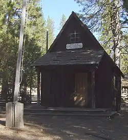 Acting Superintendent's Headquarters |
June 9, 1978 (#78000362) |
Yosemite National Park 37°32′20″N 119°39′17″W |
Wawona | |
| 2 | Ahwahnee Hotel | 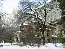 Ahwahnee Hotel |
February 15, 1977 (#77000149) |
Yosemite Valley 37°44′45″N 119°34′22″W |
Yosemite National Park | |
| 3 | Bagby Stationhouse, Water Tanks and Turntable | 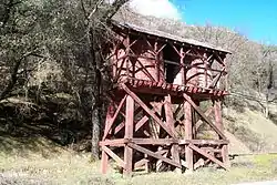 Bagby Stationhouse, Water Tanks and Turntable |
April 13, 1979 (#79000316) |
CA 140 37°40′27″N 119°46′47″W |
El Portal | |
| 4 | Big Gap Flume | May 12, 1975 (#75000438) |
East of Groveland off CA 120 in Stanislaus National Forest 37°49′19″N 120°03′34″W |
Groveland | ||
| 5 | Bower Cave | June 16, 2003 (#01000719) |
Address Restricted |
Greeley Hill | ||
| 6 | Camp 4 |  Camp 4 |
February 21, 2003 (#03000056) |
Northside Dr., Yosemite National Park 37°44′30″N 119°36′09″W |
Yosemite | |
| 7 | Camp Curry Historic District |  Camp Curry Historic District |
November 1, 1979 (#79000315) |
Yosemite Valley 37°44′36″N 119°34′16″W |
Yosemite National Park | |
| 8 | Coulterville Main Street Historic District |  Coulterville Main Street Historic District |
March 12, 1982 (#82002205) |
Main St. 37°42′38″N 120°11′50″W |
Coulterville | |
| 9 | Crane Flat Fire Lookout |  Crane Flat Fire Lookout |
April 4, 1996 (#96000354) |
North of Big Oak Flat Rd., near Crane Cr., Yosemite National Park 37°45′34″N 119°49′10″W |
Aspen Valley | part of the Historic Park Landscapes in National and State Parks Multiple Property Submission (MPS) |
| 10 | Degnan's Restaurant | 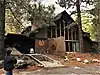 Degnan's Restaurant |
September 5, 2017 (#100001558) |
9001 Village Dr. 37°44′53″N 119°35′08″W |
Yosemite National Park | |
| 11 | El Portal Archeological District | August 18, 1978 (#78000359) |
Address Restricted |
Mariposa | ||
| 12 | El Portal Old Schoolhouse |  El Portal Old Schoolhouse |
February 1, 2011 (#10001190) |
Chapel Lane, Yosemite National Park 37°40′29″N 119°47′11″W |
El Portal | |
| 13 | Glacier Point Trailside Museum | 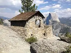 Glacier Point Trailside Museum |
April 4, 1978 (#78000357) |
East of El Portal in Yosemite National Park 37°43′50″N 119°34′23″W |
El Portal | |
| 14 | Half Dome Cables and Trail | 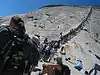 Half Dome Cables and Trail |
August 15, 2012 (#12000494) |
P.O. Box 577 37°44′49″N 119°31′47″W |
Yosemite | |
| 15 | Hetch Hetchy Railroad Engine No.6 | 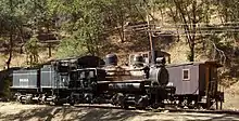 Hetch Hetchy Railroad Engine No.6 |
January 30, 1978 (#78000360) |
CA 140 37°40′30″N 119°46′46″W |
El Portal | |
| 16 | Hodgdon Homestead Cabin | 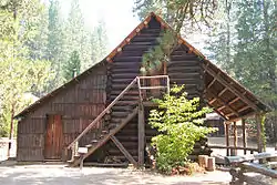 Hodgdon Homestead Cabin |
June 9, 1978 (#78000356) |
Yosemite National Park 37°32′20″N 119°39′19″W |
Wawona | |
| 17 | Hornitos Masonic Hall No. 98 | .jpg.webp) Hornitos Masonic Hall No. 98 |
August 3, 2005 (#05000775) |
2877 Bear Valley Rd. 37°30′05″N 120°14′14″W |
Hornitos | |
| 18 | Chris Jorgenson Studio | 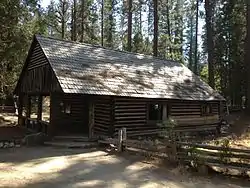 Chris Jorgenson Studio |
April 13, 1979 (#79000280) |
Pioneer Yosemite Historic Center 37°32′20″N 119°39′19″W |
Yosemite National Park | |
| 19 | LeConte Memorial Lodge | 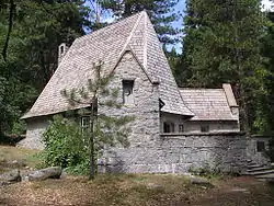 LeConte Memorial Lodge |
March 8, 1977 (#77000148) |
Yosemite Valley, Yosemite National Park 37°44′24″N 119°34′42″W |
Curry Village | |
| 20 | Mariposa County Courthouse | 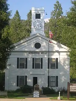 Mariposa County Courthouse |
December 7, 1977 (#77000306) |
5088 Bullion St. 37°29′20″N 119°57′59″W |
Mariposa | |
| 21 | Mariposa County High School Auditorium | Mariposa County High School Auditorium |
May 2, 1991 (#91000547) |
5074 Old Highway N. 37°29′21″N 119°57′47″W |
Mariposa | |
| 22 | Mariposa Grove Museum |  Mariposa Grove Museum |
December 1, 1978 (#78000381) |
Southeast of Wawona in Yosemite National Park 37°30′50″N 119°35′54″W |
Wawona | |
| 23 | Mariposa Town Historic District |  Mariposa Town Historic District |
May 15, 1991 (#91000560) |
Roughly bounded by Charles, 11th, Jones and 4th Sts. 37°29′14″N 119°57′54″W |
Mariposa | |
| 24 | McCauley and Meyer Barns | 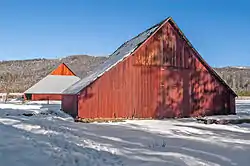 McCauley and Meyer Barns |
June 15, 1978 (#78000353) |
North of El Portal in Yosemite National Park 37°42′00″N 119°45′18″W |
El Portal | |
| 25 | McGurk Cabin | 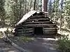 McGurk Cabin |
June 4, 1979 (#79000281) |
South of Yosemite Village 37°40′40″N 119°37′27″W |
Yosemite Village | |
| 26 | Merced Grove Ranger Station | Merced Grove Ranger Station |
June 15, 1978 (#78000358) |
North of El Portal in Yosemite National Park 37°44′56″N 119°50′21″W |
El Portal | |
| 27 | Merced Lake High Sierra Camp | July 18, 2014 (#14000407) |
Along North bank of Merced River, directly East of Merced Lake 37°44′24″N 119°24′24″W |
Yosemite | ||
| 28 | Merced Lake Ranger Station | July 18, 2014 (#14000408) |
Jct. of Merced Lake Tr. & Lewis Cr. 37°44′18″N 119°23′45″W |
Yosemite | ||
| 29 | Ostrander Lake Ski Hut | 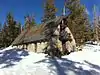 Ostrander Lake Ski Hut |
July 18, 2014 (#14000409) |
Ostrander Lake Tr. 37°37′36″N 119°32′59″W |
Yosemite | |
| 30 | Rangers' Club | Rangers' Club |
May 28, 1987 (#87001414) |
Yosemite Valley 37°44′50″N 119°35′12″W |
Yosemite National Park | |
| 31 | St. Joseph Catholic Church, Rectory and Cemetery |  St. Joseph Catholic Church, Rectory and Cemetery |
April 16, 1991 (#91000424) |
4983-4985 Bullion St. 37°28′57″N 119°57′37″W |
Mariposa | |
| 32 | Snow Creek Ski Hut | July 18, 2014 (#14000410) |
Off Tanaya Lake Trail, westerly shoulder of Mt. Watkins 37°47′17″N 119°31′22″W |
Yosemite | ||
| 33 | Snow Flat Snow Survey Shelter | July 18, 2014 (#14000411) |
Terminus of service road off May Lake Rd. 37°49′31″N 119°29′52″W |
Yosemite | ||
| 34 | Sunrise High Sierra Camp | July 18, 2014 (#14000412) |
Along North bank of Long Meadow Creek, overlooking Long Meadow (southeast of Sunrise Lakes) 37°47′43″N 119°25′58″W |
Yosemite | ||
| 35 | Track Bus No. 19 | 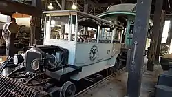 Track Bus No. 19 |
May 22, 1978 (#78000363) |
CA 140 37°40′30″N 119°46′46″W |
El Portal | |
| 36 | Vogelsang High Sierra Camp |  Vogelsang High Sierra Camp |
July 18, 2014 (#14000413) |
Along Fletcher Creek, immediately southwest of Fletcher Lake 37°47′43″N 119°20′44″W |
Yosemite | |
| 37 | Wawona Covered Bridge | 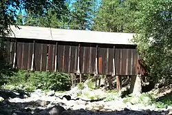 Wawona Covered Bridge |
January 11, 2007 (#06001261) |
Pioneer Yosemite History Center 37°32′19″N 119°39′17″W |
Wawona | |
| 38 | Wawona Hotel and Pavilion | 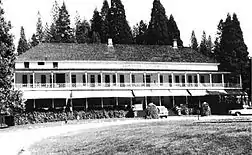 Wawona Hotel and Pavilion |
October 1, 1975 (#75000223) |
On CA 41 in Yosemite National Park 37°32′11″N 119°39′13″W |
Wawona | |
| 39 | Yosemite Transportation Company Office | Yosemite Transportation Company Office |
June 9, 1978 (#78000355) |
North of Wawona in Yosemite National Park 37°32′20″N 119°39′17″W |
Wawona | |
| 40 | Yosemite Valley Archeological District | January 20, 1978 (#78000361) |
Address Restricted |
Yosemite Village | ||
| 41 | Yosemite Valley Bridges | 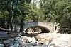 Yosemite Valley Bridges |
November 25, 1977 (#77000160) |
8 Bridges over Merced River, Yosemite National Park 37°43′58″N 119°36′00″W |
Yosemite Village | |
| 42 | Yosemite Valley Chapel | 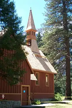 Yosemite Valley Chapel |
December 12, 1973 (#73000256) |
Off CA 140 37°44′27″N 119°35′26″W |
Yosemite National Park | |
| 43 | Yosemite Valley Railroad Caboose No. 15 | 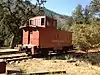 Yosemite Valley Railroad Caboose No. 15 |
May 22, 1978 (#78000352) |
CA 140 37°40′30″N 119°46′46″W |
El Portal | |
| 44 | Yosemite Village Historic District | 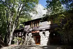 Yosemite Village Historic District |
March 30, 1978 (#78000354) |
East of El Portal in Yosemite National Park 37°44′55″N 119°35′18″W |
El Portal |
Former listing
| [3] | Name on the Register | Image | Date listed | Date removed | Location | City or town | Summary |
|---|---|---|---|---|---|---|---|
| 1 | Degnan House and Bakery |  Degnan House and Bakery |
1975 (#75002146) | Unknown | Southside Dr., Yosemite National Park |
Yosemite Village | House was removed, while bakery was relocated to the Pioneer History Center.[6] |
See also
| Wikimedia Commons has media related to National Register of Historic Places in Mariposa County, California. |
References
- The latitude and longitude information provided in this table was derived originally from the National Register Information System, which has been found to be fairly accurate for about 99% of listings. Some locations in this table may have been corrected to current GPS standards.
- "National Register of Historic Places: Weekly List Actions". National Park Service, United States Department of the Interior. Retrieved on February 5, 2021.
- Numbers represent an alphabetical ordering by significant words. Various colorings, defined here, differentiate National Historic Landmarks and historic districts from other NRHP buildings, structures, sites or objects.
- "National Register Information System". National Register of Historic Places. National Park Service. July 9, 2010.
- The eight-digit number below each date is the number assigned to each location in the National Register Information System database, which can be viewed by clicking the number.
| Topics | |
|---|---|
| Lists by state |
|
| Lists by insular areas | |
| Lists by associated state | |
| Other areas | |
| Related | |
| |
Municipalities and communities of Mariposa County, California, United States | ||
|---|---|---|
| CDPs | Mariposa County map | |
| Unincorporated communities | ||
| Former settlements | ||
| ||
This article is issued from Wikipedia. The text is licensed under Creative Commons - Attribution - Sharealike. Additional terms may apply for the media files.