National Register of Historic Places listings in Santa Barbara County, California
This is a list of the National Register of Historic Places listings in Santa Barbara County, California.
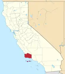
Location of Santa Barbara County in California
This is intended to be a complete list of the properties and districts on the National Register of Historic Places in Santa Barbara County, California, United States. Latitude and longitude coordinates are provided for many National Register properties and districts; these locations may be seen together in an online map.[1]
There are 45 properties and districts listed on the National Register in the county, including 8 National Historic Landmarks.
- This National Park Service list is complete through NPS recent listings posted January 29, 2021.[2]
Current listings
| [3] | Name on the Register[4] | Image | Date listed[5] | Location | City or town | Description |
|---|---|---|---|---|---|---|
| 1 | Acacia Lodge |  Acacia Lodge |
July 9, 1997 (#97000750) |
109 Miramar Ave. 34°25′22″N 119°37′49″W |
Santa Barbara | |
| 2 | Andalucia Building |  Andalucia Building |
December 22, 1999 (#99001592) |
316-324 State St. 34°24′57″N 119°41′37″W |
Santa Barbara | |
| 3 | Campbell No. 2 Archeological Site | January 25, 1993 (#92001755) |
Address Restricted |
Goleta | ||
| 4 | Eastern Sierra Madre Ridge Archeological District | December 19, 1978 (#78000779) |
Address Restricted |
New Cuyama | ||
| 5 | El Paseo and Casa de la Guerra | 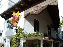 El Paseo and Casa de la Guerra |
February 2, 1977 (#77000346) |
808-818 State St., 813-819 Anacapa St., and 9-25 E. de la Guerra St. 34°25′14″N 119°41′57″W |
Santa Barbara | El Paseo and Casa de la Guerra |
| 6 | Faith Mission | 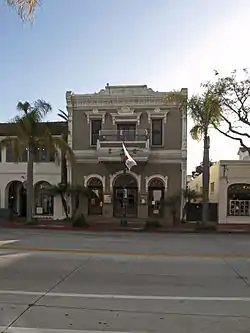 Faith Mission |
January 11, 1982 (#82002269) |
409 State St. 34°24′58″N 119°41′41″W |
Santa Barbara | Designed by Peter J. Barber |
| 7 | Goleta Depot | 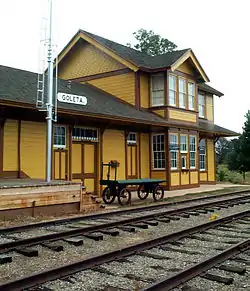 Goleta Depot |
January 18, 2002 (#01001457) |
300 N. Los Carneros Rd. 34°26′33″N 119°51′09″W |
Goleta | A 1901 Southern Pacific train station, now located at the South Coast Railroad Museum |
| 8 | Rafael Gonzalez House |  Rafael Gonzalez House |
April 15, 1970 (#70000149) |
835 Laguna St. 34°25′27″N 119°41′45″W |
Santa Barbara | A National Historic Landmark |
| 9 | Hammond's Estate Site | May 19, 1978 (#78000782) |
Address Restricted |
Santa Barbara | ||
| 10 | Allan Herschell 3-Abreast Carousel | 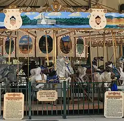 Allan Herschell 3-Abreast Carousel |
April 13, 2000 (#00000363) |
223 E. Cabrillo Blvd. 34°24′54″N 119°41′10″W |
Santa Barbara | |
| 11 | Hill-Carrillo Adobe | 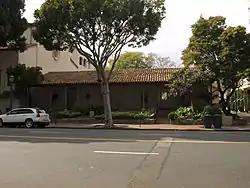 Hill-Carrillo Adobe |
January 14, 1986 (#86000778) |
11 E. Carrillo St. 34°25′19″N 119°42′06″W |
Santa Barbara | |
| 12 | Thomas Hope House | December 1, 1978 (#78000783) |
399 Nogal Dr. 34°26′06″N 119°46′15″W |
Santa Barbara | Designed by Peter J. Barber | |
| 13 | Janssens-Orella-Birk Building | 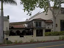 Janssens-Orella-Birk Building |
July 16, 1987 (#87001170) |
1029-1031 State St. 34°25′20″N 119°42′11″W |
Santa Barbara | |
| 14 | La Purisima Mission |  La Purisima Mission |
April 15, 1970 (#70000147) |
4 mi. E of Lompoc, near jct. of CA 1 and 150 34°40′31″N 120°25′19″W |
Lompoc | A National Historic Landmark |
| 15 | Lompoc Public Library | 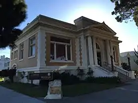 Lompoc Public Library |
December 10, 1990 (#90001818) |
200 S. H St. 34°38′14″N 120°27′27″W |
Lompoc | |
| 16 | Lompoc Veterans Memorial Building |  Lompoc Veterans Memorial Building |
September 19, 2016 (#16000664) |
100 E. Locust Ave. 34°37′57″N 120°27′28″W |
Lompoc | |
| 17 | Los Alamos Ranch House | 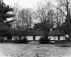 Los Alamos Ranch House |
April 15, 1970 (#70000148) |
3 mi. W of Los Alamos on old U.S. 101 34°45′10″N 120°19′20″W |
Los Alamos | A National Historic Landmark |
| 18 | Los Banos del Mar |  Los Banos del Mar |
December 24, 1992 (#92001726) |
401 Shoreline Dr. 34°24′28″N 119°41′38″W |
Santa Barbara | |
| 19 | Madulce Guard Station and Site | December 11, 1979 (#79000547) |
40 mi. N. of Santa Barbara 34°42′11″N 119°34′42″W |
Santa Barbara | Destroyed by fire in 1999.[6] | |
| 20 | Minerva Club of Santa Maria | 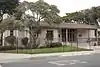 Minerva Club of Santa Maria |
September 20, 1984 (#84001193) |
127 W. Boone St. 34°56′51″N 120°26′14″W |
Santa Maria | |
| 21 | Mission de la Purisima Concepcion de Maria Santisima Site | 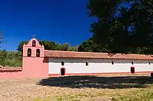 Mission de la Purisima Concepcion de Maria Santisima Site |
May 5, 1978 (#78000775) |
Bounded by Locust Ave., city limits, E and G Sts. 34°37′55″N 120°27′23″W |
Lompoc | |
| 22 | Mission Santa Ines | 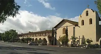 Mission Santa Ines |
March 8, 1999 (#99000630) |
E side of Solvang, S of CA 246 34°35′37″N 120°08′14″W |
Solvang | A National Historic Landmark District |
| 23 | Painted Cave | 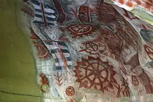 Painted Cave |
December 5, 1972 (#72000256) |
Address Restricted |
Santa Barbara | |
| 24 | Point Conception Light Station | 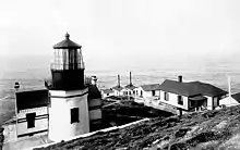 Point Conception Light Station |
February 25, 1981 (#81000176) |
U.S. Coast Guard Light Station 34°26′55″N 120°28′15″W |
Santa Barbara | |
| 25 | Point Sal Ataje | November 21, 2002 (#02001392) |
Address Restricted |
Point Sal Highlands | ||
| 26 | Rattlesnake Canyon Bridge |  Rattlesnake Canyon Bridge |
January 17, 2017 (#100000465) |
1819 Las Canoas Rd. 34°27′27″N 119°41′32″W |
Santa Barbara | |
| 27 | San Marcos Rancho | April 26, 1979 (#79000548) |
Address Restricted |
Santa Barbara | ||
| 28 | San Miguel Island Archeological District | September 12, 1979 (#79000258) |
Address Restricted |
Santa Barbara | ||
| 29 | Santa Barbara Club | May 13, 2019 (#100003919) |
1105 Chapala St. 34°25′17″N 119°42′17″W |
Santa Barbara | Clubhouse of club founded in 1892 | |
| 30 | Santa Barbara County Courthouse | 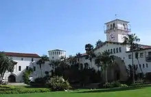 Santa Barbara County Courthouse |
January 23, 1981 (#81000177) |
1100 Anacapa St. 34°25′28″N 119°42′09″W |
Santa Barbara | A National Historic Landmark |
| 31 | Santa Barbara Island Archeological District | September 12, 1979 (#79000259) |
Address Restricted |
Santa Barbara | ||
| 32 | Santa Barbara Mission | 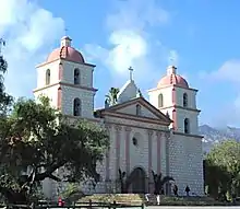 Santa Barbara Mission |
October 15, 1966 (#66000237) |
2201 Laguna St. 34°26′16″N 119°42′50″W |
Santa Barbara | A National Historic Landmark |
| 33 | Santa Barbara Presidio | 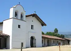 Santa Barbara Presidio |
November 26, 1973 (#73000455) |
Roughly bounded by Carrillo, Garden, De la Guerra and Anacapa Sts. 34°25′21″N 119°41′50″W |
Santa Barbara | |
| 34 | Santa Barbara Veterans Memorial Building | 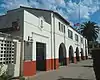 Santa Barbara Veterans Memorial Building |
March 22, 2016 (#16000097) |
112 W. Cabrillo St. 34°24′39″N 119°41′27″W |
Santa Barbara | Remodeled in 1937 in the Spanish Colonial Revival style from a 1927 building |
| 35 | Santa Cruz Island Archeological District | January 30, 1980 (#80000405) |
Address Restricted |
Santa Barbara | ||
| 36 | Joseph and Lucy Foster Sexton House | 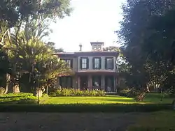 Joseph and Lucy Foster Sexton House |
February 5, 1992 (#91002033) |
5490 Hollister Ave. 34°26′09″N 119°48′55″W |
Santa Barbara | Italianate, designed by Peter J. Barber |
| 37 | Southern Pacific Train Depot | 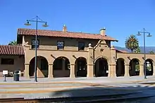 Southern Pacific Train Depot |
August 2, 2006 (#06000658) |
209 State St. 34°24′49″N 119°41′34″W |
Santa Barbara | |
| 38 | Space Launch Complex 10 | 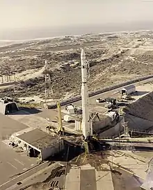 Space Launch Complex 10 |
June 23, 1986 (#86003511) |
Vandenberg Air Force Base 34°45′55″N 120°37′20″W |
Lompoc | A National Historic Landmark |
| 39 | SS YANKEE BLADE | May 16, 1991 (#91000564) |
Address Restricted |
Lompoc | ||
| 40 | St. Vincent Orphanage and School Building |  St. Vincent Orphanage and School Building |
June 2, 1982 (#82002270) |
925 De La Vina St. 34°25′08″N 119°42′15″W |
Santa Barbara | |
| 41 | Steedman Estate | 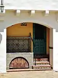 Steedman Estate |
January 29, 1987 (#87000002) |
1387 E. Valley Rd. 34°26′10″N 119°38′12″W |
Montecito | National Historic Landmark designation January 16, 2009 |
| 42 | Stow House | 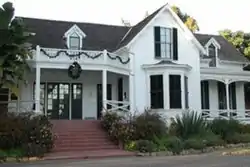 Stow House |
September 28, 2000 (#00001166) |
304 N. Los Carneros Rd. 34°26′35″N 119°51′06″W |
Goleta | |
| 43 | US Post Office-Santa Barbara Main |  US Post Office-Santa Barbara Main |
January 11, 1985 (#85000138) |
836 Anacapa St. 34°25′18″N 119°41′56″W |
Santa Barbara | |
| 44 | Val Verde | March 31, 1995 (#95000359) |
2549 Sycamore Canyon Rd. 34°26′26″N 119°38′58″W |
Montecito | Santa Barbara County landmark number: 38 Also known as: Dias Felices, Henry Dater house, Wright Ludington house, Dr. Warren Austin home | |
| 45 | Virginia Hotel | 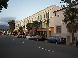 Virginia Hotel |
March 31, 2000 (#00000295) |
17 and 23 W. Haley St. 34°24′58″N 119°41′46″W |
Santa Barbara |
See also
| Wikimedia Commons has media related to National Register of Historic Places in Santa Barbara County, California. |
References
- The latitude and longitude information provided in this table was derived originally from the National Register Information System, which has been found to be fairly accurate for about 99% of listings. Some locations in this table may have been corrected to current GPS standards.
- "National Register of Historic Places: Weekly List Actions". National Park Service, United States Department of the Interior. Retrieved on January 29, 2021.
- Numbers represent an alphabetical ordering by significant words. Various colorings, defined here, differentiate National Historic Landmarks and historic districts from other NRHP buildings, structures, sites or objects.
- "National Register Information System". National Register of Historic Places. National Park Service. July 9, 2010.
- The eight-digit number below each date is the number assigned to each location in the National Register Information System database, which can be viewed by clicking the number.
| Topics | |
|---|---|
| Lists by state |
|
| Lists by insular areas | |
| Lists by associated state | |
| Other areas | |
| Related | |
| |
Municipalities and communities of Santa Barbara County, California, United States | ||
|---|---|---|
| Cities | Santa Barbara County map | |
| CDPs | ||
| Unincorporated communities | ||
| Indian reservation | ||
| Ghost towns | ||
| ||
This article is issued from Wikipedia. The text is licensed under Creative Commons - Attribution - Sharealike. Additional terms may apply for the media files.