National Register of Historic Places listings in Union County, South Dakota
This is a list of the National Register of Historic Places listings in Union County, South Dakota.
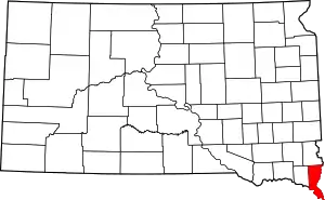
Location of Union County in South Dakota
This is intended to be a complete list of the properties and districts on the National Register of Historic Places in Union County, South Dakota, United States. The locations of National Register properties and districts for which the latitude and longitude coordinates are included below, may be seen in a map.[1]
There are 16 properties and districts listed on the National Register in the county.
- This National Park Service list is complete through NPS recent listings posted January 29, 2021.[2]
Current listings
| [3] | Name on the Register[4] | Image | Date listed[5] | Location | City or town | Description |
|---|---|---|---|---|---|---|
| 1 | Baker House | _from_W_1.JPG.webp) Baker House |
August 7, 1979 (#79002409) |
48113 SD Highway 48[6] 42°50′38″N 96°35′06″W |
Alcester | |
| 2 | Governor William J. Bulow House | 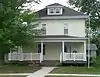 Governor William J. Bulow House |
May 8, 1986 (#86001024) |
207 W. Hemlock St. 43°04′53″N 96°46′35″W |
Beresford | |
| 3 | Chicago and Northwestern Railroad Depot | 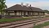 Chicago and Northwestern Railroad Depot |
January 31, 1985 (#85000262) |
1 Depot Sq. 43°04′50″N 96°46′13″W |
Beresford | |
| 4 | Hultgren Farm |  Hultgren Farm |
January 28, 2004 (#03001536) |
47953 309th St. 42°54′15″N 96°37′00″W |
Big Springs | |
| 5 | Hyden House | _from_NW_1.JPG.webp) Hyden House |
July 5, 1996 (#96000742) |
405 Hyden House 43°01′18″N 96°37′31″W |
Alcester | |
| 6 | John August Larson Home | _from_N_1.JPG.webp) John August Larson Home |
October 31, 1985 (#85003451) |
407 W. Hemlock 43°04′53″N 96°46′46″W |
Beresford | |
| 7 | Junction City Rest Stop Tipi |  Junction City Rest Stop Tipi |
January 20, 2015 (#14001191) |
Mi. 26.6 on I-29 42°47′05″N 96°47′15″W |
Junction City | Part of the Concrete Interstate Tipis of South Dakota MPS |
| 8 | Charles Murtha House and Brick Yard | 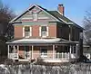 Charles Murtha House and Brick Yard |
February 1, 1982 (#82003945) |
707 W. Main St.[7] 42°41′26″N 96°41′32″W |
Elk Point | |
| 9 | Nora Store | 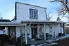 Nora Store |
November 20, 2007 (#07001215) |
30705 475th Ave. 42°56′25″N 96°42′25″W |
Alcester | |
| 10 | J.W. Reedy House | December 13, 1984 (#84000605) |
309 N. 2nd[8] 43°05′01″N 96°46′21″W |
Beresford | ||
| 11 | St. Paul Lutheran Church and Cemetery | February 20, 2018 (#100002103) |
31903 475th Ave. 42°45′53″N 96°42′28″W |
Richland vicinity | ||
| 12 | St. Peter's Catholic Church | 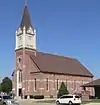 St. Peter's Catholic Church |
July 19, 1989 (#89000833) |
400 Main St. 42°36′15″N 96°33′37″W |
Jefferson | |
| 13 | South Dakota Dept. of Transportation Bridge No. 64-061-199 | December 9, 1993 (#93001322) |
Local road over Brule Creek 42°47′39″N 96°41′08″W |
Elk Point | ||
| 14 | Star School District 61 |  Star School District 61 |
February 19, 2008 (#08000056) |
47446 305th St. 42°58′06″N 96°43′02″W |
Alcester | |
| 15 | Swanson House | 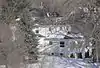 Swanson House |
May 31, 2006 (#06000461) |
30572 483rd Ave. 42°57′22″N 96°32′50″W |
Alcester | |
| 16 | United Brethren Church | _from_SSE_3.JPG.webp) United Brethren Church |
February 9, 2001 (#01000091) |
31141 476th Ave. 42°52′28″N 96°41′16″W |
Spink |
See also
| Wikimedia Commons has media related to National Register of Historic Places in Union County, South Dakota. |
References
- The latitude and longitude information provided in this table was derived originally from the National Register Information System, which has been found to be fairly accurate for about 99% of listings. Some locations in this table may have been corrected to current GPS standards.
- "National Register of Historic Places: Weekly List Actions". National Park Service, United States Department of the Interior. Retrieved on January 29, 2021.
- Numbers represent an alphabetical ordering by significant words. Various colorings, defined here, differentiate National Historic Landmarks and historic districts from other NRHP buildings, structures, sites or objects.
- "National Register Information System". National Register of Historic Places. National Park Service. April 24, 2008.
- The eight-digit number below each date is the number assigned to each location in the National Register Information System database, which can be viewed by clicking the number.
- "Akron - Front and Side Facade;Akron - 48113 SD Highway 48;Akron - Baker House". Labelled photo at South Dakota Digital Archives. Retrieved 2015-09-30.
- "Grand Opening of Union County Historical Society new museum". WNAX Radio. No date. Retrieved 2015-10-15.
- The address 309 N. 2nd appears on the NRHP nominating form, retrieved 2015-09-30. It was incorrectly transcribed as 304 N. 2nd in the NRIS database.
| Topics | |
|---|---|
| Lists by state |
|
| Lists by insular areas | |
| Lists by associated state | |
| Other areas | |
| Related | |
| |
Municipalities and communities of Union County, South Dakota, United States | ||
|---|---|---|
| Cities | | |
| Townships | ||
| CDPs | ||
| Other unincorporated communities | ||
| Ghost town | ||
| Footnotes | ‡This populated place also has portions in an adjacent county or counties | |
| ||
This article is issued from Wikipedia. The text is licensed under Creative Commons - Attribution - Sharealike. Additional terms may apply for the media files.