Nebraska Highway 11
Nebraska Highway 11 (N‑11) is a state highway in central and northern Nebraska, United States. Its southern terminus is at Interstate 80 (I‑80) south of Wood River. Its northern terminus is at the South Dakota border north of Butte. The highway goes through the eastern portion of the Sand Hills.
| ||||
|---|---|---|---|---|
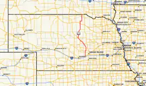 Nebraska Highway 11 highlighted in red | ||||
| Route information | ||||
| Maintained by NDOT | ||||
| Length | 183.66 mi[1] (295.57 km) | |||
| Existed | 1926[2]–present | |||
| Major junctions | ||||
| South end | ||||
| North end | ||||
| Location | ||||
| Counties | Hall, Howard, Greeley, Valley, Garfield, Holt, Boyd | |||
| Highway system | ||||
| ||||

Route description
N‑11 begins at Exit 300 of I‑80, which is also the exit for NE Spur 40D. It goes north through farmland into Wood River, where it crosses over U.S. Route 30 in Nebraska (US 30) without an interchange. Access to US 30 is available via Link 40G 0.5 miles (0.8 km) to the north. It continues north through Cairo, then meets Nebraska Highway 58. The two highways run concurrent, heading northeast to Dannebrog, where they separate. N‑11 proceeds north to Elba, then turns northwest on an alignment that parallels the North Loup River. It passes through Ord and Burwell, then turns north after passing Nebraska Highway 91. N‑11 continues north into areas of prairie and meets U.S. Route 20 in Atkinson. N‑11 goes north into farmland some more, briefly goes east, then turns north to go through Butte, where it meets Nebraska Highway 12 (N‑12). After a brief concurrency with N‑12, N‑11 turns north and goes into South Dakota, where the road continues as South Dakota Highway 43.[1][3]
Major intersections
| County | Location | mi[1] | km | Destinations | Notes |
|---|---|---|---|---|---|
| Hall | | 0.00 | 0.00 | Road continues south as Spur 40D | |
| | 0.14 | 0.23 | |||
| Wood River | 5.13 | 8.26 | Provides access to US 30 | ||
| Cairo | 17.51 | 28.18 | |||
| Howard | | 22.70 | 36.53 | Southern end of NE‑58 concurrency | |
| Dannebrog | 27.75 | 44.66 | Northern end of NE‑58 concurrency | ||
| | 34.68 | 55.81 | |||
| Greeley | Scotia | 54.65 | 87.95 | Southern end of NE‑22 concurrency | |
| Valley | North Loup | 56.68 | 91.22 | Northern end of NE‑22 concurrency | |
| Ord | 70.45 | 113.38 | Southern end of NE‑70 concurrency | ||
| 71.31 | 114.76 | Northern end of NE‑70 concurrency | |||
| Garfield | Burwell | 86.51 | 139.22 | Southern end of NE‑91 concurrency | |
| 88.50 | 142.43 | Northern end of NE‑91 concurrency | |||
| Holt | Amelia | 120.32 | 193.64 | ||
| Atkinson | 143.18 | 230.43 | Southern end of US 20 concurrency | ||
| 143.69 | 231.25 | Northern end of US 20 concurrency | |||
| Boyd | Butte | 176.12 | 283.44 | Southern end of NE‑12 concurrency | |
| 177.12 | 285.05 | Northern end of NE‑12 concurrency | |||
| | 183.66 | 295.57 | Continuation into South Dakota | ||
1.000 mi = 1.609 km; 1.000 km = 0.621 mi
| |||||
See also
References
- "Nebraska Highway Reference Log Book" (PDF). Nebraska Department of Roads. 2015. pp. 41–44. Retrieved January 6, 2017.
- The Nebraska Highways Page: Highways 1 to 30 Archived 2011-06-29 at the Wayback Machine
- Google (2010-11-04). "overview of Nebraska Highway 11" (Map). Google Maps. Google. Retrieved 2010-11-04.