Valley County, Nebraska
Valley County is a county in the U.S. state of Nebraska. As of the 2010 United States Census, the population was 4,260.[1] Its county seat is Ord.[2]
Valley County | |
|---|---|
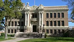 Valley County Courthouse in Ord | |
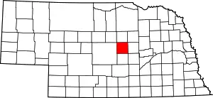 Location within the U.S. state of Nebraska | |
 Nebraska's location within the U.S. | |
| Coordinates: 41°34′N 98°59′W | |
| Country | |
| State | |
| Founded | 1871 (formed) 1873 (organized) |
| Seat | Ord |
| Largest city | Ord |
| Area | |
| • Total | 570 sq mi (1,500 km2) |
| • Land | 568 sq mi (1,470 km2) |
| • Water | 2.4 sq mi (6 km2) 0.4%% |
| Population | |
| • Estimate (2017) | 4,209 |
| • Density | 7.4/sq mi (2.9/km2) |
| Time zone | UTC−6 (Central) |
| • Summer (DST) | UTC−5 (CDT) |
| Congressional district | 3rd |
In the Nebraska license plate system, Valley County is represented by the prefix 47 (it had the 47th-largest number of vehicles registered in the county when the license plate system was established in 1922).
History
Valley County was formed in 1871 and organized in 1873.[3][4] Its name derives from the local terrain: much of the county consists of valley land lying between the North and Middle Loup Rivers.[5]
On June 12, 2010, the privately owned Bredthauer Dam broke due to heavy rain, flooding rural Valley County and the village of North Loup.[6][7] Major flooding occurred in the village, with water "eight inches deep and running down Main Street."[8] North Loup was evacuated for the flood's duration.[9]
Geography
The North Loup River flows southeastward through the upper portion of the county, while the Middle Loup River runs southeastward through the lower portion. The terrain consists of rolling hills. The flat river valleys are largely dedicated to agriculture, with some center pivot irrigation employed.[10] The county has an area of 570 square miles (1,500 km2), of which 568 square miles (1,470 km2) is land and 2.4 square miles (6.2 km2) (0.4%) is water.[11]
Protected area
- Fort Hartsuff State Historical Park[12]
- Scotia Canal State Wildlife Management Area[13]
Adjacent counties
- Wheeler County – northeast
- Greeley County – east
- Sherman County – south
- Custer County – west
- Garfield County – north
Demographics
| Historical population | |||
|---|---|---|---|
| Census | Pop. | %± | |
| 1880 | 2,324 | — | |
| 1890 | 7,092 | 205.2% | |
| 1900 | 7,339 | 3.5% | |
| 1910 | 9,480 | 29.2% | |
| 1920 | 9,823 | 3.6% | |
| 1930 | 9,533 | −3.0% | |
| 1940 | 8,163 | −14.4% | |
| 1950 | 7,252 | −11.2% | |
| 1960 | 6,590 | −9.1% | |
| 1970 | 5,783 | −12.2% | |
| 1980 | 5,633 | −2.6% | |
| 1990 | 5,169 | −8.2% | |
| 2000 | 4,647 | −10.1% | |
| 2010 | 4,260 | −8.3% | |
| 2017 (est.) | 4,209 | [14] | −1.2% |
| US Decennial Census[15] 1790-1960[16] 1900-1990[17] 1990-2000[18] 2010-2013[1] | |||
As of the 2000 United States Census,[19] there were 4,647 people, 1,965 households, and 1,298 families in the county. The population density was 8 people per square mile (3/km2). There were 2,273 housing units at an average density of 4 per square mile (2/km2). The racial makeup of the county was 98.15% White, 0.15% Black or African American, 0.32% Native American, 0.11% Asian, 0.06% Pacific Islander, 0.80% from other races, and 0.41% from two or more races. 1.61% of the population were Hispanic or Latino of any race.
There were 1,965 households, out of which 28.00% had children under the age of 18 living with them, 58.70% were married couples living together, 5.10% had a female householder with no husband present, and 33.90% were non-families. 31.00% of all households were made up of individuals, and 17.90% had someone living alone who was 65 years of age or older. The average household size was 2.32 and the average family size was 2.93.
The county population contained 24.70% under the age of 18, 4.80% from 18 to 24, 22.60% from 25 to 44, 23.90% from 45 to 64, and 24.00% who were 65 years of age or older. The median age was 44 years. For every 100 females there were 91.70 males. For every 100 females age 18 and over, there were 90.50 males.
The median income for a household in the county was $27,926, and the median income for a family was $35,571. Males had a median income of $25,224 versus $17,217 for females. The per capita income for the county was $14,996. About 10.10% of families and 12.80% of the population were below the poverty line, including 16.30% of those under age 18 and 12.70% of those age 65 or over.
Politics
Valley County voters are strongly Republican. In only one national election since 1916 has the county selected the Democratic Party candidate.
| Year | Republican | Democratic | Third Parties |
|---|---|---|---|
| 2016 | 80.7% 1,780 | 15.4% 339 | 3.9% 86 |
| 2012 | 75.5% 1,657 | 22.7% 498 | 1.8% 40 |
| 2008 | 68.4% 1,657 | 29.1% 706 | 2.5% 60 |
| 2004 | 75.3% 1,801 | 23.6% 564 | 1.1% 26 |
| 2000 | 71.1% 1,610 | 25.8% 583 | 3.1% 70 |
| 1996 | 56.3% 1,346 | 31.7% 758 | 12.0% 288 |
| 1992 | 45.3% 1,173 | 27.6% 716 | 27.1% 701 |
| 1988 | 64.1% 1,604 | 34.9% 873 | 1.0% 26 |
| 1984 | 73.2% 2,055 | 26.3% 739 | 0.5% 13 |
| 1980 | 71.7% 2,101 | 22.4% 655 | 5.9% 173 |
| 1976 | 57.3% 1,587 | 37.6% 1,042 | 5.1% 140 |
| 1972 | 72.3% 2,011 | 27.7% 771 | |
| 1968 | 64.4% 1,759 | 29.0% 793 | 6.6% 179 |
| 1964 | 51.8% 1,657 | 48.3% 1,545 | |
| 1960 | 62.1% 2,045 | 37.9% 1,248 | |
| 1956 | 66.8% 2,189 | 33.2% 1,089 | |
| 1952 | 71.9% 2,630 | 28.1% 1,027 | |
| 1948 | 54.7% 1,670 | 45.3% 1,385 | |
| 1944 | 58.7% 2,096 | 41.3% 1,475 | |
| 1940 | 60.6% 2,449 | 39.4% 1,590 | |
| 1936 | 49.7% 2,033 | 47.9% 1,960 | 2.5% 102 |
| 1932 | 39.0% 1,584 | 59.2% 2,400 | 1.8% 73 |
| 1928 | 69.3% 2,768 | 30.2% 1,205 | 0.6% 23 |
| 1924 | 55.0% 2,014 | 21.9% 802 | 23.0% 843 |
| 1920 | 64.8% 1,935 | 30.5% 912 | 4.7% 139 |
| 1916 | 36.4% 840 | 60.2% 1,388 | 3.3% 77 |
| 1912 | 26.7% 552 | 38.2% 788 | 35.1% 725 |
| 1908 | 48.5% 1,040 | 48.7% 1,045 | 2.8% 61 |
| 1904 | 63.9% 1,133 | 12.4% 219 | 23.7% 420 |
| 1900 | 47.4% 810 | 50.6% 864 | 2.1% 35 |
References
- "State & County QuickFacts". US Census Bureau. Retrieved September 22, 2013.
- "Find a County". National Association of Counties. Retrieved 7 June 2011.
- Fitzpatrick, Lilian Linder (1925). Nebraska Place-Names. Lincoln: University of Nebraska Studies in Language, Literature, and Criticism. p. 141. Retrieved December 17, 2014.
- Andreas, A. T. (1882). "Andreas' History of the State of Nebraska". The Kansas Collection. Archived from the original on 2003-07-29. Retrieved December 17, 2014.
- "Valley County". Nebraska Association of County Officials. Retrieved December 17, 2014.
- "Floodwaters overwhelm whole counties", Kearney Hub. 14 June 2011. Retrieved 19 June 2010.
- Pore, R. "Heavy rains cause Ericson Dam to fail", Grand Island Independent. 14 June 2010. Retrieved 19 June 2010.
- Geake, S. "North Loup Fights Flooding" Archived 7 July 2011 at the Wayback Machine, 1011Now.com. 14 June 2010. Retrieved 19 June 2010.
- Schweitzer, Amy. "North Loup flooded, evacuated". Grand Island Independent. 12 June 2010. Retrieved 19 June 2010.
- Valley County NE Google Maps (accessed 24 January 2019)
- "2010 Census Gazetteer Files". US Census Bureau. August 22, 2012. Archived from the original on November 13, 2013. Retrieved December 12, 2014.
- Fort Hartstuff State Historical Park Google Maps (accessed 24 January 2019)
- Scotia Canal State Wildlife Management Area, North Loup NE Google Maps (accessed 24 January 2019)
- "Population and Housing Unit Estimates". Retrieved 21 January 2019.
- "US Decennial Census". United States Census Bureau. Retrieved December 12, 2014.
- "Historical Census Browser". University of Virginia Library. Retrieved December 12, 2014.
- "Population of Counties by Decennial Census: 1900 to 1990". US Census Bureau. Retrieved December 12, 2014.
- "Census 2000 PHC-T-4. Ranking Tables for Counties: 1990 and 2000" (PDF). US Census Bureau. Retrieved December 12, 2014.
- "U.S. Census website". US Census Bureau. Retrieved 31 January 2008.
- Election Results
Places adjacent to Valley County, Nebraska | ||||||||||
|---|---|---|---|---|---|---|---|---|---|---|
| ||||||||||
Municipalities and communities of Valley County, Nebraska, United States | ||
|---|---|---|
| City | Map of Nebraska highlighting Valley County | |
| Villages | ||
| Townships | ||
| Unincorporated communities | ||
| Ghost towns | ||
| ||
