Hall County, Nebraska
Hall County is a county in the U.S. state of Nebraska. As of the 2010 United States Census, the population was 58,607,[1] making it Nebraska's fourth-most populous county. Its county seat is Grand Island.[2] The county was formed in 1858; it was named for Augustus Hall, an early judge of this territory.[3]
Hall County | |
|---|---|
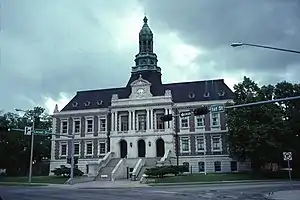 Hall County Courthouse in Grand Island | |
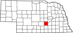 Location within the U.S. state of Nebraska | |
 Nebraska's location within the U.S. | |
| Coordinates: 40°52′N 98°30′W | |
| Country | |
| State | |
| Founded | 1858 |
| Named for | Augustus Hall |
| Seat | Grand Island |
| Largest city | Grand Island |
| Area | |
| • Total | 552 sq mi (1,430 km2) |
| • Land | 546 sq mi (1,410 km2) |
| • Water | 5.9 sq mi (15 km2) 1.1%% |
| Population | |
| • Estimate (2018) | 61,607 |
| • Density | 112.7/sq mi (43.5/km2) |
| Time zone | UTC−6 (Central) |
| • Summer (DST) | UTC−5 (CDT) |
| Congressional district | 3rd |
| Website | www |
Hall County is part of the Grand Island, NE Metropolitan Statistical Area.
In the Nebraska license plate system, Hall County is represented by the prefix 8. Hall County had the eighth-largest number of vehicles registered in the county when the license plate system was established in 1922.
Geography
The Platte River flows northeastward across the lower portion of Hall County; the South Loup River flows northeastward across the NW corner of the county; both flowing to their eventual drainage into the Missouri River.
According to the US Census Bureau, the county has a total area of 552 square miles (1,430 km2), of which 546 square miles (1,410 km2) is land and 5.9 square miles (15 km2) (1.1%) is water.[4]
Hall County has the highest density of tornado activity in Nebraska, with 121 tornadoes per 1,000 square miles (2,600 km2), about 4 times the state average.
Major highways
Adjacent counties
- Merrick County – northeast
- Hamilton County – east
- Adams County – south
- Kearney County – southwest
- Howard County – north
- Buffalo County – west
Protected areas
- Cheyenne State Recreation Area[5]
- Cornhusker State Wildlife Management Area[6]
- Denman Island State Wildlife Management Area (part)[7]
- Hannon Federal Waterfowl Production Area[8]
- Loch Linda State Wildlife Management Area[9]
- Martins Reach State Wildlife Management Area[10]
- Mormon Island State Recreation Area[11]
- Wood River West State Wildlife Management Area[12]
Demographics
| Historical population | |||
|---|---|---|---|
| Census | Pop. | %± | |
| 1860 | 116 | — | |
| 1870 | 1,057 | 811.2% | |
| 1880 | 8,572 | 711.0% | |
| 1890 | 16,513 | 92.6% | |
| 1900 | 17,206 | 4.2% | |
| 1910 | 20,361 | 18.3% | |
| 1920 | 23,720 | 16.5% | |
| 1930 | 27,117 | 14.3% | |
| 1940 | 27,523 | 1.5% | |
| 1950 | 32,186 | 16.9% | |
| 1960 | 35,757 | 11.1% | |
| 1970 | 42,851 | 19.8% | |
| 1980 | 47,690 | 11.3% | |
| 1990 | 48,925 | 2.6% | |
| 2000 | 53,534 | 9.4% | |
| 2010 | 58,607 | 9.5% | |
| 2018 (est.) | 61,607 | [13] | 5.1% |
| US Decennial Census[14] 1790-1960[15] 1900-1990[16] 1990-2000[17] 2010-2013[1] | |||
As of the 2000 United States Census,[18] there were 53,534 people, 20,356 households, and 14,086 families in the county. The population density was 98 people per square mile (38/km2). There were 21,574 housing units at an average density of 40 per square mile (15/km2). The racial makeup of the county was 88.67% White, 0.36% Black or African American, 0.31% Native American, 1.09% Asian, 0.14% Pacific Islander, 8.19% from other races, and 1.24% from two or more races. 14.00% of the population were Hispanic or Latino of any race.
There were 20,356 households, out of which 34.80% had children under the age of 18 living with them, 55.90% were married couples living together, 9.70% had a female householder with no husband present, and 30.80% were non-families. 25.50% of all households were made up of individuals, and 10.50% had someone living alone who was 65 years of age or older. The average household size was 2.57 and the average family size was 3.08.
The county population contained 27.20% under the age of 18, 8.90% from 18 to 24, 28.30% from 25 to 44, 21.70% from 45 to 64, and 14.00% who were 65 years of age or older. The median age was 36 years. For every 100 females, there were 98.40 males. For every 100 females age 18 and over, there were 96.20 males.
The median income for a household in the county was $36,972, and the median income for a family was $43,963. Males had a median income of $29,158 versus $20,576 for females. The per capita income for the county was $17,386. 12.00% of the population and 9.20% of families were below the poverty line. Out of the total population, 15.50% of those under the age of 18 and 8.30% of those 65 and older were living below the poverty line.
Communities
- Abbott
- Alda
- Cairo
- Cameron[19]
- Doniphan
- Grand Island (county seat)
- Hansen
- Shelton
- Wood River
Politics
Hall County has been a Republican Party stronghold for most of its history at the presidential level. In only four presidential elections from 1900 to the present has a Democratic Party candidate carried the county, the most recent being Lyndon B. Johnson in 1964.
| Year | Republican | Democratic | Third Parties |
|---|---|---|---|
| 2020 | 66.2% 16,189 | 31.4% 7,681 | 2.4% 580 |
| 2016 | 65.3% 14,408 | 28.5% 6,282 | 6.2% 1,370 |
| 2012 | 62.5% 12,646 | 35.4% 7,161 | 2.1% 422 |
| 2008 | 61.0% 12,977 | 36.9% 7,855 | 2.1% 439 |
| 2004 | 69.0% 14,592 | 29.4% 6,228 | 1.6% 334 |
| 2000 | 63.6% 11,803 | 32.1% 5,952 | 4.3% 791 |
| 1996 | 52.5% 10,183 | 34.6% 6,708 | 13.0% 2,525 |
| 1992 | 44.7% 9,341 | 26.6% 5,558 | 28.8% 6,014 |
| 1988 | 63.4% 12,062 | 36.0% 6,853 | 0.6% 108 |
| 1984 | 73.5% 13,193 | 25.9% 4,655 | 0.6% 108 |
| 1980 | 68.1% 12,166 | 24.8% 4,422 | 7.1% 1,269 |
| 1976 | 62.9% 10,935 | 35.0% 6,079 | 2.1% 372 |
| 1972 | 72.3% 10,987 | 27.7% 4,218 | |
| 1968 | 61.0% 8,457 | 33.0% 4,571 | 6.0% 833 |
| 1964 | 44.8% 6,715 | 55.2% 8,273 | |
| 1960 | 64.0% 9,763 | 36.0% 5,496 | |
| 1956 | 66.5% 9,536 | 33.6% 4,815 | |
| 1952 | 69.4% 10,435 | 30.6% 4,608 | |
| 1948 | 55.4% 5,694 | 44.6% 4,590 | |
| 1944 | 61.6% 7,651 | 38.4% 4,768 | |
| 1940 | 61.3% 7,412 | 38.7% 4,687 | |
| 1936 | 43.6% 5,146 | 53.3% 6,295 | 3.1% 369 |
| 1932 | 35.7% 3,743 | 59.7% 6,266 | 4.6% 483 |
| 1928 | 66.6% 6,862 | 32.9% 3,391 | 0.5% 53 |
| 1924 | 47.4% 4,040 | 21.9% 1,863 | 30.8% 2,622 |
| 1920 | 66.3% 4,719 | 24.2% 1,724 | 9.6% 680 |
| 1916 | 48.5% 2,555 | 47.2% 2,483 | 4.3% 226 |
| 1912 | 23.7% 1,047 | 47.3% 2,085 | 29.0% 1,280 |
| 1908 | 47.9% 2,241 | 47.6% 2,229 | 4.5% 211 |
| 1904 | 65.7% 2,508 | 21.4% 817 | 12.9% 493 |
| 1900 | 52.2% 2,017 | 45.7% 1,766 | 2.2% 85 |
References
- "State & County QuickFacts". US Census Bureau. Archived from the original on June 7, 2011. Retrieved September 20, 2013.
- "Find a County". National Association of Counties. Retrieved 7 June 2011.
- Gannett, Henry (1905). The Origin of Certain Place Names in the United States. Govt. Print. Off. p. 147.
- "2010 Census Gazetteer Files". US Census Bureau. August 22, 2012. Archived from the original on November 13, 2013. Retrieved December 8, 2014.
- Cheyenne State Recreation Area, Wood River NE Google Maps (accessed 21 January 2019)
- Cornhusker State Wildlife Management Area, Grand Island NE Google Maps (accessed 21 January 2019)
- Denman Island State Wildlife Management Area, Wood River NE Google Maps (accessed 21 January 2019)
- Hannon Federal Waterfowl Production Area, Wood River NE Google Maps (accessed 21 January 2019)
- Loch Linda State Wildlife Management Area, Grand Island NE Google Maps (accessed 21 January 2019)
- Martins Reach State Wildlife Management Area, Wood River NE Google Maps (accessed 21 January 2019)
- Mormon Island State Recreation Area Google Maps (accessed 21 January 2019)
- Wood River West State Wildlife Management Area, Wood River NE Google Maps (accessed 21 January 2019)
- "Population and Housing Unit Estimates". Retrieved December 23, 2019.
- "US Decennial Census". US Census Bureau. Retrieved December 8, 2014.
- "Historical Census Browser". University of Virginia Library. Retrieved December 8, 2014.
- "Population of Counties by Decennial Census: 1900 to 1990". US Census Bureau. Retrieved December 8, 2014.
- "Census 2000 PHC-T-4. Ranking Tables for Counties: 1990 and 2000" (PDF). US Census Bureau. Retrieved December 8, 2014.
- "U.S. Census website". US Census Bureau. Retrieved 31 January 2008.
- Cameron NE Google Maps (accessed 21 January 2019)
- Election Results
External links
Places adjacent to Hall County, Nebraska | ||||||||||
|---|---|---|---|---|---|---|---|---|---|---|
| ||||||||||
Municipalities and communities of Hall County, Nebraska, United States | ||
|---|---|---|
| Cities | Map of Nebraska highlighting Hall County | |
| Villages | ||
| Townships |
| |
| Unincorporated communities | ||
| Footnotes | ‡This populated place also has portions in an adjacent county or counties | |
| ||

| Authority control |
|---|