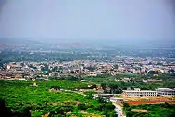
Nowshera, Khyber Pakhtunkhwa
Nowshera (Urdu: نوشہرہ ![]() pronunciation ; Pashto: نوښار, pr. Nowkhār
pronunciation ; Pashto: نوښار, pr. Nowkhār ![]() pronunciation ) is the capital city of Nowshera District in the Khyber Pakhtunkhwa province of Pakistan. It is the 78th largest city in Pakistan and ninth largest city in the province of Khyber Pakhtunkhwa.
pronunciation ) is the capital city of Nowshera District in the Khyber Pakhtunkhwa province of Pakistan. It is the 78th largest city in Pakistan and ninth largest city in the province of Khyber Pakhtunkhwa.
Nowshera
| |
|---|---|
 | |
 Nowshera  Nowshera | |
| Coordinates: 34°0′55″N 71°58′29″E | |
| Country | |
| Province | |
| District | Nowshera |
| Tehsil | Nowshera |
| Government | |
| • District Nazim | Liaquat Khattak |
| Area | |
| • Total | 1,748 km2 (675 sq mi) |
| Population | |
| • Total | 120,131 |
| • Density | 500/km2 (1,000/sq mi) |
| Nowshera Kalan Municipal Committee: 83,567 Nowshera Cantonment: 36,564 | |
| Time zone | UTC+5 (PST) |
| Area code(s) | 0923 |
| Highways | |
Located in the Valley of Peshawar, Nowshera lies on the Kabul River, and is approximately 27 miles (43 km) east of the provincial capital Peshawar, along the historic Grand Trunk Road.[3]
Etymology
The local Pashto name of the city is Nowkhār (نوښار), which means "New City". It was translated into Dari Persian and Urdu as Nowshehra (نوشہرہ), which is a word with the same meaning.
History
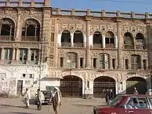
Nowshera was developed during the Afghan Durrani Empire. The Battle of Nowshera was fought in March 1823 between the forces of Pashtuns with support from Azim Khan Barakzai, Durrani governor against the Sikh Khalsa Army of Ranjit Singh.[4] The battle was a decisive victory for the Sikh Empire against Afghans and led to their occupation of the Peshawar Valley.[5]
During British rule, Nowshera was a town and cantonment as well as tehsil of the Peshawar District (later Peshawar Division). The town was on the route of the North-Western Railway and Grand Trunk Road. The population according to the 1901 census of India was 9,518.
The Imperial Gazetteer of India described the cantonment as follows:[3]
The cantonment stretches along the right bank of the Kābul river on a sandy plain, 3 miles in diameter, and is surrounded by low hills on all sides except the north, which is open towards the river. The garrison now consists of one British infantry regiment, two Native cavalry and four infantry regiments, a mountain battery, and a bearer corps, belonging to the Peshāwar division of the Northern Command. The Kābul river is crossed by a permanent bridge of boats, whence roads lead to Mardān and Chārsadda. The iron road and railway bridge across the river was opened on December 1, 1903. The village of Naushahra Khurd, west of the cantonment, and the large village of Naushahra Kalān, on the north bank of the Kābul, are both outside cantonment limits. The headquarters of the Naushahra tahsīl, with the police station, are in the former, 3 miles from the cantonment. The town contains a Government dispensary and a vernacular middle school, maintained by the District board.
Geography
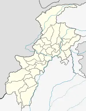
Nowshera District is bordered by Peshawar District to the west, Mardan District to the north, Charsadda District to the northwest, Swabi District to the northeast, Kohat District to the south, Orakzai Agency to the southwest, and Attock District to the east.
Generally, winters are cold from November to February, and summers are hot from June to August.
Demography
Pashto is the native language of the majority of residents. Hindko is also spoken in the city and parts of surrounding villages. Urdu, being the national language of Pakistan, is also widely understood.
According to the 1998 census of Pakistan the population was 874,373. The male population was 455,598 (52.10%), while the female population was 418,775 (47.90%), a population density of 500.2 persons per km².[6] The population of Urban dwellers was 227030 (25.96%) and that of Rural dwellers was 647343 (74.04%).[6] The annual growth rate was 2.9%.[6] The literacy rate was 89%.[6]
Transportation
Nowshera is well connected with the rest of the Khyber Pakhtunkhwa province and other provinces of Pakistan through airports, railways, and roads.
Air
Bacha Khan International Airport in Peshawar and Islamabad International Airport in Islamabad are situated at a drive of around 1 hour and 2 hours, respectively.
Rail
Pakistan Railways offers passengers and freight rail services. Kabul River railway station and Nowshera Junction railway station are in the city.
Road
National Highway 5, or N-5, is Pakistan’s longest highway running from the port city of Karachi to the border crossing at Torkham. Its total length is 1,756 km and it runs north from Karachi located in Sindh province to Hyderabad, Moro and Khairpur before crossing into Punjab province where it passes through Multan, Sahiwal, Lahore, Sheikhupura District, Gujranwala, Gujrat, Jhelum and Rawalpindi. At Rawalpindi, it turns eastwards and passes through Attock Khurd before crossing the Indus River into Khyber Pakhtunkhwa to continue through Nowshera and Peshawar before entering the Khyber Pass and reaching the border town of Torkham.
The M-1 motorway in Punjab and Khyber-Pakhtunkhwa, Pakistan. It is 155 km long, with 67 km in Punjab and the remaining 88 km in Khyber-Pakhtunkhwa. It has become a vital link to Afghanistan and Central Asia and is expected to take much traffic off the highly used N5. It is part of Pakistan’s Motorway Network. M1 begins northeast of Peshawar as it moves in an eastern direction, crossing over the Kabul River. From here it passes through Charsadda, Risalpur, Swabi and Rashakai before crossing the Indus River.
The historical Grand Trunk (GT) Road also passes through Nowshera. Swat Expressway also starts nearby Nowshera and ends at near Swat.
Economic Zone
After the launch of CPEC project, Rashakai village of Nowshera is now an Economic Zone of KPK.[7]
Administrative units
References
- "Archived copy". Archived from the original on 2016-05-08. Retrieved 2016-06-11.CS1 maint: archived copy as title (link)
- "POPULATION AND HOUSEHOLD DETAIL FROM BLOCK TO DISTRICT LEVEL: KHYBER PAKHTUNKHWA (NOWSHERA DISTRICT)" (PDF). 2018-01-03. Archived from the original (PDF) on 2018-04-24. Retrieved 2018-04-25.
- "Imperial Gazetteer2 of India, Volume 18, page 417 -- Imperial Gazetteer of India -- Digital South Asia Library". dsal.uchicago.edu.
- Ganda Singh (1986) Maharaja Ranjit Singh: First Death Centenary Memorial. Nirmal Publishers
- Joseph Greenwood (1844) Narrative of the late Victorious Campaigns in Afghanistan: under General Pollock; with recollections of seven years' service in India. London: H. Colburn.
- "District At a Glance-Nowshera". Pakistan Bureau of Statistics. Government of Pakistan. Retrieved 28 June 2016.
- "Rashakai Tech City - A Special Economic Zone - CPEC". Rashakai Tech City. Retrieved 2017-08-09.
- "District At A Glance Nowshera". Pakistan Bureau of Statistics. Retrieved 28 June 2016.