Balochistan, Pakistan
Balochistan (/bəˌloʊtʃɪˈstɑːn/; Urdu: بلوچِستان) is one of the four provinces of Pakistan. It is the largest province in terms of land area, forming the southwestern region of the country, but is the least populated. Its provincial capital and largest city is Quetta.
Balochistan
بلوچستان | |
|---|---|
    | |
 Flag  Seal | |
.svg.png.webp) Location of Balochistan in Pakistan | |
| Coordinates: 27.7°N 65.7°E | |
| Country | |
| Established | 1 July 1970 |
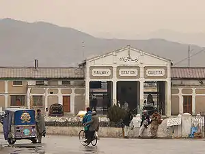
| Provincial Capital | Quetta |
| Largest city | Quetta |
| Government | |
| • Type | Self-governing Province subject to the Federal Government |
| • Body | Government of Balochistan |
| • Governor | Amanullah Khan Yasinzai,[1] (PTI) |
| • Chief Minister | Jam Kamal Khan, (BAP) |
| • Chief Secretary | Akhtar Nazir |
| • Legislature | Provincial Assembly |
| • High Court | Balochistan High Court |
| Area | |
| • Total | 347,190 km2 (134,050 sq mi) |
| Area rank | 1st |
| Population | |
| • Total | 12,344,408 |
| • Rank | 4th |
| • Density | 36/km2 (92/sq mi) |
| Demonym(s) | Baloch |
| Time zone | UTC+05:00 (PST) |
| ISO 3166 code | PK-BA |
| Main Language(s) | |
| Notable sports teams | Quetta Gladiators Quetta Bears |
| HDI (2018) | 0.477 Low |
| Seats in National Assembly | 30 |
| Seats in Provincial Assembly | 65 |
| Divisions | 7 |
| Districts | 33 |
| Tehsils | 134 |
| Union Councils | 86 |
| Website | www |
Balochistan shares borders with Punjab and the Khyber Pakhtunkhwa to the northeast, Sindh to the east and southeast, the Arabian Sea to the south, Iran to the west and Afghanistan to the north and northwest.
The main ethnic groups in the province are the Baloch people and the Pashtuns, who constitute 52% and 36% of the population respectively (according to the preliminary 2011 census).[5] The remaining 12% comprises smaller communities of Brahuis, Hazaras along with other settlers such as Sindhis, Punjabis, Uzbeks and Turkmens. The name "Balochistan" means "the land of the Baloch". Largely underdeveloped, its provincial economy is dominated by natural resources, especially its natural gas fields, estimated to have sufficient capacity to supply Pakistan's demands over the medium to long term. Aside from Quetta, the second-largest city of the province is Turbat in the south, while another area of major economic importance is Gwadar Port on the Arabian Sea.
Balochistan is noted for its unique culture and extremely dry desert climate.[6]
History
Early history
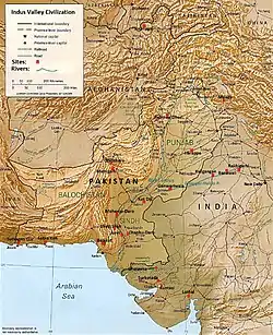
Balochistan occupies the very southeasternmost portion of the Iranian Plateau, the setting for the earliest known farming settlements in the pre-Indus Valley Civilisation era, the earliest of which was Mehrgarh, dated at 7000 BC, within the province. Balochistan marked the westernmost extent of the Civilisation. Centuries before the arrival of Islam in the 7th Century, parts of Balochistan was ruled by the Paratarajas, an Indo-Scythian dynasty. At certain times, the Kushans also held political sway in parts of Balochistan.
The Hindu Sewa Dynasty ruled parts of Balochistan, chiefly Kalat.[7][8] The Sibi Division, which was carved out of Quetta Division and Kalat Division in 1974, derives its name from Rani Sewi, the queen of the Sewa dynasty.[9]
A theory of the origin of the Baloch people, the largest ethnic group in the region, is that they are of Median descent.[10]
Arrival of Islam
In 654, Abdulrehman ibn Samrah, governor of Sistan and the newly emerged Rashidun caliphate at the expense of Sassanid Persia and the Byzantine Empire, sent an Islamic army to crush a revolt in Zaranj, which is now in southern Afghanistan. After conquering Zaranj, a column of the army pushed north, conquering Kabul and Ghazni, in the Hindu Kush mountain range, while another column moved through Quetta District in north-western Balochistan and conquered the area up to the ancient cities of Dawar and Qandabil (Bolan).[11] It is documented that the major settlements, falling within today's province, became in 654 controlled by the Rashidun caliphate, except for the well-defended mountain town of QaiQan which is now Kalat.
During the caliphate of Ali, a revolt broke out in southern Balochistan's Makran region.[12] In 663, during the reign of Umayyad Caliph Muawiyah I, his Muslim rule lost control of north-eastern Balochistan and Kalat when Haris ibn Marah and a large part of his army died in battle against a revolt in Kalat.[13]
Pre-modern era
In the 15th century, Mir Chakar Khan Rind became the first Sirdar of Afghani, Irani and Pakistani Balochistan. He was a close aide of the Timurid ruler Humayun, and was succeeded by the Khanate of Kalat, which owed allegiance to the Mughal Empire. Later, Nader Shah won the allegiance of the rulers of eastern Balochistan. He ceded Kalhora, one of the Sindh territories of Sibi-Kachi, to the Khanate of Kalat.[14][15][16] Ahmad Shah Durrani, founder of the Afghan Empire, also won the allegiance of that area's rulers, and many Baloch fought under him during the Third Battle of Panipat. Most of the area would eventually revert to local Baloch control after Afghan rule.
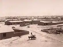
British Indian era
In the 1870s, Baluchistan came under control of the British Indian Empire in colonial India.[17] During this time from the fall of the Durrani Empire in 1823, four princely states were recognised and reinforced in Balochistan: Makran, Kharan, Las Bela and Kalat. In 1876, Robert Sandeman negotiated the Treaty of Kalat, which brought the Khan's territories, including Kharan, Makran, and Las Bela, under British protection even though they remained independent princely states.[18] After the Second Afghan War was ended by the Treaty of Gandamak in May 1879, the Afghan Emir ceded the districts of Quetta, Pishin, Harnai, Sibi and Thal Chotiali to British control. On 1 April 1883, the British took control of the Bolan Pass, south-east of Quetta, from the Khan of Kalat. In 1887, small additional areas of Balochistan were declared British territory.[19] In 1893, Sir Mortimer Durand negotiated an agreement with the Amir of Afghanistan, Abdur Rahman Khan, to fix the Durand Line running from Chitral to Balochistan as the boundary between the Emirate of Afghanistan and British-controlled areas. Two devastating earthquakes occurred in Balochistan during British colonial rule: the 1935 Quetta earthquake, which devastated Quetta, and the 1945 Balochistan earthquake with its epicentre in the Makran region.[20] During the time of the Indian independence movement, "three pro-Congress parties were still active in Balochistan's politics", such as the Anjuman-i-Watan Baluchistan, which favoured a united India and opposed its partition.[21][22]
After independence
Balochistan contained a Chief Commissioner's province and four princely states under the British Raj in colonial India. The province's Shahi Jirga and the non-official members of the Quetta Municipality opted for Pakistan unanimously on 29 June 1947.[23] Three of the princely states, Makran, Las Bela and Kharan, acceded to Pakistan in 1947 after independence.[24] But the ruler of the fourth princely state, the Khan of Kalat, Ahmad Yar Khan, who used to call Jinnah his 'father',[25] declared Kalat's independence as this was one of the options given to all of the 565 princely states by British Prime Minister Clement Attlee.[26]
Kalat finally acceded to Pakistan on 27 March 1948 after period of negotiations with Pakistan.[25] The signing of the Instrument of Accession by Ahmad Yar Khan, led his brother, Prince Abdul Karim, to revolt against his brother's decision due to their family rift.[27] in July 1948.[28] Princes Agha Abdul Karim Baloch and Muhammad Rahim, refused to lay down arms, leading the Dosht-e Jhalawan in unconventional attacks on the army until 1950.[27] The Prince indulged in Terror activities without any assistance from others.[29] Jinnah and his successors allowed Yar Khan to retain his title until the province's dissolution in 1955.
Insurgencies by Baloch nationalists took place in 1948, 1958–59, 1962–63 and 1973–77 – with a new ongoing insurgency by autonomy-seeking Baloch groups since 2003.[30][31] While a few Baloch support the demand for autonomy, the majority are not interested in seceding from Pakistan.[32]
At a press conference on 8 June 2015 in Quetta, Balochistan's Home Minister Sarfraz Bugti accused India's prime minister Narendra Modi of openly supporting terrorism. Bugti implicated India's Research and Analysis Wing (RAW) of being responsible for recent attacks at military bases in Smangli and Khalid, and for subverting the China–Pakistan Economic Corridor (CPEC) agreement.[33][34][35]
Geography
Balochistan is situated in the southwest of Pakistan and covers an area of 347,190 square kilometres (134,050 sq mi). It is Pakistan's largest province by area, constituting 44% of Pakistan's total land mass. The province is bordered by Afghanistan to the north and north-west, Iran to the south-west, Punjab and Sindh, and Khyber Pakhtunkhwa and the Federally Administered Tribal Areas to the north-east. To the south lies the Arabian Sea. Balochistan is located on the south-eastern part of the Iranian plateau. It borders the geopolitical regions of the Middle East and Southwest Asia, Central Asia and South Asia. Balochistan lies at the mouth of the Strait of Hormuz and provides the shortest route from seaports to Central Asia. Its geographical location has placed the otherwise desolate region in the scope of competing for global interests for all of recorded history.
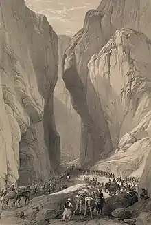
The capital city Quetta is located in a densely populated portion of the Sulaiman Mountains in the north-east of the province. It is situated in a river valley near the Bolan Pass, which has been used as the route of choice from the coast to Central Asia, entering through Afghanistan's Kandahar region. The British and other historic empires have crossed the region to invade Afghanistan by this route.[36]
Balochistan is rich in exhaustible and renewable resources; it is the second major supplier of natural gas in Pakistan. The province's renewable and human resource potential has not been systematically measured or exploited due to pressures from within and without Pakistan. Local inhabitants have chosen to live in towns and have relied on sustainable water sources for thousands of years.
Climate
The climate of the upper highlands is characterised by very cold winters and hot summers. In the lower highlands, winters vary from extremely cold in northern districts Ziarat, Quetta, Kalat, Muslim Baagh and Khanozai to milder conditions closer to the Makran coast. Winters are mild on the plains, with temperature never falling below freezing point. Summers are hot and dry, especially in the arid zones of Chagai and Kharan districts. The plains are also very hot in summer, with temperatures reaching 50 °C (122 °F). The record highest temperature, 53 °C (127 °F), was recorded in Sibi on 26 May 2010,[37] exceeding the previous record, 52 °C (126 °F). Other hot areas include Turbat and Dalbandin. The desert climate is characterised by hot and very arid conditions. Occasionally, strong windstorms make these areas very inhospitable.
Education
Schools
Medical colleges
- Bolan University of Medical & Health Sciences
- Makran Medical College
- Loralai Medical College
- Jhalawan Medical College, Khuzdar
- Quetta Institute of Medical Sciences
General Colleges
- Balochistan Agriculture College
- Balochistan Institute of Technology
- Zarghoon Law College
- Islamia College
- FG Boys Degree College Quetta Cantt
- Fazaia Inter College
Engineering universities
- Balochistan University of Engineering and Technology, Khuzdar
- Balochistan University of Information Technology, Engineering and Management Sciences, Quetta
Economy
The economy of Balochistan is largely based upon the production of natural gas, coal and other minerals.[38]
Balochistan has been called a "neglected province where a majority of population lacks amenities".[39][40] Since the mid-1970s the province's share of Pakistan's GDP has dropped from 4.9 to 3.7%,[41] and as of 2007 it had the highest poverty rate and infant and maternal mortality rate, and the lowest literacy rate in the country,[42] factors some allege have contributed to the insurgency.[40] However, in 7th NFC awards, Punjab province and Federal contributed to increase Baluchistan share more than its entitled population based share.[43] In Balochistan poverty is increasing. In 2001–2002 poverty incidences were at 48% and by 2005–2006 these were at 50.9%.[44] According to a report on Dawn, the rate of multidimensional poverty in Balochistan had risen to 71% by 2016.[45]
Though the province remains largely underdeveloped, several major development projects, including the construction of a new deep sea port at the strategically important town of Gwadar,[46] are in progress in Balochistan. The port is projected to be the hub of an energy and trade corridor to and from China and the Central Asian republics. The Mirani Dam on the Dasht River, 50 kilometres (31 mi) west of Turbat in the Makran Division, is being built to provide water to expand agricultural land use by 35,000 km2 (14,000 sq mi) where it would otherwise be unsustainable.[47] In the district Lasbela, there is an oil refinery owned by Byco International Incorporated (BII), which is capable of processing 120,000 barrels of oil per day. A power station is located adjacent to the refinery.[48] Several cement plants and a marble factory are also located there.[49][50][51] One of the world's largest ship breaking yards is located on the coast.[52]
Natural resource extraction
Balochistan's share of Pakistan's national income has historically ranged between 3.7% to 4.9%.[53] Since 1972, Balochistan's gross income has grown in size by 2.7 times.[54] Outside Quetta, the resource extraction infrastructure of the province is gradually developing but still lags far behind other parts of Pakistan.
The agreements for royalty rights and ownership of mineral rights were reached during a period of unprecedented natural disasters, economic, social, political, and cultural unrest in Pakistan. The negotiations were widely considered to be insufficiently transparent.[55]
Tourism
Balochistan has much tourist potential, though the province has seen little of it. There are many tourism-worthy sites and places within the province. Tourism in Balochistan sharply declined after the 9/11 terror attacks due to terrorism. However, recently, tourism is growing in Balochistan and fights against terrorists have proved successful. The China-Pakistan Economic Corridor (CPEC) also aims to revive the growing tourism industry by improving road networks which would generate jobs and income for the Baloch people as well as help Pakistan in improving its GDP.
Places of Interest
Following is a list of a few tourist attraction and places of interest in Balochistan:
- Hazarganji Chiltan National Park, near Quetta, Balochistan.
- The Sphinx of Balochistan.
- The princess of hope, Balochistan
- Pir ghaib waterfall, Balochistan
- Astola Island
- Bolan Pass
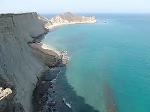
- Makran Coastal Highway
- Gwadar
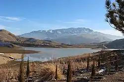
- Hanna Lake
- Hingol National Park
- Jiwani Coastal Wetland
- Khuzdar
- Kund Malir
- Quetta
- Mehrgarh
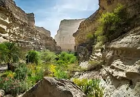
- Moola Chotok
- Urak Valley
- Ziarat
- Ziarat Juniper Forest
- Hinglaj Mata Temples
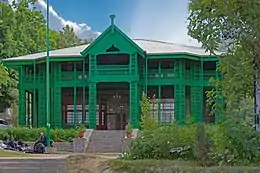
- Quaid-e-Azam Residency
Government and politics
In common with the other provinces of Pakistan, Balochistan has a parliamentary form of government. The ceremonial head of the province is the Governor, who is appointed by the President of Pakistan on the advice of the provincial Chief Minister. The Chief Minister, the province's chief executive, is normally the leader of the largest political party or alliance of parties in the provincial assembly.
The unicameral Provincial Assembly of Balochistan comprises 65 seats of which 11 are reserved for women and 3 reserved for non-Muslims. The judicial branch of government is carried out by the Balochistan High Court, which is based in Quetta and headed by a Chief Justice.
Besides dominant Pakistan-wide political parties (such as the Pakistan Muslim League (N) and the Pakistan Peoples Party), Balochistan nationalist parties (such as the National Party and the Balochistan National Party (Mengal)) have been prominent in the province.[30]
Administration
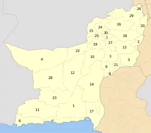
For administrative purposes, the province is divided into six divisions – Kalat, Makran, Nasirabad, Quetta, Sibi and Zhob. This divisional level was abolished in 2000, but restored after the 2008 election. Each division is under an appointed commissioner. The six divisions are further subdivided into 34 districts:[56]
| Sr. no. | District | Headquarters | Area (km2) |
Population (2017)[57] |
Density (people/km2) |
Division |
|---|---|---|---|---|---|---|
| 1 | Awaran | Awaran | 12,510 | 121,680 | 4 | Kalat |
| 2 | Barkhan | Barkhan | 3,514 | 171,556 | 29 | Zhob |
| 3 | Kachhi (Bolan) | Dhadar | 7,499 | 237,030 | 38 | Nasirabad |
| 4 | Chagai | Chagai | 44,748[58] | 300,000 | 7 | Quetta |
| 5 | Dera Bugti | Dera Bugti | 10,160 | 181,310 | 18 | Sibi |
| 6 | Gwadar | Gwadar | 12,637 | 263,514 | 15 | Makran |
| 7 | Harnai[59][note 1] | Harnai | -- | 97,017 | -- | Sibi |
| 8 | Jafarabad | Dera Allahyar | 2,445 | 513,813 | 177 | Nasirabad |
| 9 | Jhal Magsi | Jhal Magsi | 3,615 | 149,225 | 30 | Nasirabad |
| 10 | Kalat | Kalat | 6,622 | 412,232 | 36 | Kalat |
| 11 | Kech (Turbat) | Turbat | 22,539 | 909,116 | 18 | Makran |
| 12 | Kharan | Kharan | 18,958 | 156,152 | 4 | Kalat |
| 13 | Kohlu | Kohlu | 7,610 | 214,350 | 13 | Sibi |
| 14 | Khuzdar | Khuzdar | 35,380 | 802,207 | 12 | Kalat |
| 15 | Killa Abdullah | Chaman | 3,293 | 757,578 | 112 | Quetta |
| 16 | Killa Saifullah | Killa Saifullah | 6,831 | 342,814 | 28 | Zhob |
| 17 | Lasbela | Uthal | 15,153 | 574,292 | 21 | Kalat |
| 18 | Loralai | Loralai | 9,830 | 397,4001 | 30 | Zhob |
| 19 | Mastung | Mastung | 5,896 | 266,461 | 30 | Kalat |
| 20 | Musakhel | Musa Khel Bazar | 5,728 | 167,017 | 23 | Zhob |
| 21 | Nasirabad | Dera Murad Jamali | 3,387 | 490,538 | 73 | Nasirabad |
| 22 | Nushki[60] | Nushki | 5,797 | 178,796 | 23 | Quetta |
| 23 | Panjgur | Panjgur | 16,891 | 316,385 | 14 | Makran |
| 24 | Pishin | Pishin | 7,819 | 736,481 | 47 | Quetta |
| 25 | Quetta | Quetta | 2,653 | 2,275,699 | 281 | Quetta |
| 26 | Sherani[note 2] | Sherani | -- | 153,116 | -- | Zhob |
| 27 | Sibi | Sibi | 7,796 | 135,572 | 23 | Sibi |
| 28 | Washuk[note 3] | Washuk | 29,510 | 176,206 | 4.0 | Kalat |
| 29 | Zhob | Zhob | 20,297 | 275,142 | 14 | Zhob |
| 30 | Ziarat | Ziarat | 1,489 | 33,340 | 22 | Sibi |
| 31 | Lehri[note 4] | Bakhtiarabad | -- | 118,046 | -- | Sibi |
| 32 | Sohbatpur[note 5] | Sohbatpur | -- | 200,538 | -- | Nasirabad |
| 33 | Shaheed Sikandarabad[note 6] | Surab | -- | 180,398 | -- | Kalat |
| 34 | Duki[note 7] | Duki | -- | 153,000 | -- | Zhob |
Demographics
| Historical populations | ||
|---|---|---|
| Census | Population | Urban |
|
| ||
| 1951 | 1,167,167 | 12.38% |
| 1961 | 1,353,484 | 16.87% |
| 1972 | 2,428,678 | 16.45% |
| 1981 | 4,332,376 | 15.62% |
| 1998 | 6,565,885 | 23.89% |
| 2017 | 12,344,408 | 27.55% |
Balochistan's population density is low due to the mountainous terrain and scarcity of water. In March 2012, preliminary census figures showed that the population of Balochistan had reached 13,162,222, not including the districts of Khuzdar, Kech and Panjgur, a 139.3% increase from 5,501,164 in 1998, representing 6.85% of Pakistan's total population. This was the largest increase in population by any province of Pakistan during that time period.[3][61][62] Official estimates of Balochistan's population grew from approximately 7.45 million in 2003 to 7.8 million in 2005.[63] The 2017 Census enumerated a population of 12,344,408.
Ethnolinguistic groups
In the 1998 census the Balochi was the main language of Balochistan spoken by 54.8%, Pashto was spoken by 29.6%, Sindhi by 5.6%, Punjabi by 2.5%, Saraiki by 2.4%, Urdu by 1% and Others 4.1%.[65]
According to the Ethnologue, households speaking Balochi, whose primary dialect is Makrani constitutes 13%, Rukhshani 10%, Sulemani 7%, and Khetrani 3% of the population. Other languages spoken are Lasi, Urdu, Punjabi, Hazargi, Sindhi, Saraiki, Dehvari, Dari, Tajik, Hindko, Uzbek, and Hindki.[65] In the Lasbela District, the majority of the population speaks Lasi,[66] which is a dialect of Sindhi.[67]
Balochi forms majority in 21 districts and Pashtun forms majority in 9 districts of Balochistan.[68]
The 2005 census concerning Afghans in Pakistan showed that a total of 769,268[69] Afghan refugees were temporarily staying in Balochistan. However, there are probably fewer Afghans living in Balochistan today as many refugees repatriated in 2013. As of 2015, there are only 327,778 registered Afghan refugees according to the UNHCR.[70]
Religion
According to the 1998 Census, Balochistan had a total population of 6,565,885 of which most (6,484,006) were Muslims. There were also Hindu and Christian minorities in the province. The Hindu population in the province was approximately 39,000 (including the Scheduled Castes).[71] The Shri Hinglaj Mata mandir which is the largest Hindu pilgrimage centre in Pakistan is situated in Balochistan.[72] There was also a Christian minority of 26,462 individuals in the province.[71]
See also
Notes
- No data is yet available on the recently created district of Harnai, which was part of Sibi District.
- No data except population is available on the recently created district of Sherani, which was part of Zhob District.
- No data except population is available on the recently created district of Washuk, which was part of Kharan District.
- No data except population is available on the recently created district of Lehri, which was part of Sibi District.
- No data except population is available on the recently created district of Sohbatpur, which was part of Jaffarabad District.
- No data except population is available on the recently created district of Shaheed Sikandarabad, which was part of Kalat District.
- No data except population is available on the recently created district of Duki, which was part of Loralai District.
References
- Retired justice Amanullah Khan Yasinzai appointed Balochistan governor, The Express Tribune, 3 October 2018.
- "DISTRICT WISE CENSUS RESULTS CENSUS 2017" (PDF). pbscensus.gov.pk. Archived from the original (PDF) on 29 August 2017.
- "Pak population increased by 46.9% between 1998 and 2011". The Times of India. Archived from the original on 29 January 2016. Retrieved 27 January 2016.
- "Sub-national HDI - Area Database - Global Data Lab". hdi.globaldatalab.org. Retrieved 15 March 2020.
- Lakdawalla, Muhammad (5 April 2012). "The tricky demographics of Balochistan". Dawn News. Archived from the original on 25 November 2016. Retrieved 16 May 2017.
- "Balochistan | province, Pakistan". Encyclopedia Britannica. Archived from the original on 5 April 2017. Retrieved 5 April 2017.
- Fowle, T. C.; Rai, Diwan Jamiat (1923). Baluchistan. Directorate of Archives, Government of Balochistan. p. 100.
The Hindus of Kalat town may indeed be far more indigenous, since they claim descent from the ancient Sewa dynasty that ruled Kalat long before the Brahuis came to Baluchistan.
- Balochistan Through the Ages: Geography and history. Nisa Traders. 1979. p. 316.
The country up to and including Multan was conquered by the Arabs and the Hindu dynasty of Sind and probably also the Sewa dynasty of Kalat came to an end.
- Quddus, Syed Abdul (1990). The Tribal Baluchistan. Ferozsons. p. 49. ISBN 978-969-0-10047-4.
The Sibi division was carved out of the Quetta and Kalat Divisions in April, 1974, and comprises districts of Sibi, Kachhi, Nasirabad, Kohlu and Dera Bugti. The Division derives its name from the town of Sibi or Sewi. The local tradition attributes the origin of this name to Rani Sewi of the Sewa dynasty which ruled this part of the country in ancient times.
- M. Longworth Dames, Balochi Folklore, Folklore, Vol. 13, No. 3 (29 September 1902), pp. 252–274
- Tabqat ibn Saad, Vol. 8, p. 471
- Saxena, Sunil K. (2011). History of Medieval India. Pinnacle Technology.
- Tarikh al Khulfa, Vol. 1, pp. 214–215, 229
- urdukhabrain.pk
- Iranica.com
- "Ghulam Shah Kalhora and Relations With Kutch". Archived from the original on 19 February 2015. Retrieved 30 December 2014.
- Henige, David P. (1970). Colonial Governors from the Fifteenth Century to the Present: A Comprehensive List. University of Wisconsin Press. p. 89.
The British began to assume control over the rough desert region in extreme western India known as Baluchistan in the 1870s.
- Dashti, Naseer (2012). The Baloch and Balochistan: A Historical Account from the Beginning to the Fall of the Baloch State. Trafford Publishing. p. 247. ISBN 978-1-4669-5896-8.
- Peter R. Blood (1996). Pakistan: A Country Study. DIANE Publishing. p. 20.
- Foreign Affairs Pakistan, Volume 32, Issues 11–12. Ministry of Foreign Affairs. 2005. p. 257.
- Afzal, M. Rafique (2001). Pakistan: History and Politics 1947-1971. Oxford University Press. p. 40. ISBN 978-0-19-579634-6.
Besides the Balochistan Muslim League, three pro-Congress parties were still active in Balochistan's politics: the Anjuman-i Watan, the Jamiatul Ulama u Hind, and the Qalat State National Party.
- Ranjan, Amit (2018). Partition of India: Postcolonial Legacies. Taylor & Francis. ISBN 9780429750526.
Furthermore, Congress leadership of Balochistan was united and there was no disagreement over its president, Samad Khan Achakzai. On the other hand, Qazi Isa was the president of the League in Balochistan. Surprisingly, he was neither a Balochi nor a Sardar. Consequently, all Sardars except Jaffar Khan Jamali, were against Qazi Isa for contesting this seat.
- Pervaiz I Cheema; Manuel Riemer (22 August 1990). Pakistan's Defence Policy 1947–58. Palgrave Macmillan UK. pp. 60–. ISBN 978-1-349-20942-2.
- Hasnat 2011, p. 78.
- Yaqoob Khan Bangash (10 May 2015). "The princely India". The News on Sunday. Archived from the original on 25 December 2015. Retrieved 4 July 2017.
- Bennett Jones, Owen (2003). Pakistan: Eye of the storm (2nd Revised ed.). Yale University Press. p. 132. ISBN 978-0-300-10147-8.
- Qaiser Butt (22 April 2013). "Princely Liaisons: The Khan family controls politics in Kalat". The Express Tribune. Archived from the original on 22 December 2015.
- D. Long, Roger; Singh, Gurharpal; Samad, Yunas; Talbot, Ian (2015). State and Nation-Building in Pakistan: Beyond Islam and Security. Routledge. p. 82. ISBN 978-1-317-44820-4.
- Farhan Hanif Siddiqi (2012). The Politics of Ethnicity in Pakistan: The Baloch, Sindhi and Mohajir Ethnic Movements. Routledge. p. 71. ISBN 978-0-415-68614-3.
- Hussain, Zahid (25 April 2013). "The battle for Balochistan". Dawn. Archived from the original on 22 June 2015. Retrieved 22 June 2015.
Since Balochistan became part of Pakistan some 65 years ago, Baloch nationalists have led four insurgencies – in 1948, 1958–59, 1962–63 and 1973–1977 – which were brutally suppressed by the state. Now a fifth is under way and this time the insurgents are much stronger. Unlike the past, the educated middle-class youth, rather than tribal leaders, are leading the separatist movement.
- Rashid, Ahmed (22 February 2014). "Balochistan: The untold story of Pakistan's other war". BBC News. Archived from the original on 28 July 2015. Retrieved 22 June 2015.
The fifth Baloch insurgency against the Pakistan state began in 2003, with small guerrilla attacks by autonomy-seeking Baloch groups who over the years have become increasingly militant and separatist in ideology.
- 37pc Baloch favour independence: UK survey" Archived 15 February 2017 at the Wayback Machine. thenews.com.pk. Retrieved 2017-03-07.
- "RAW conspiring against CPEC agreement: Sarfraz Bugti". Dunya News. Archived from the original on 3 September 2015. Retrieved 31 July 2015.
- "RAW behind Mastung killings: Sarfraz Bugti". The News International, Pakistan. 31 May 2015. Archived from the original on 2 June 2015. Retrieved 31 July 2015.
- "RAW more active after CPEC agreement: Sarfraz Bugti". Pakistan Times. Archived from the original on 5 August 2015. Retrieved 31 July 2015.
- Bolan Pass – Encyclopædia Britannica Eleventh Edition
- Pakmet.com.pk Archived 2 September 2010 at the Wayback Machine
- Chima, Jugdep S. (2015). Ethnic Subnationalist Insurgencies in South Asia: Identities, Interests and Challenges to State Authority. Routledge. p. 126. ISBN 978-1138839922. Archived from the original on 20 March 2018. Retrieved 23 June 2015.
- "Baloch ruling elite's lifestyle outshines that of Arab royals". Dawn. 22 March 2012. Archived from the original on 6 July 2015. Retrieved 6 July 2015.
- Kupecz, Mickey. "Pakistan's Baloch Insurgency: History, Conflict Drivers, and Regional Implications" (PDF). International Affairs Review. 20 (3): 96–7. Archived from the original (PDF) on 1 July 2015. Retrieved 24 June 2015.
- Jetly, Rajsree. "Resurgence of the Baluch Movement in Pakistan: Emerging Perspectives and Challenges," in Jetly, Rajshree. ed. Pakistan in Regional and Global Politics (New York: Routledge, 2009): 215.
- Baloch, Sanaullah. "The Baloch Conflict: Towards a Lasting Peace," Pakistan Security Research Unit, No. 7 (March 2007): 5–6.
- "7th NFC Award signed in Gwadar". dawn.com. Archived from the original on 24 September 2015. Retrieved 31 July 2015.
- Webb, Matthew (2015). The Political Economy of Conflict in South Asia. Palgrave Macmillan. pp. 64–65. ISBN 978-1137397430. Archived from the original on 20 March 2018. Retrieved 22 June 2015.
- https://www.dawn.com/news/1294859
- "Gawader". Pakistan Board of Investment. Archived from the original on 2 October 2006. Retrieved 19 November 2006.
- "Mirani Dam Project". National Engineering Services Pakistan. Archived from the original on 6 February 2006. Retrieved 19 November 2006.
- "A matter of weeks: Byco ready to utilise its Hub refinery". Archived from the original on 13 December 2014. Retrieved 30 December 2014.
- International Cement Review. "Attock Cement first-half profit declines, Pakistan". Archived from the original on 30 December 2014. Retrieved 30 December 2014.
- "International Conference on Marble Industry held at Expo Centre – AAJ News". Archived from the original on 30 December 2014. Retrieved 30 December 2014.
- "Southern cement companies win freight subsidy". Archived from the original on 30 December 2014. Retrieved 30 December 2014.
- "Ship-breaking at Gadani". Archived from the original on 30 December 2014. Retrieved 30 December 2014.
- "Provincial Accounts of Pakistan: Methodology and Estimates 1973–2000" (PDF).
- Siterresources.worldbank.org Archived 1 May 2011 at the Wayback Machine
- "$260 billion gold mines going for a song, behind closed doors". Thenews.com.pk. Archived from the original on 13 January 2012. Retrieved 14 August 2012.
- "Districts". Government of Balochistan. Archived from the original on 7 August 2010. Retrieved 13 August 2010.
- "Archived copy". Archived from the original on 15 October 2017. Retrieved 3 September 2017.CS1 maint: archived copy as title (link)
- "Country escapes major earthquake damage". Daily Times. 20 January 2011. Archived from the original on 11 December 2013. Retrieved 16 February 2014.
- "Harnai is new district of Balochistan". Dawn.Com. 31 August 2007. Archived from the original on 24 December 2013. Retrieved 16 February 2014.
- "Kharan and Noshki District" (PDF). American Refugee Committee. July 2007. Archived from the original (PDF) on 25 July 2011. Retrieved 16 February 2014.
- "Population, Area and Density by Region/Province" (PDF). Federal Bureau of Statistics, Government of Pakistan. 1998. Archived from the original (PDF) on 18 November 2008. Retrieved 20 July 2009.
- "Population shoots up by 47 percent since 1998". Thenews.com.pk. 29 March 2012. Archived from the original on 1 July 2012. Retrieved 14 August 2012.
- Pakistan Balochistan Economic Report: From Periphery to Core (In Two Volumes) – Volume II: Full Report. Archived 1 May 2011 at the Wayback Machine The World Bank. May 2008. "The Balochistan population totalled 4.5 million in 1981/82 and 7.8 million in 2004/05..." "NIPS estimates that Balochistan's population growth will slow down to 1.3 percent by 2025..."
- "CCI defers approval of census results until elections". Retrieved 2 April 2020.
- "Percentage Distribution of Households by Language Usually Spoken and Region/Province, 1998 Census" (PDF). Pakistan Statistical Year Book 2008. Federal Bureau of Statistics – Government of Pakistan. Archived (PDF) from the original on 2 April 2020. Retrieved 2 April 2020.
- "Balochistān". Encyclopædia Britannica. 2009. Archived from the original on 25 December 2009. Retrieved 15 December 2009.
- Cf. Grierson (1919, p. 158) and Scholz (2002, p. 29)
- "Number of Balochi-speaking people in Balochistan falls". Retrieved 17 April 2020.
- Afghanistan Research and Evaluation Unit (AREU), Afghans in Quetta. Settlements, Livelihoods, Support Networks and Cross-Border Linkages, January 2006, available at: http://www.unhcr.org/refworld/docid/47c3f3c412.html [accessed 7 January 2013]
- "Law and order issues: Afghan refugees 'do not want to go back home'". The Express Tribune. Archived from the original on 2 August 2015. Retrieved 31 July 2015.
- "Population Distribution by Religion, 1998 Census" (PDF). Pakistan Bureau of Statistics. Archived (PDF) from the original on 26 December 2016. Retrieved 26 December 2016.
- "In a Muslim-majority country, a Hindu goddess lives on". Culture & History. 10 January 2019. Retrieved 12 October 2020.
- "Population by Religion" (PDF). Pakistan Bureau of Statistics. Retrieved 26 December 2016.
Further reading
- Johnson, E.A. (1999). Lithofacies, depositional environments, and regional stratigraphy of the lower Eocene Ghazij Formation, Balochistan, Pakistan. U.S. Geological Survey Professional Paper 1599. Washington, D.C.: U.S. Geological Survey.
External links
| Wikimedia Commons has media related to Balochistan (Pakistan). |
- Official website
- Sibi District
- Guide to Balochistan
- Balochistan Archives- Preserving our Past
- Balochistan at Curlie
| History |
|
|---|---|
| Government and politics | |
| Culture and places | |
| Archaeological Sites | |
| Geography | |
| Education | |
| Sport | |
| Provinces | ||
|---|---|---|
| Territories | ||
| Autonomous regions | ||
See also: Former administrative units of Pakistan | ||