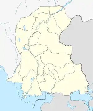
Nawabshah
Nawabshah (Sindhi and Urdu: نوابشاہ) is a city and headquarters of the Shaheed Benazirabad District of Sindh province, Pakistan. It is the 27th largest city in Pakistan.[2]
Nawabshah
نوابشاهه نوابشاہ | |
|---|---|
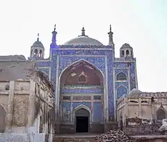 The tomb of Mian Noor Muhammad Kalhoro | |
 Nawabshah  Nawabshah | |
| Coordinates: 26°14′39″N 68°24′36″E | |
| Country | |
| Province | |
| Division | Shaheed Benazir Abad |
| District | Shaheed Benazirabad |
| Area | |
| • Metro | 4,239 km2 (1,637 sq mi) |
| Population | |
| • City | 279,688 |
| • Rank | 27th, Pakistan |
| Time zone | UTC+5 (PST) |
| Number of Taluka | 4 |
| Number of Union councils | 51 |
Etymology
Nawabshah derives its name from Syed Nawab Shah, from the Syed Family of the area, who in 1912 donated 200 acres of land for a railway station to the British Empire. In his honour, the British named it Nawabshah.
Location
It is roughly the geographical center of Sindh province of Pakistan. By road it is 4 hours' drive from the country's largest city and commercial capital Karachi on the National Highway N-5, roughly 50 kilometres from left bank of River Indus. The central geographical location of the city makes it a major train and road transportation hub in the province. It was established by the British Government in 1913.
Agriculture
The city of Nawabshah is set in a lush agricultural region. The city is famous for its sugarcane, mango, national hub of cotton production and one of the largest producer of banana in Pakistan. Nawabshah and its surrounding area produce a significant portion of the total banana production of Pakistan.
Climate
| Nawabshah | ||||||||||||||||||||||||||||||||||||||||||||||||||||||||||||
|---|---|---|---|---|---|---|---|---|---|---|---|---|---|---|---|---|---|---|---|---|---|---|---|---|---|---|---|---|---|---|---|---|---|---|---|---|---|---|---|---|---|---|---|---|---|---|---|---|---|---|---|---|---|---|---|---|---|---|---|---|
| Climate chart (explanation) | ||||||||||||||||||||||||||||||||||||||||||||||||||||||||||||
| ||||||||||||||||||||||||||||||||||||||||||||||||||||||||||||
| ||||||||||||||||||||||||||||||||||||||||||||||||||||||||||||
Nawabshah has a hot desert climate (Köppen climate classification BWh). The city is considered one of the hottest cities in Pakistan, with summer temperatures soaring as high as 53 °C. Temperatures above 45 °C are fairly common during late May and early June. Winters start late, around mid-November, lasting to around mid-February, with night-time temperatures often reaching 4 °C, and temperatures below 0 occurring two or three times on average in January.
The highest temperatures each year in Pakistan, typically rising to above 50 °C (122 °F), are usually recorded in Nawabshah District and Sibi from May to August. The climate is generally dry and hot, but sometimes the temperature falls to 0 °C (32 °F). On 26 May 2010 record breaking severe heat wave hit the city and the mercury level reached 52 °C (126 °F) which was the highest temperature ever recorded in Nawabshah at the time.[6] The climate is generally dry and hot, but sometimes the temperature falls to 0 °C (32 °F). On January 7, 2011 temperatures dropped to 4 °C (39 °F) in the city.[7]
| Climate data for Nawabshah, Pakistan | |||||||||||||
|---|---|---|---|---|---|---|---|---|---|---|---|---|---|
| Month | Jan | Feb | Mar | Apr | May | Jun | Jul | Aug | Sep | Oct | Nov | Dec | Year |
| Record high °C (°F) | 33.7 (92.7) |
38.0 (100.4) |
44.5 (112.1) |
48.5 (119.3) |
51 (124) |
50.5 (122.9) |
47.5 (117.5) |
48.9 (120.0) |
44.5 (112.1) |
43 (109) |
41 (106) |
35 (95) |
51.0 (123.8) |
| Average high °C (°F) | 24.3 (75.7) |
27.5 (81.5) |
33.6 (92.5) |
39.6 (103.3) |
43.4 (110.1) |
43.6 (110.5) |
40.3 (104.5) |
38.8 (101.8) |
38.7 (101.7) |
37.4 (99.3) |
31.9 (89.4) |
25.8 (78.4) |
35.4 (95.7) |
| Average low °C (°F) | 6.1 (43.0) |
8.8 (47.8) |
14.3 (57.7) |
19.7 (67.5) |
24.6 (76.3) |
27.5 (81.5) |
27.4 (81.3) |
26.1 (79.0) |
23.3 (73.9) |
18.4 (65.1) |
12.3 (54.1) |
7.8 (46.0) |
18.0 (64.4) |
| Record low °C (°F) | −2.6 (27.3) |
−3.6 (25.5) |
3 (37) |
7 (45) |
15 (59) |
17 (63) |
20 (68) |
18.9 (66.0) |
14.6 (58.3) |
7.5 (45.5) |
2.8 (37.0) |
−1.0 (30.2) |
−3.6 (25.5) |
| Average precipitation mm (inches) | 1.9 (0.07) |
2.7 (0.11) |
3.4 (0.13) |
2.7 (0.11) |
1.3 (0.05) |
6.6 (0.26) |
54.5 (2.15) |
43.7 (1.72) |
12.9 (0.51) |
3.4 (0.13) |
1.0 (0.04) |
3.6 (0.14) |
114.1 (4.49) |
| Source: [8] | |||||||||||||
Transportation
By railroad
Nawabshah railway station is a railway junction for:
- Main Railway line, Lahore to Karachi.
- Metre Gauge Line, Nawabshah to Jam Saheb & Mirpurkhas.
- Feeder Lines, Padidan, Mahrabpur via Tharushah to Sakrand Nawabshah and Sakrand to Tando Adam via Hala (entire line abandoned/disused).
By highways
- N-5 National Highway passing through Sakrand and Daulatpur Talukas.
- Nawabshah Sakrand Road.
- Nawabshah Kazi Ahmed Road.
- Nawabshah—Sanghar Road.
- Nawabshah Kumb (Mehran Highway) via Bandhi and Daur.
- Nawabshah 60th Mile and Military Chaks.
- Nawabshah Jam Sahib.
- Desert area road, Jam Sahib – Preetamabad District Sanghar.
- Moro Bandhi Road.
- Other link roads connecting Taluka / District Headquarters and others town.
- Nawabshah Khadar road via Mian Shora
By air
Nawabshah Airport is centered on the old (RAF) Royal Air Force World War II base, which is currently being used for commercial flights by Pakistan International Airlines (PIA), Air Blue, Shaheen Air and other local airline services. It is also an alternative to Karachi International Airport.
Nowadays all commercial flights are suspended.
Archeology
The mausoleum of Thul Mir Rukun is an archaeological and historical tomb situated 15 kilometers away from the town of Daulatpur. A road from the town of Kazi Ahmed via Pabjo village leads to Thul Rukan, where one is able to reach this thousand-year-old archaeological construction. The height of this tomb is 60 feet from ground level. Henry Cousin, a British Archaeologist, wrote in his book "Sindhi's Archeology" (Sindhi Translation "Sindh Ja Qadeem Aasaar" by Ata Muhammad Bhambro) that the bricks used in the construction of this tomb were made and prepared in the Buddhist Rulers' period. The line painting for the birth of Gaotam Budh was clearly shown on the bricks, now preserved by the Sindh Archeological Department. He wrote that the ornaments, small effigies and statues were also found when the ground was dug around the tomb.
Chaheen Jo Daro is another archaeological site. It is near the village of Jamalkeerio 2 kilometers from Rohri Canal and 10 kilometers south side from Nawabshah.
Events
The H.M KHOJA Annual Flower Show was introduced by H.M Khoja in 1954 at Khoja Garden. The event is celebrated for 3 to 4 days. It was first organized under the chairmanship of Madam Faryal Talpur in the first tenure of district Nazim Nawabshah and was organized by Khalid Hussain Channa District: Naib Nazim e Ala'a, and D.C.O. Nawabshah Abdul Razaque Qureshi. It was also organised under the social, educational writer and worker Mr. Muhammad Saleh Billoo when he restarted the Annual Flower Show from February 1988.
Notable people
- Asif Ali Zardari, ex-president and first president from Zardari Tribe
- Zahid Ali, Interior designer, Entrepreneur
- Hakim Ali Zardari, known as Rais Hakim Ali Khan, head of the Zardari tribe and served as a federal minister twice
- Shoaib Ahmed Soomro, Entrepreneur, Tech Expert
- Khan Muhammad Dahri
Education
There are various educational institutions in the city, these include:
- Quaid-e-Awam University of Engineering, Science and Technology
- Shaheed Benazir Bhutto University of Veterinary and Animal Sciences[9]
- Shaheed Benazir Bhutto University Shaheed Benazirabad[10]
- Peoples University of Medical and Health Sciences for Women[11]
- Bakhtawar Cadet College For Girls
- The City School, Senior Branch, Society
- Mariam Convent High School
- Foundation Public School (FPS Nwbh)
- AIR Foundation School System
- Fauji Foundation Model School, Society
- Govt. Habib College of Technology,
- Sujawal Academy Nawabshah (S.A.N)
- Karam Ali Jamali Welfare Trust(KAJWT), Nawabshah
- Govt. Degree (Boys) College, Nawabshah
- Govt. Degree (Girls) College, Nawabshah
- Govt. Islamia Girls higher secondary school Nawabshah
- Govt. Sachal Sarmast College, Nawabshah
- Govt. Shaheen Vocational Institute Nawabshah
- SZABIST College, Nawabshah
- Quaid-e-Azam Rangers Public School & College, Nawabshah
- Imperial Science College Sakrand Road Nawabshah
- Deaf Reach School and Training Centre, Nawabshah
- Nawabshah Homoeopathic Medical College & Hospital, Nawabshah
- Govt. Boys High School Bandhi
- TES Public Higher Secondary School, Daur
- Provincial Institute of Teachers Education
- [Bilawal Institute of Historical and Research]
- Excellence College of Information Technology (ECIS)
- National Reforms & Development Organization
- Sindhica Reforms Society ( SRS)
- Gulshan public high school housing society nawabshah
- Noor Model Public School, Marium Road, Nawabshah
- Nawabshah Students Support Organizations NSSO
- Shah Sachal Sami Foundation [12]
- Hari Welfare Association ( HWA)
- Govt: Higher Secondary School Daur
See also
References
- "PAKISTAN: Provinces and Major Cities". PAKISTAN: Provinces and Major Cities. citypopulation.de. Retrieved 4 May 2020.
- "PAKISTAN: Provinces and Major Cities". PAKISTAN: Provinces and Major Cities. citypopulation.de. Retrieved 4 May 2020.
- "Population Welfare Department". Sindh.gov.pk. Archived from the original on 2012-04-07. Retrieved 2011-12-05.
- http://dhsprogram.com/pubs/pdf/FR290/FR290.pdf
- "Climatological Information for Nawabshah, Pakistan". Hong Kong Observatory. Retrieved 30 July 2010.
- "Mercury dips to 4°C in Nawabshah". Dawn.Com. 2010-10-13. Archived from the original on January 25, 2011. Retrieved 2011-01-07.
- "Archived copy". Archived from the original on 2010-06-13. Retrieved 2019-10-05.CS1 maint: archived copy as title (link)
- "..:: SBBUVAS ::." sbbuvas.edu.pk.
- "SBBU (Shaheed Benazir Bhutto University) SBA". sbbusba.edu.pk.
- "!!! PEOPLES UNIVERSITY OF MEDICAL & HEALTH SCIENCES FOR WOMEN- SHAHEED BENAZIRABAD !!!". pumhs.edu.pk.
- "Website Move to New Domain". shahsachalsami.org.
External links
 Nawabshah travel guide from Wikivoyage
- Pakistan Meteorological Department
Pakistan articles | |||||||||||||||||||
|---|---|---|---|---|---|---|---|---|---|---|---|---|---|---|---|---|---|---|---|
| |||||||||||||||||||
| |||||||||||||||||||
| |||||||||||||||||||
| |||||||||||||||||||
| |||||||||||||||||||
| |||||||||||||||||||